Difference between revisions of "2019-03-10 45 -122"
imported>Michael5000 m (→Location) |
imported>FippeBot m (Location) |
||
| (One intermediate revision by one other user not shown) | |||
| Line 23: | Line 23: | ||
== Participants == | == Participants == | ||
| − | |||
| − | |||
| − | + | [[User:Michael5000|Michael5000]] | |
| − | |||
== Expedition == | == Expedition == | ||
| − | |||
| − | + | I drove up to Lewisville Park, which was an well-maintained wooded multi-use area along an attractive stretch of the Lewisville River. From the southern end of the park, I ran along the river trail and then up toward the highway and on to the hashpoint. Now, a problem when you start running along a river is that it's generally uphill in every direction except one, and there was a lot of climbing to be done in the mile-and-change up to the hashpoint. But then, there I was, at the hashpoint. After the usual photo session, I continued the run west to 112th Avenue and then south, eventually calling it a day and walking after about six miles total. That's not a lot for me, but I'll blame the first day of daylight savings time. | |
| − | + | ||
| + | Worth mentioning: it was a glorious day, the first real day of spring, and it was a great treat to be out in the woods and fields. | ||
== Photos == | == Photos == | ||
| − | |||
| − | |||
| − | |||
<gallery perrow="5"> | <gallery perrow="5"> | ||
| + | File:2019-03-10 45 -122 Sign.jpg|Lewisville Park | ||
| + | File:2019-03-10 45 -122 Highway.jpg|Running up the Highway, with Mt. St. Helens in the distance | ||
| + | File:2019-03-10 45 -122 Lane.jpg|The hashpoint | ||
| + | File:2019-03-10 45 -122 Me.jpg|Me, sweating on the hashpoint | ||
</gallery> | </gallery> | ||
| Line 46: | Line 44: | ||
<!-- Add any achievement ribbons you earned below, or remove this section --> | <!-- Add any achievement ribbons you earned below, or remove this section --> | ||
| − | |||
| − | |||
| − | |||
| − | |||
| − | |||
| − | |||
| − | |||
| − | |||
| − | |||
| − | |||
| − | |||
| − | |||
| − | |||
| − | |||
[[Category:Expeditions]] | [[Category:Expeditions]] | ||
| − | |||
[[Category:Expeditions with photos]] | [[Category:Expeditions with photos]] | ||
| − | |||
| − | |||
| − | |||
| − | |||
| − | |||
| − | |||
| − | |||
[[Category:Coordinates reached]] | [[Category:Coordinates reached]] | ||
| − | + | {{location|US|WA|CR}} | |
| − | |||
| − | |||
| − | |||
| − | |||
| − | |||
| − | |||
| − | |||
| − | |||
| − | |||
| − | |||
| − | |||
| − | |||
| − | |||
| − | |||
| − | |||
| − | |||
| − | |||
Latest revision as of 04:33, 16 August 2019
| Sun 10 Mar 2019 in 45,-122: 45.8411256, -122.5374030 geohashing.info google osm bing/os kml crox |
Location
On NE 132nd Avenue, in rural Clark County.
Participants
Expedition
I drove up to Lewisville Park, which was an well-maintained wooded multi-use area along an attractive stretch of the Lewisville River. From the southern end of the park, I ran along the river trail and then up toward the highway and on to the hashpoint. Now, a problem when you start running along a river is that it's generally uphill in every direction except one, and there was a lot of climbing to be done in the mile-and-change up to the hashpoint. But then, there I was, at the hashpoint. After the usual photo session, I continued the run west to 112th Avenue and then south, eventually calling it a day and walking after about six miles total. That's not a lot for me, but I'll blame the first day of daylight savings time.
Worth mentioning: it was a glorious day, the first real day of spring, and it was a great treat to be out in the woods and fields.
Photos
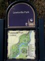
Lewisville Park
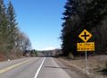
Running up the Highway, with Mt. St. Helens in the distance
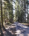
The hashpoint

Me, sweating on the hashpoint


