Difference between revisions of "2019-03-22 45 4"
(→Photos) |
m (per Renaming Proposal) |
||
| (3 intermediate revisions by one other user not shown) | |||
| Line 5: | Line 5: | ||
}} | }} | ||
== Location == | == Location == | ||
| − | In Saint-Didier-au-Mont-d'Or. | + | In [[wikipedia:Saint-Didier-au-Mont-d'Or|Saint-Didier-au-Mont-d'Or]]. |
== Participants == | == Participants == | ||
| − | [[User:Baarde|Baarde]] | + | * [[User:Baarde|Baarde]] |
== Plans == | == Plans == | ||
| Line 31: | Line 31: | ||
== Achievements == | == Achievements == | ||
| − | {{#vardefine:ribbonwidth| | + | {{#vardefine:ribbonwidth|100%}} |
{{land geohash | {{land geohash | ||
| latitude = 45 | | latitude = 45 | ||
| Line 43: | Line 43: | ||
| date = 2019-03-22 | | date = 2019-03-22 | ||
| name = [[User:Baarde|Baarde]] | | name = [[User:Baarde|Baarde]] | ||
| − | | distance = | + | | distance = 23 km |
| bothways = true | | bothways = true | ||
}} | }} | ||
| Line 54: | Line 54: | ||
| reached = true | | reached = true | ||
}} | }} | ||
| − | {{ | + | {{Graticule unlocked |
| latitude = 45 | | latitude = 45 | ||
| longitude = 4 | | longitude = 4 | ||
Latest revision as of 04:51, 20 March 2024
| Fri 22 Mar 2019 in 45,4: 45.8203586, 4.8023541 geohashing.info google osm bing/os kml crox |
Location
Participants
Plans
When at work, I noticed the daily coordinates were only about 11 km from my location. I decided I would bike there on my way back home.
Expedition
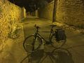
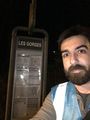
I left work at 19:40, followed the Rhone river northwards, took the Tunnel de la Croix-Rousse, followed the Saône river until Saint-Rambert, where I noticed the path I wanted to take was closed to bicycles. I headed back, climbed a steep street named rue Louis Bouquet, continued through Saint-Cyr-au-Mont-d'Or and Saint-Didier-au-Mont-d'Or and reached the coordinates at Les Gorges bus stop at 20:35 having climbed about 200 m.
It was easier and faster on the way down.
Then I forgot to document the expedition for almost a year and a half.
Photos
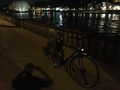
The Saône, my bicycle and me (shadow)
Self congratulation after a hard climb
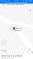
Coordinates reached
Stupid grin
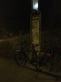
My bike at the coordinates
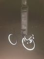
Shiny and chrome


Achievements
Baarde earned the Land geohash achievement
|
Baarde earned the Bicycle geohash achievement
|

Baarde earned the Graticule Unlocked Achievement
|