Difference between revisions of "2019-03-23 43 -80"
imported>Ipswichb m |
imported>Ipswichb m |
||
| Line 39: | Line 39: | ||
Image:3-23-2019 Proof.png | Proof of coordinates reached - and of arrival time. | Image:3-23-2019 Proof.png | Proof of coordinates reached - and of arrival time. | ||
</gallery> | </gallery> | ||
| + | |||
| + | == Achievements == | ||
| + | |||
| + | {{xkcd-100 | latitude = 43 | longitude = -80 | date = 2019-03-23 | distance = 561 miles | name = Ipswichb | image = 3-23-2019 Hashpoint View.jpg }} | ||
| + | |||
[[Category:Expeditions]] | [[Category:Expeditions]] | ||
[[Category:Expeditions with photos]] | [[Category:Expeditions with photos]] | ||
[[Category:Coordinates reached]] | [[Category:Coordinates reached]] | ||
Revision as of 13:16, 24 March 2019
| Sat 23 Mar 2019 in 43,-80: 43.2213311, -80.1555120 geohashing.info google osm bing/os kml crox |
Location
In the middle of a farmer's field near the town of Lynden.
Participants
Plans
The original plans was to park in the Lynden Animal Clinic parking lot nearby, cross the road and what looked like a small field, and from there walk along the edge of the farmer's field until I would walk to the hashpoint.
Expedition
Upon reaching the animal clinic parking lot, I realized it was really more of a house that also had an animal clinic nearby. This looked a little sketchy to me, so instead I decided to just drive to the nearby town of Lynden and park on the street there. This was a great solution, but it meant I had to walk about a mile and a half to the hashpoint. Fortunately, it was decent weather for the first time in ages, so I didn't mind.
I set off south down Lynden Road, and entered the nearby trees after getting out of the little town. I scrambled up the forested hill and found myself at the edge of a very muddy farmer's field. I essentially walked along the edge of the field for a while (it also had a pretty good view of the nearby river) until I was about 100 meters away from the hashpoint, approaching from the South. From there, it was a quick - and muddy - walk north over the field to the hashpoint.
From that point, I simply retraced my steps back along the edge of the field, to Lynden Rd, and back to my car. It was only while walking back that I realized I had reached the coordinates at exactly 3:57pm on a Saturday, making this my first official Saturday meetup! Not surprisingly, no one else seemed to be there. Because I reached these coordinates while on a roadtrip, this means I have achieved the XKCD-100 Achievement.
Photos
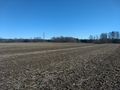
View from hashpoint. I walked along that treeline in order to reach the coordinates.
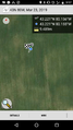
Proof of coordinates reached - and of arrival time.


Achievements
Ipswichb earned the XKCD-100 Achievement
|