Difference between revisions of "2019-03-26 43 1"
imported>Epingchris (→Plans) |
imported>Fippe m (This page has already been categorised, so I removed category:new report.) |
||
| (3 intermediate revisions by 2 users not shown) | |||
| Line 53: | Line 53: | ||
There it is, my first geohash! I had enough time to snap some shots of myself and the surroundings (plus the obligatory screenshot), before I started my way back to the station, this time taking another route to take in more scenery. More cars started appearing on some of the major roads, and at one roundabout near the canal, there was even a slight traffic jam (involving two trucks), unexpected for a "bled" ("village in the middle of nowhere" in French) like this. To be exact, I passed three villages ("communes") today: Dieupentale (where the train station is), Verdun-sur-Garonne (where the geohash point was located), and Bessens (an "Occitan village"), but they were all of minute size, and the houses (mostly farmhouses) were diffusely distributed. | There it is, my first geohash! I had enough time to snap some shots of myself and the surroundings (plus the obligatory screenshot), before I started my way back to the station, this time taking another route to take in more scenery. More cars started appearing on some of the major roads, and at one roundabout near the canal, there was even a slight traffic jam (involving two trucks), unexpected for a "bled" ("village in the middle of nowhere" in French) like this. To be exact, I passed three villages ("communes") today: Dieupentale (where the train station is), Verdun-sur-Garonne (where the geohash point was located), and Bessens (an "Occitan village"), but they were all of minute size, and the houses (mostly farmhouses) were diffusely distributed. | ||
| + | |||
| + | Update: well, a month has passed, and now I think I can safely claim the [[Last man standing achievement]]. | ||
<!-- how it all turned out. your narrative goes here. --> | <!-- how it all turned out. your narrative goes here. --> | ||
| Line 96: | Line 98: | ||
| name = epingchris | | name = epingchris | ||
| image = 20190326431_train.jpg | | image = 20190326431_train.jpg | ||
| + | |||
| + | }} | ||
| + | |||
| + | {{Last man standing | ||
| + | |||
| + | | latitude = 43 | ||
| + | | longitude = 1 | ||
| + | | date = 2019-03-26 | ||
| + | | gender = Man | ||
| + | | name = Epingchris | ||
| + | | image = | ||
}} | }} | ||
| Line 105: | Line 118: | ||
[[Category:Coordinates reached]] | [[Category:Coordinates reached]] | ||
| − | |||
| − | |||
| − | |||
| − | |||
| − | |||
| − | |||
| − | |||
| − | |||
| − | |||
| − | |||
| − | |||
| − | |||
| − | |||
| − | |||
| − | |||
| − | |||
[[Category:Land geohash achievement]] | [[Category:Land geohash achievement]] | ||
[[Category:Public transport geohash achievement]] | [[Category:Public transport geohash achievement]] | ||
| − | + | {{location|FR|82}} | |
| − | |||
| − | |||
| − | |||
| − | |||
| − | {{location}} | ||
| − | |||
[[Category:Coordinates reached]] | [[Category:Coordinates reached]] | ||
| − | |||
| − | |||
| − | |||
| − | |||
| − | |||
| − | |||
| − | |||
| − | |||
| − | |||
| − | |||
| − | |||
| − | |||
| − | |||
| − | |||
| − | |||
| − | |||
| − | |||
| − | |||
Latest revision as of 12:43, 25 July 2019

| Tue 26 Mar 2019 in 43,1: 43.8715833, 1.2347694 geohashing.info google osm bing/os kml crox |
Location
On the roadside in Verdun-sur-Garonne, Tarn-et-Garonne, near Dieupentale, Tarn-et-Garonne.
Participants
Plans
The plan was to take the morning TER train from Toulouse to Dieupentale along with my bike, and then go from there by bike to the hashpoint.
The main challenge is the train schedule: there is exactly one train leaving from Toulouse and arriving at Dieupentale at around 7:50, and another leaving Dieupentale back to Toulouse at around 8:50, meaning that I have to make the round trip on bike in one hour if I don't want to arrive *too* late at work. Supposedly it shouldn't be too difficult, as the estimated distance of the round trip is 4.7 * 2 = 9.4 km, but it means that I won't exactly have the time to wander around leisurely either.
The up side is that both those trains are part of the "Evasio' futé" regional train discount offer: 1 euro per trip! Meaning that besides the time and the extra calories, it would only cost me 2 euros for this trip, which is really affordable even for my currently tight budget.
Expedition
I got up relatively early to prepare for all my bike equipment and things I need for going to work directly after. Luckily my bike remains rideable after several months of inactivity (it was covered, but still left outdoors in the courtyard under a rather rainy and humid winter).
At the station, when I tried to get the 1-euro train ticket, the machine told me to pay 3 euros instead: turns out it only applies if you buy the train ticket on the app (which I did for the return trip). What's more, that price does *not* actually apply to the train that I needed to take for the away...That's about the most eventful thing that has happened during this trip, though.
After I arrived at the Dieupentale station, the second (and last) challenge was to carry my bike --not exactly lightweight-- all across a pedestrian bridge over the tracks (What, you expected an elevator? I was lucky this station had a platform), and then off we go.
Every time I resumed cycling after a long dormancy period in winter (when I really really don't have the courage to get on the wheels), I was reminded over and over again how liberating and jubilant it is to ride a bike, especially in the countryside. The sky was a pure pastel blue on this day, bushes had started to resprout, and the canal was calm and quiet, except for the constant chirping all around. It was a good day for me to kick off my 2019 cycling season despite the chilly morning air.
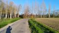
The route given by Google Maps was relatively straightforward (and I noticed that there were only one true left turn, the others were all right turns.) I stopped only twice to take a picture and twice to check my directions, and in 20 minutes I was there, at the end of a smoothly curved portion of a small (and really not well-paved) country road, where it bends towards another direction. An unpaved trail branched off on the left, leading to what seemed like a private domain.
There it is, my first geohash! I had enough time to snap some shots of myself and the surroundings (plus the obligatory screenshot), before I started my way back to the station, this time taking another route to take in more scenery. More cars started appearing on some of the major roads, and at one roundabout near the canal, there was even a slight traffic jam (involving two trucks), unexpected for a "bled" ("village in the middle of nowhere" in French) like this. To be exact, I passed three villages ("communes") today: Dieupentale (where the train station is), Verdun-sur-Garonne (where the geohash point was located), and Bessens (an "Occitan village"), but they were all of minute size, and the houses (mostly farmhouses) were diffusely distributed.
Update: well, a month has passed, and now I think I can safely claim the Last man standing achievement.
Photos
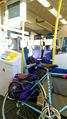
Taking the train
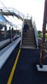
Footdbridge that I had to carry my bike over
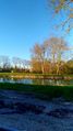
Canal latéral de la Garonne ("Lateral canal of the Garonne river"), part of the Canal des deux mers ("Two seas canal")
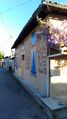
Typical Toulouse-style house
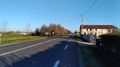
Taking the small road on the left, leaving Dieupentale
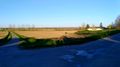
Open field
Coordinate reached!
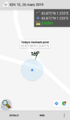
GPS proof
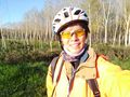
My less-than-goofy smile

Changing the lenses of the sunglasses because the sun was already high up
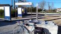
Back at the train station!


Achievements
epingchris earned the Land geohash achievement
|
epingchris earned the Public transport geohash achievement
|
Epingchris earned the Last Man standing achievement
|