Difference between revisions of "2019-03-29 52 -0"
imported>Hedgepig (→Tracklog) |
m (Location correction) |
||
| (18 intermediate revisions by 2 users not shown) | |||
| Line 19: | Line 19: | ||
== Location == | == Location == | ||
| − | A field near | + | A field near Cransley, south east of Kettering Northamptonshire. |
<!-- where you've surveyed the hash to be --> | <!-- where you've surveyed the hash to be --> | ||
== Participants == | == Participants == | ||
[[User:Hedgepig|Hedgepig]] ([[User talk:Hedgepig|talk]]) | [[User:Hedgepig|Hedgepig]] ([[User talk:Hedgepig|talk]]) | ||
| − | + | ||
| − | |||
== Plans == | == Plans == | ||
Vague,my plans always are . | Vague,my plans always are . | ||
| − | + | ||
== Expedition == | == Expedition == | ||
| Line 37: | Line 36: | ||
I went off for the next geocache (unfound for 2 years !) and spent over an hour not finding it, after which I popped back to a spot where I could see most of the field ... agricultural machinery appeared to have gone, so a trot around the field margin to within 40m of the hashpoint, a nervous look around, and I swiftly picked my way along tractor tyre lines to the spot : hoorah ! | I went off for the next geocache (unfound for 2 years !) and spent over an hour not finding it, after which I popped back to a spot where I could see most of the field ... agricultural machinery appeared to have gone, so a trot around the field margin to within 40m of the hashpoint, a nervous look around, and I swiftly picked my way along tractor tyre lines to the spot : hoorah ! | ||
| − | Didn't want to hang around (being 'gerrof my land'-ed at | + | Didn't want to hang around (being 'gerrof my land'-ed at my very first hash would be an ignominious start ) so after a very quick photo of phone with app, GPS with waypoint, and distant view of wind turbines I shot back to the cover of the field margin hedge and regained the right of way without incident. The sense of achievement was only slightly affected by the nasty chemical taste in my mouth, which I hope will not bring my newly minted hashing career and customary rude health to an abrupt halt . |
== Photos == | == Photos == | ||
| − | < | + | |
| − | Image: | + | <gallery perrow="4">Image:2019march29n52w0gps.jpg |GPS he say 1m |
| − | + | Image: 2019march29n52w0phone.jpg |'phone he say at hash | |
| − | + | Image: 2019march29n52wospray.jpg | spray | |
| + | Image : 2019march29n52w0hedgepighashscot.jpg | Hedgepig stunt double/hashscot at nearby geocache | ||
</gallery> | </gallery> | ||
| − | |||
| − | |||
| − | |||
| − | |||
| − | |||
| − | |||
| − | |||
| − | |||
| − | |||
| − | |||
| − | |||
| − | |||
| − | |||
| − | |||
| − | |||
| − | |||
| − | |||
| − | |||
[[Category:Expeditions]] | [[Category:Expeditions]] | ||
| − | |||
[[Category:Expeditions with photos]] | [[Category:Expeditions with photos]] | ||
| − | |||
| − | |||
| − | |||
| − | |||
| − | |||
| − | |||
| − | |||
[[Category:Coordinates reached]] | [[Category:Coordinates reached]] | ||
| − | + | {{location|GB|ENG|NNH}} | |
| − | |||
| − | |||
| − | |||
| − | |||
| − | |||
| − | |||
| − | |||
| − | |||
| − | |||
| − | |||
| − | |||
| − | |||
| − | |||
| − | |||
| − | |||
| − | |||
| − | |||
Latest revision as of 14:09, 4 December 2022
| Fri 29 Mar 2019 in 52,-0: 52.3840244, -0.6600187 geohashing.info google osm bing/os kml crox |
Location
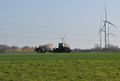
A field near Cransley, south east of Kettering Northamptonshire.
Participants
Plans
Vague,my plans always are .
Expedition
My first ever geohash, after watching and waiting for the internet to land somewhere accessible, not too far from home yet rural. Handily todays point in my next door graticule was off a path which linked two geocaches, so I went along and found the first one, walked on to where I needed to leave the path for approximately a 150m walk to the hash and ... rats ! Crop spraying was underway in the huge arable field I wanted to be in. I couldn't easily plead ignorance of where the actual path went because of some farmer's signs sternly telling me where it wasn't ...
I went off for the next geocache (unfound for 2 years !) and spent over an hour not finding it, after which I popped back to a spot where I could see most of the field ... agricultural machinery appeared to have gone, so a trot around the field margin to within 40m of the hashpoint, a nervous look around, and I swiftly picked my way along tractor tyre lines to the spot : hoorah !
Didn't want to hang around (being 'gerrof my land'-ed at my very first hash would be an ignominious start ) so after a very quick photo of phone with app, GPS with waypoint, and distant view of wind turbines I shot back to the cover of the field margin hedge and regained the right of way without incident. The sense of achievement was only slightly affected by the nasty chemical taste in my mouth, which I hope will not bring my newly minted hashing career and customary rude health to an abrupt halt .
Photos
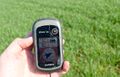
GPS he say 1m

'phone he say at hash
spray
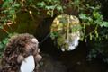
Hedgepig stunt double/hashscot at nearby geocache


