Difference between revisions of "2019-04-25 45 -122"
imported>Michael5000 (Created page with "{{subst:Expedition |lat = 45 |lon = -122 |date = 2019-04-25 }}") |
imported>FippeBot m (Location) |
||
| (One intermediate revision by one other user not shown) | |||
| Line 1: | Line 1: | ||
| − | |||
| − | |||
| − | |||
| − | |||
| − | |||
| − | |||
| − | |||
| − | |||
| − | |||
{{meetup graticule | {{meetup graticule | ||
| lat=45 | | lat=45 | ||
| Line 19: | Line 10: | ||
== Location == | == Location == | ||
| − | + | ||
| + | On Chicago Avenue, a small backstreet in North Portland. | ||
== Participants == | == Participants == | ||
| − | |||
| − | |||
| − | + | *[[User:Michael5000|Michael5000]] | |
| − | |||
== Expedition == | == Expedition == | ||
| − | |||
| − | + | I drove up to North Portland, took the Lombard Street exit, and drove west to Columbia Park. From there, I ran for a while on Princeton Steet, past wholesome spring baseball games and the like, then up the Penninsula Crossing Trail, then west again along Fessenden, and eventually got to the hashpoint, where I took a few pictures. Then I ran east along Fessenden to the Penninsula Crossing Trail, followed it to Princeton Street, and from there headed back west to Columbia Park and my car. 6.55 miles! | |
| − | |||
== Photos == | == Photos == | ||
| − | + | ||
| − | |||
| − | |||
<gallery perrow="5"> | <gallery perrow="5"> | ||
| + | File:2019-04-25 45 -122 me.jpg|View from the hashpoint, looking towards me. | ||
| + | File:2019-04-25 45 -122 street.jpg|View from the hashpoint, looking away from me. | ||
| + | File:2019-04-25 45 -122 bins.jpg|Recycling and yard waste bins at the hashpoint. | ||
| + | File:2019-04-25 45 -122 tree.jpg|Dogwood tree in bloom, not quite at the hashpoint but more attractive than the bins. | ||
</gallery> | </gallery> | ||
== Achievements == | == Achievements == | ||
{{#vardefine:ribbonwidth|800px}} | {{#vardefine:ribbonwidth|800px}} | ||
| − | |||
| − | |||
| − | |||
| − | |||
| − | |||
| − | |||
| − | |||
| − | |||
| − | |||
| − | |||
| − | |||
| − | |||
| − | |||
| − | |||
| − | |||
[[Category:Expeditions]] | [[Category:Expeditions]] | ||
| − | |||
[[Category:Expeditions with photos]] | [[Category:Expeditions with photos]] | ||
| − | |||
| − | |||
| − | |||
| − | |||
| − | |||
| − | |||
| − | |||
[[Category:Coordinates reached]] | [[Category:Coordinates reached]] | ||
| − | + | {{location|US|OR|MU}} | |
| − | |||
| − | |||
| − | |||
| − | |||
| − | |||
| − | |||
| − | |||
| − | |||
| − | |||
| − | |||
| − | |||
| − | |||
| − | |||
| − | |||
| − | |||
| − | |||
| − | |||
Latest revision as of 04:39, 16 August 2019
| Thu 25 Apr 2019 in 45,-122: 45.5959485, -122.7492697 geohashing.info google osm bing/os kml crox |
Location
On Chicago Avenue, a small backstreet in North Portland.
Participants
Expedition
I drove up to North Portland, took the Lombard Street exit, and drove west to Columbia Park. From there, I ran for a while on Princeton Steet, past wholesome spring baseball games and the like, then up the Penninsula Crossing Trail, then west again along Fessenden, and eventually got to the hashpoint, where I took a few pictures. Then I ran east along Fessenden to the Penninsula Crossing Trail, followed it to Princeton Street, and from there headed back west to Columbia Park and my car. 6.55 miles!
Photos

View from the hashpoint, looking towards me.
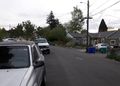
View from the hashpoint, looking away from me.
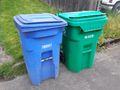
Recycling and yard waste bins at the hashpoint.
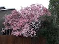
Dogwood tree in bloom, not quite at the hashpoint but more attractive than the bins.


