Difference between revisions of "2019-05-09 39 -77"
imported>OfficeLinebacker (→Participants) |
imported>Fippe (This page has already been categorised, so I removed category:new report. Also: More precise location, image file fix) |
||
| (9 intermediate revisions by 2 users not shown) | |||
| Line 29: | Line 29: | ||
== Plans == | == Plans == | ||
<!-- what were the original plans --> | <!-- what were the original plans --> | ||
| + | I noticed the notification from the [https://geohash.kaiserapps.com/|Geohash notification service] and I realized the place was less than two miles away. Had I been less busy, I would have walked there for another achievement. I planned to get in my car and drive there using Waze. | ||
== Expedition == | == Expedition == | ||
| Line 37: | Line 38: | ||
*Rockville, MD -- [[User:OfficeLinebacker|OfficeLinebacker]] ([[User talk:OfficeLinebacker|talk]]) 19:13, 9 May 2019 (EDT) | *Rockville, MD -- [[User:OfficeLinebacker|OfficeLinebacker]] ([[User talk:OfficeLinebacker|talk]]) 19:13, 9 May 2019 (EDT) | ||
| + | |||
| + | |||
| + | (Notes above from the Geohash Droid app kept for posterity) | ||
| + | |||
| + | I got in my car and at first tried using the "directions" option in the app. Alas, it opened in Google Maps, whereas my preferred navigation app for driving is Waze. Feature request: allow me to choose the navigation app! | ||
| + | |||
| + | I got there and at first pulled into the community center parking lot. I then fired up the Geohash Droid app. I had already driven *through* the hash point before realizing I was already there. | ||
| + | |||
| + | I pulled over and got a selfie, then tried the door on the community center. I think I once took yoga classes there many years ago and I wanted to verify. Alas, the doors were locked. Ignoring the side-eyes from the parents watching their kids tool around on their bikes, I walked to the back of the building and tried the door there. NOTHING SUSPICIOUS GOING ON HERE. | ||
| + | |||
| + | I took a picture of the side of the center, uploaded it, and went upon my merry way. Success! | ||
| + | |||
== Tracklog == | == Tracklog == | ||
<!-- if your GPS device keeps a log, you may post a link here --> | <!-- if your GPS device keeps a log, you may post a link here --> | ||
| Line 45: | Line 58: | ||
--> | --> | ||
<gallery perrow="5"> | <gallery perrow="5"> | ||
| − | + | [[Category: Meetup on 2019-05-09]] | |
| + | [[Category: Meetup in 39 -77]] | ||
Image:2019-05-09_39_-77_OfficeLinebacker_1557444345150.jpg|Made it! [http://www.openstreetmap.org/?lat=39.07551520&lon=-77.14908370&zoom=16&layers=B000FTF @39.0755,-77.1491] | Image:2019-05-09_39_-77_OfficeLinebacker_1557444345150.jpg|Made it! [http://www.openstreetmap.org/?lat=39.07551520&lon=-77.14908370&zoom=16&layers=B000FTF @39.0755,-77.1491] | ||
| Line 54: | Line 68: | ||
{{#vardefine:ribbonwidth|800px}} | {{#vardefine:ribbonwidth|800px}} | ||
<!-- Add any achievement ribbons you earned below, or remove this section --> | <!-- Add any achievement ribbons you earned below, or remove this section --> | ||
| − | |||
| − | |||
| − | |||
| − | |||
<!-- ==REQUEST FOR TWITTER BOT== Please leave either the New report or the Expedition planning category in as long as you work on it. This helps the twitter bot a lot with announcing the right outcome at the right moment. --> | <!-- ==REQUEST FOR TWITTER BOT== Please leave either the New report or the Expedition planning category in as long as you work on it. This helps the twitter bot a lot with announcing the right outcome at the right moment. --> | ||
<!-- Potential categories. Please include all the ones appropriate to your expedition --> | <!-- Potential categories. Please include all the ones appropriate to your expedition --> | ||
| − | |||
| − | |||
| − | |||
| − | + | [[Category:Expeditions]] | |
| − | |||
| − | |||
| − | |||
[[Category:Expeditions with photos]] | [[Category:Expeditions with photos]] | ||
| − | + | ||
| − | + | {{Location|US|MD|MO}} | |
| − | |||
| − | {{ | ||
| − | |||
| − | + | ||
[[Category:Coordinates reached]] | [[Category:Coordinates reached]] | ||
| − | + | {{Speed racer | |
| − | |||
| − | |||
| − | |||
| − | |||
| − | |||
| − | |||
| − | |||
| − | |||
| − | |||
| − | |||
| − | |||
| − | |||
| − | |||
| − | + | | latitude = 39 | |
| + | | longitude = -77 | ||
| + | | date = 2019-05-09 | ||
| + | | name = OfficeLinebacker | ||
| + | | image = 2019-05-09 39 -77 OfficeLinebacker 1557444345150.jpg | ||
| + | | speed = 25 | ||
| + | }} | ||
Latest revision as of 09:54, 25 July 2019
| Thu 9 May 2019 in 39,-77: 39.0754630, -77.1490444 geohashing.info google osm bing/os kml crox |
Location
In the street right in front of the Smith Community Center, in the neighborhood of Mark Commons, MD, USA. This makes it eligible for the Speed Racer Achivement!
Participants
~~me
Plans
I noticed the notification from the notification service and I realized the place was less than two miles away. Had I been less busy, I would have walked there for another achievement. I planned to get in my car and drive there using Waze.
Expedition
- So close to my house I have to try it -- OfficeLinebacker (talk) @39.0930,-77.1553 19:12, 9 May 2019 (EDT)
- Rockville, MD -- OfficeLinebacker (talk) 19:13, 9 May 2019 (EDT)
(Notes above from the Geohash Droid app kept for posterity)
I got in my car and at first tried using the "directions" option in the app. Alas, it opened in Google Maps, whereas my preferred navigation app for driving is Waze. Feature request: allow me to choose the navigation app!
I got there and at first pulled into the community center parking lot. I then fired up the Geohash Droid app. I had already driven *through* the hash point before realizing I was already there.
I pulled over and got a selfie, then tried the door on the community center. I think I once took yoga classes there many years ago and I wanted to verify. Alas, the doors were locked. Ignoring the side-eyes from the parents watching their kids tool around on their bikes, I walked to the back of the building and tried the door there. NOTHING SUSPICIOUS GOING ON HERE.
I took a picture of the side of the center, uploaded it, and went upon my merry way. Success!
Tracklog
Photos
Made it! @39.0755,-77.1491
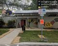
Community Center @39.0757,-77.1492

Achievements

