Difference between revisions of "2019-05-19 -37 144"
imported>Felix Dance ([live picture]At my bike [http://www.openstreetmap.org/?lat=-37.78848610&lon=144.86076600&zoom=16&layers=B000FTF @-37.7885,144.8608]) |
m (More specific location) |
||
| (3 intermediate revisions by 2 users not shown) | |||
| Line 1: | Line 1: | ||
| − | |||
| − | |||
| − | |||
| − | |||
| − | |||
| − | |||
| − | |||
| − | |||
| − | |||
| − | |||
{{meetup graticule | {{meetup graticule | ||
| lat=-37 | | lat=-37 | ||
| Line 14: | Line 4: | ||
| date=2019-05-19 | | date=2019-05-19 | ||
}} | }} | ||
| − | |||
| − | |||
| − | |||
== Location == | == Location == | ||
| − | + | On a suburban driveway in Braybrook. | |
== Participants == | == Participants == | ||
| − | + | *[[User:Felix Dance|Felix Dance]] | |
| − | |||
| − | == | + | == Expedition == |
| − | + | A very easy geohash this one. I'd spotted this in the morning, went out to do various things in the afternoon, then, before dinner I jumped on my road bike, road west for 25 mins and arrived at the hash. | |
| + | |||
| + | When I got there I saw that there was a guy sitting at a table in his open garage just behind the hash, which was in the middle of his driveway. I thought this might stop me from reaching the exact location, but this wasn't to be. | ||
| + | |||
| + | As I arrived, a van pulled up which seemed to be delivering food for some sort of catering business. Using this disruption, I ventured into the driveway and asked the man in the garage if I could stand in the middle of his driveway for a second to take a photo. I expected the usual incomprehension and refusal. | ||
| − | + | To my surprise, the man said 'Yes, no problem', and immediately ignored me. So I stood at the hash point, took a screen shot of my phone for GPS proof, and a couple of photos. Hash success! | |
| − | + | ||
| + | I rode home a different way, taking the Maribyrnong River route home, which was quite awesome during sunset. The whole hash took less than an hour. A tiny consolation for the appalling election results the previous day. | ||
| − | + | [https://goo.gl/maps/cFGCbogNsWG5SKSa6 Here] is the route of my trip. | |
| − | |||
== Photos == | == Photos == | ||
| − | |||
| − | |||
| − | |||
<gallery perrow="5"> | <gallery perrow="5"> | ||
| Line 48: | Line 35: | ||
== Achievements == | == Achievements == | ||
| − | {{ | + | {{bicycle geohash |
| − | |||
| − | + | | latitude = -37 | |
| − | + | | longitude = 144 | |
| − | [[ | + | | date = 2019-05-19 |
| − | + | | name = [[User:Felix Dance|Felix Dance]] | |
| − | + | | distance = 15.6 kms | |
| − | + | | bothways = true | |
| − | + | | image = 2019-05-19_-37_144_Felix Dance_1558250303071.jpg | |
| − | + | }} | |
| − | |||
| − | |||
| − | |||
| − | |||
| − | |||
[[Category:Expeditions]] | [[Category:Expeditions]] | ||
| − | |||
[[Category:Expeditions with photos]] | [[Category:Expeditions with photos]] | ||
| − | |||
| − | |||
| − | |||
| − | |||
| − | |||
| − | |||
| − | |||
[[Category:Coordinates reached]] | [[Category:Coordinates reached]] | ||
| − | + | {{location|AU|VIC|MB}} | |
| − | |||
| − | |||
| − | |||
| − | |||
| − | |||
| − | |||
| − | |||
| − | |||
| − | |||
| − | |||
| − | |||
| − | |||
| − | |||
| − | |||
| − | |||
| − | |||
Latest revision as of 12:56, 1 August 2020
| Sun 19 May 2019 in -37,144: -37.7884647, 144.8607673 geohashing.info google osm bing/os kml crox |
Location
On a suburban driveway in Braybrook.
Participants
Expedition
A very easy geohash this one. I'd spotted this in the morning, went out to do various things in the afternoon, then, before dinner I jumped on my road bike, road west for 25 mins and arrived at the hash.
When I got there I saw that there was a guy sitting at a table in his open garage just behind the hash, which was in the middle of his driveway. I thought this might stop me from reaching the exact location, but this wasn't to be.
As I arrived, a van pulled up which seemed to be delivering food for some sort of catering business. Using this disruption, I ventured into the driveway and asked the man in the garage if I could stand in the middle of his driveway for a second to take a photo. I expected the usual incomprehension and refusal.
To my surprise, the man said 'Yes, no problem', and immediately ignored me. So I stood at the hash point, took a screen shot of my phone for GPS proof, and a couple of photos. Hash success!
I rode home a different way, taking the Maribyrnong River route home, which was quite awesome during sunset. The whole hash took less than an hour. A tiny consolation for the appalling election results the previous day.
Here is the route of my trip.
Photos
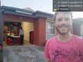
At the hash :) @-37.7885,144.8608
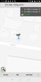
GPS proof

At my bike @-37.7885,144.8608


Achievements
Felix Dance earned the Bicycle geohash achievement
|