Difference between revisions of "2019-05-21 52 0"
From Geohashing
imported>Sourcerer m (Arrived. [http://www.openstreetmap.org/?lat=52.88445532&lon=.69181144&zoom=16&layers=B000FTF @52.8845,.6918]) |
imported>Sourcerer m (Wind Farm [http://www.openstreetmap.org/?lat=52.88445532&lon=.69181144&zoom=16&layers=B000FTF @52.8845,.6918]) |
||
| Line 28: | Line 28: | ||
Image:2019-05-21_52_0_Sourcerer_1558450522000.jpg | Arrived. [http://www.openstreetmap.org/?lat=52.88445532&lon=.69181144&zoom=16&layers=B000FTF @52.8845,.6918] | Image:2019-05-21_52_0_Sourcerer_1558450522000.jpg | Arrived. [http://www.openstreetmap.org/?lat=52.88445532&lon=.69181144&zoom=16&layers=B000FTF @52.8845,.6918] | ||
| + | |||
| + | Image:2019-05-21_52_0_Sourcerer_1558450380000.jpg | Wind Farm [http://www.openstreetmap.org/?lat=52.88445532&lon=.69181144&zoom=16&layers=B000FTF @52.8845,.6918] | ||
</gallery> | </gallery> | ||
Revision as of 15:18, 21 May 2019
| Tue 1 Jan 2019 in Cambridge: 52.9255055, 0.5545349 geohashing.info google osm bing/os kml crox |
Location
A wind farm near Stanhoe, Norfolk, UK.
Planning
It's Geohashing Day. Aim for a 4pm arrival. It's close to a right of way. Crops might prevent access.
Participants
Expedition
- Arrived. -- Sourcerer (talk) @52.8845,.6918 16:15, 21 May 2019 (GMT+01:00)
Photos
- Gallery
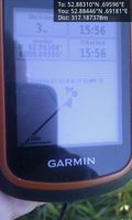
Arrived. @52.8845,.6918
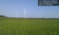
Wind Farm @52.8845,.6918


Achievements
Expeditions and Plans
| 2019-05-21 | ||
|---|---|---|
| Fulda, Germany | GeorgDerReisende | The hash lay on the western side of the Großer Wehneberg at Bad Hersfeld. |
| Cambridge, United Kingdom | Sourcerer | A barley field near a wind farm near Stanhoe, Norfolk, UK. |
| Hannover, Germany | Fippe | located on a field of rye in Bad Fallingbostel. |
| Nilsiä, Finland | Pastori, The Wife | Sotkamo, Sammakkolampi, the point lies in a marsh. |
Sourcerer's Expedition Links
2019-02-13_51_0 - 2019-05-21_52_0 - 2019-02-25_52_1 - KML file download of Sourcerer's expeditions for use with Google Earth.