Difference between revisions of "2019-05-25 45 -122"
imported>Michael5000 (Created page with "{{subst:Expedition |lat = 45 |lon = -122 |date = 2019-05-25 }}") |
imported>FippeBot m (Location) |
||
| (One intermediate revision by one other user not shown) | |||
| Line 19: | Line 19: | ||
== Location == | == Location == | ||
| − | + | ||
| + | Just off the "Old Main Trail" in Tryon Creek State Park. | ||
== Participants == | == Participants == | ||
| − | |||
| − | |||
| − | + | *[[User:Michael5000|Michael5000]] | |
| − | |||
== Expedition == | == Expedition == | ||
| − | |||
| − | + | Expedition #213: It was an unseasonably dark and rainy day, so dark that I actually had the silly thought at one point that maybe there was an eclipse happening that I hadn't heard about. Running didn't sound like much fun, but it turns out that trails under a thick forest canopy is actually a pretty good place to run in the rain; you still get wet, but there's not much wind and everything smells good. I haven't spent much time in Tryon Creek Park, so it was fun to explore the trail network, and to wade off into the wet underbrush at one point so as to stand at the hashpoint. | |
| − | |||
== Photos == | == Photos == | ||
| Line 39: | Line 35: | ||
--> | --> | ||
<gallery perrow="5"> | <gallery perrow="5"> | ||
| + | File:2019-05-25 45 -122 Path.jpg|The Old Main Trail passes a few feet from the hashpoint. | ||
| + | File:2019-05-25 45 -122 Hashpoint.jpg|Here's what it looked like. | ||
| + | File:2019-05-25 45 -122 View.jpg|And such was the view. | ||
</gallery> | </gallery> | ||
== Achievements == | == Achievements == | ||
{{#vardefine:ribbonwidth|800px}} | {{#vardefine:ribbonwidth|800px}} | ||
| − | |||
| − | |||
| − | |||
| − | |||
| − | |||
| − | |||
| − | |||
| − | |||
| − | |||
| − | |||
| − | |||
| − | |||
| − | |||
| − | |||
| − | |||
| − | |||
[[Category:Expeditions]] | [[Category:Expeditions]] | ||
| − | |||
[[Category:Expeditions with photos]] | [[Category:Expeditions with photos]] | ||
| − | |||
| − | |||
| − | |||
| − | |||
| − | |||
| − | |||
| − | |||
[[Category:Coordinates reached]] | [[Category:Coordinates reached]] | ||
| − | + | {{location|US|OR|MU}} | |
| − | |||
| − | |||
| − | |||
| − | |||
| − | |||
| − | |||
| − | |||
| − | |||
| − | |||
| − | |||
| − | |||
| − | |||
| − | |||
| − | |||
| − | |||
| − | |||
| − | |||
Latest revision as of 12:38, 14 July 2019
| Sat 25 May 2019 in 45,-122: 45.4396596, -122.6754436 geohashing.info google osm bing/os kml crox |
Location
Just off the "Old Main Trail" in Tryon Creek State Park.
Participants
Expedition
Expedition #213: It was an unseasonably dark and rainy day, so dark that I actually had the silly thought at one point that maybe there was an eclipse happening that I hadn't heard about. Running didn't sound like much fun, but it turns out that trails under a thick forest canopy is actually a pretty good place to run in the rain; you still get wet, but there's not much wind and everything smells good. I haven't spent much time in Tryon Creek Park, so it was fun to explore the trail network, and to wade off into the wet underbrush at one point so as to stand at the hashpoint.
Photos
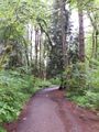
The Old Main Trail passes a few feet from the hashpoint.
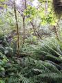
Here's what it looked like.
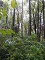
And such was the view.


