Difference between revisions of "2019-05-25 52 0"
imported>Sourcerer m (→Fixed a link) |
imported>Fippe m (Location) |
||
| (4 intermediate revisions by 2 users not shown) | |||
| Line 13: | Line 13: | ||
== Planning == | == Planning == | ||
| − | It's Mouseover Day. Aim for a 4pm arrival. Perhaps it'll be a doublehash with 52, 1. I'll be listening on 145.50 MHz. | + | It's Mouseover Day. Aim for a 4pm arrival. Perhaps it'll be a doublehash with 52, 1 at 2pm. I'll be listening on 145.50 MHz. |
== Participants == | == Participants == | ||
| Line 21: | Line 21: | ||
== Expedition == | == Expedition == | ||
| + | There was no 3G signal so I could not make "live" arrival announcements. The expedition was really nice. Thetford Forest is a beautiful area. The hashpoint was exactly on a footpath a few metres away from a woodland cycle track. I had 30 minutes to kill so I wandered around beech and other trees for about 2.5km, returning to the hashpoint at 4pm. Sadly no other geohashers showed up. The total walk was a bit over 5km. No one was around on 145.5 MHz but lots a cyclists passed nearby including family groups - nice to see. | ||
== Photos == | == Photos == | ||
<gallery caption="Gallery" widths="200px" heights="200px" perrow="3"> | <gallery caption="Gallery" widths="200px" heights="200px" perrow="3"> | ||
| + | Image:2019-05-25_52_0_Sourcerer_1.jpg | Thetford Forest | ||
| + | Image:2019-05-25_52_0_Sourcerer_2.jpg | Half and hour to kill | ||
| + | Image:2019-05-25_52_0_Sourcerer_3.jpg | Thetford Forest | ||
| + | Image:2019-05-25_52_0_Sourcerer_4.jpg | Thetford Forest | ||
| + | Image:2019-05-25_52_0_Sourcerer_5.jpg | Thetford Forest | ||
| + | Image:2019-05-25_52_0_Sourcerer_6.jpg | Thetford Forest | ||
| + | Image:2019-05-25_52_0_Sourcerer_7.jpg | 4pm back at the hashpoint | ||
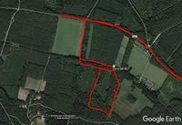
| + | Image:2019-05-25_52_0_Sourcerer_8.jpg | Google Earth Double Hash | ||
| + | Image:2019-05-25_52_0_Sourcerer_9.jpg | Half Hour Walk in the Area | ||
</gallery> | </gallery> | ||
| Line 29: | Line 39: | ||
{{Sourcerer_links | {{Sourcerer_links | ||
| − | | prev = 2019- | + | | prev = 2019-05-25_52_1 |
| curr = 2019-05-25_52_0 | | curr = 2019-05-25_52_0 | ||
| next = 2019-05-26_52_1 | | next = 2019-05-26_52_1 | ||
| Line 35: | Line 45: | ||
}} | }} | ||
| − | [[Category: | + | [[Category:Expeditions]] |
[[Category:Expeditions with photos]] | [[Category:Expeditions with photos]] | ||
| − | [[Category:Coordinates | + | [[Category:Coordinates reached]] |
| + | {{location|GB|ENG|SFK}} | ||
Latest revision as of 22:43, 14 July 2019
| Sat 25 May 2019 in Cambridge: 52.4396596, 0.6754436 geohashing.info google osm bing/os kml crox |
Location
East of Brandon and south of the B1107, close to a forest track, Suffolk, UK.
Planning
It's Mouseover Day. Aim for a 4pm arrival. Perhaps it'll be a doublehash with 52, 1 at 2pm. I'll be listening on 145.50 MHz.
Participants
Expedition
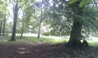
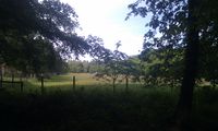
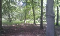
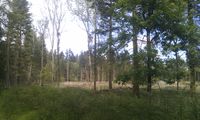
There was no 3G signal so I could not make "live" arrival announcements. The expedition was really nice. Thetford Forest is a beautiful area. The hashpoint was exactly on a footpath a few metres away from a woodland cycle track. I had 30 minutes to kill so I wandered around beech and other trees for about 2.5km, returning to the hashpoint at 4pm. Sadly no other geohashers showed up. The total walk was a bit over 5km. No one was around on 145.5 MHz but lots a cyclists passed nearby including family groups - nice to see.
Photos
- Gallery
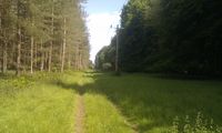
Thetford Forest
Half and hour to kill
Thetford Forest
Thetford Forest
Thetford Forest
Thetford Forest
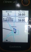
4pm back at the hashpoint
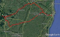
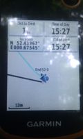
Google Earth Double Hash
Half Hour Walk in the Area


Achievements
Expeditions and Plans
| 2019-05-25 | ||
|---|---|---|
| Portland, Oregon | Michael5000 | Just off the "Old Main Trail" in Tryon Creek State Park. |
| Düsseldorf, Germany | GeorgDerReisende | The hash lay on the Ruhrorter Straße in Duisburg-Hochheide. |
| Cambridge, United Kingdom | Sourcerer | East of Brandon and south of the B1107, close to a forest track, Suffolk, U... |
| Norwich, United Kingdom | Sourcerer | Very close to a right of way, between Mutford and Carlton Colville, Suffolk... |
| Braunschweig, Germany | Fippe | located in a forest near the Ilkerbruch. |
| Amsterdam, Netherlands | FelixTheCat | Spaarnwoude recreational area, Velsen municipality, North Holland province.... |
Sourcerer's Expedition Links
2019-05-25_52_1 - 2019-05-25_52_0 - 2019-05-26_52_1 - KML file download of Sourcerer's expeditions for use with Google Earth.