Difference between revisions of "2019-05-25 52 1"
From Geohashing
imported>Sourcerer m ([live picture] HP Area [http://www.openstreetmap.org/?lat=52.43965924&lon=1.67546332&zoom=16&layers=B000FTF @52.4397,1.6755]) |
imported>Sourcerer m (→Photos) |
||
| Line 24: | Line 24: | ||
== Photos == | == Photos == | ||
<gallery caption="Gallery" widths="200px" heights="200px" perrow="3"> | <gallery caption="Gallery" widths="200px" heights="200px" perrow="3"> | ||
| − | + | Image:2019-05-25_52_1_Sourcerer.jpg | Google Earth Track | |
Image:2019-05-25_52_1_Sourcerer_1558787440202.jpg | Arrived. [http://www.openstreetmap.org/?lat=52.43965924&lon=1.67545795&zoom=16&layers=B000FTF @52.4397,1.6755] | Image:2019-05-25_52_1_Sourcerer_1558787440202.jpg | Arrived. [http://www.openstreetmap.org/?lat=52.43965924&lon=1.67545795&zoom=16&layers=B000FTF @52.4397,1.6755] | ||
Revision as of 16:50, 25 May 2019
| Sat 25 May 2019 in Norwich: 52.4396596, 1.6754436 geohashing.info google osm bing/os kml crox |
Location
Very close to a right of way, between Mutford and Carlton Colville, Suffolk, UK.
Planning
It's Mouseover Day. Aim for a 2pm arrival at 52, 1 and visit 52, 0 at around 4pm. I'll be listening on 145.50 MHz.
Participants
Expedition
Photos
- Gallery
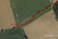
Google Earth Track
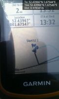
Arrived. @52.4397,1.6755
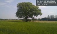
HP Area @52.4397,1.6755


Achievements
Expeditions and Plans
| 2019-05-25 | ||
|---|---|---|
| Portland, Oregon | Michael5000 | Just off the "Old Main Trail" in Tryon Creek State Park. |
| Düsseldorf, Germany | GeorgDerReisende | The hash lay on the Ruhrorter Straße in Duisburg-Hochheide. |
| Cambridge, United Kingdom | Sourcerer | East of Brandon and south of the B1107, close to a forest track, Suffolk, U... |
| Norwich, United Kingdom | Sourcerer | Very close to a right of way, between Mutford and Carlton Colville, Suffolk... |
| Braunschweig, Germany | Fippe | located in a forest near the Ilkerbruch. |
| Amsterdam, Netherlands | FelixTheCat | Spaarnwoude recreational area, Velsen municipality, North Holland province.... |
Sourcerer's Expedition Links
2019-05-21_52_0 - 2019-05-25_52 1 - 2019-05-25_52_0 - KML file download of Sourcerer's expeditions for use with Google Earth.