2019-05-21 52 0
| Tue 21 May 2019 in Cambridge: 52.8830994, 0.6959560 geohashing.info google osm bing/os kml crox |
Location
A barley field near a wind farm near Stanhoe, Norfolk, UK.
Planning
It's Geohashing Day. Aim for a 4pm arrival. It's close to a right of way. Crops might prevent access.
Participants
Expedition
- Arrived. -- Sourcerer (talk) @52.8845,.6918 16:15, 21 May 2019 (GMT+01:00)
Just before 4pm, at the hashpoint, GeohashDroid went on the blink. It was my fault. I'd purged my phone's storage to free up space and had failed to re-enter any credentials needed by the app. It took a while to remember how to fix all that so my photo uploads were made quite near but not at the hashpoint.
It was an enjoyable outing in fine spring weather. The barley field was coming into flower and I had a fierce attack of hay fever about 45 minutes after leaving the field. I mostly stuck to tractor tracks but still stirred up quite a lot of pollen.
There was a very nice wildlife/biodiversity zone with a weedy area full of flowers for bees and other polinators. That zone also provided cover for birds and animals. There was a small copse with trees and undergrowth. More diverse habitat. It would be good if more farmers did this and over larger areas too.
Photos
- Gallery
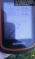
Arrived. @52.8845,.6918
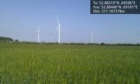
Wind Farm @52.8845,.6918
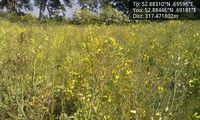
Seed for birds - nice! @52.8845,.6918
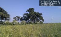
Trees near the hashpoint. @52.8845,.6918
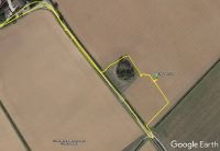
Google Earth Track


Achievements
Expeditions and Plans
| 2019-05-21 | ||
|---|---|---|
| Fulda, Germany | GeorgDerReisende | The hash lay on the western side of the Großer Wehneberg at Bad Hersfeld. |
| Cambridge, United Kingdom | Sourcerer | A barley field near a wind farm near Stanhoe, Norfolk, UK. |
| Hannover, Germany | Fippe | located on a field of rye in Bad Fallingbostel. |
| Nilsiä, Finland | Pastori, The Wife | Sotkamo, Sammakkolampi, the point lies in a marsh. |
Sourcerer's Expedition Links
2019-02-13_51_0 - 2019-05-21_52_0 - 2019-05-25_52_1 - KML file download of Sourcerer's expeditions for use with Google Earth.