Difference between revisions of "2019-05-30 47 11"
From Geohashing
m |
|||
| Line 1: | Line 1: | ||
| − | |||
| − | |||
| − | |||
| − | |||
| − | |||
| − | |||
| − | |||
| − | |||
| − | |||
| − | |||
{{meetup graticule | {{meetup graticule | ||
| lat=47 | | lat=47 | ||
| Line 15: | Line 5: | ||
}} | }} | ||
| − | |||
__NOTOC__ | __NOTOC__ | ||
== Location == | == Location == | ||
| − | + | At or rather in the river Isar between Wallgau and the Sylvenstein Reservoir | |
== Participants == | == Participants == | ||
| − | |||
| − | |||
*[[User:Solli|Solli]] | *[[User:Solli|Solli]] | ||
== Plans == | == Plans == | ||
| − | + | The River is usually quite shallow in this part, so the plan was to drive to the northern bank and try to wade to the hashpoint. | |
== Expedition == | == Expedition == | ||
| − | + | Unfortunately the water level was very high due to meltwater from the mountains. I drove to the bank anyway and gave it a look. I also managed to wade a few steps. But since the river was also quite rapid, going further would have been dangerous to life. I took some photos and got back to the car. Even if the expedition was not successful, it was quite an adventure. | |
| − | == | + | == Photos == |
| − | + | Coming soon... | |
| − | |||
| − | |||
| − | |||
| − | |||
<gallery perrow="5"> | <gallery perrow="5"> | ||
| Line 45: | Line 28: | ||
== Achievements == | == Achievements == | ||
| − | |||
| − | |||
| − | |||
[[Category:Expeditions]] | [[Category:Expeditions]] | ||
{{location|DE|BY|TÖL}} | {{location|DE|BY|TÖL}} | ||
[[Category:Coordinates not reached]] | [[Category:Coordinates not reached]] | ||
[[Category:Not reached - Mother Nature]] | [[Category:Not reached - Mother Nature]] | ||
Revision as of 08:35, 26 April 2022
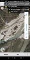
| Thu 30 May 2019 in 47,11: 47.5397179, 11.3520946 geohashing.info google osm bing/os kml crox |
Location
At or rather in the river Isar between Wallgau and the Sylvenstein Reservoir
Participants
Plans
The River is usually quite shallow in this part, so the plan was to drive to the northern bank and try to wade to the hashpoint.
Expedition
Unfortunately the water level was very high due to meltwater from the mountains. I drove to the bank anyway and gave it a look. I also managed to wade a few steps. But since the river was also quite rapid, going further would have been dangerous to life. I took some photos and got back to the car. Even if the expedition was not successful, it was quite an adventure.
Photos
Coming soon...
Not reached, details follow @47.5402,11.3509
