Difference between revisions of "2019-06-04 52 9"
imported>GeorgDerReisende (planning an expedition to Isernhagen) |
m (Adding hours) |
||
| (4 intermediate revisions by 3 users not shown) | |||
| Line 1: | Line 1: | ||
| + | [[Image:{{{image|2019-06-04 52 9 GeorgDerReisende 0001.jpg}}}|thumb|left]] | ||
| − | |||
| − | |||
| − | |||
| − | |||
| − | |||
| − | |||
| − | |||
| − | |||
| − | |||
{{meetup graticule | {{meetup graticule | ||
| lat=52 | | lat=52 | ||
| Line 20: | Line 12: | ||
== Location == | == Location == | ||
| − | at a ditch west of Gartenstadt Lohne | + | This Geohash is located at a ditch west of [[wikipedia:Isernhagen|Gartenstadt Lohne]]. |
== Participants == | == Participants == | ||
| − | + | * [[User:GeorgDerReisende|GeorgDerReisende]] | |
| − | [[User:GeorgDerReisende|GeorgDerReisende]] | + | * [[User:Fippe|Fippe]] |
== Plans == | == Plans == | ||
| − | + | ===GeorgDerReisende=== | |
arriving there at 12 o'clock | arriving there at 12 o'clock | ||
== Expedition == | == Expedition == | ||
| − | + | ===GeorgDerReisende=== | |
| + | |||
| + | I misunderstood the timetables and the arriving time was 12:42. On the way to the hash I found a golf course hiking trail and I took it. To find the hash was easy. As I am without GPS, I looked for the southeastern edge of the tree. | ||
| + | |||
| + | ===Fippe=== | ||
| + | I took the tram to Altwarmbüchen and walked the rest from there. I could not go in a straight line, since the [[wikipedia:Autobahn 7|Autobahn 7]] was between me and the coordinates. | ||
| + | |||
| + | After reaching the bridge, I crossed it and went around a golf course. The public path actually seperated two parts of the golf course from each other, so I was basically walking on the course. This is no [[Golf Geohash]] though, the coordinates are a little further. | ||
| + | |||
| + | When I arrived at the site, I saw flattened grass all the way to the coordinates. Georg was here before me, like he announced. I could only make it at 16:00, four hours after him. I located the coordinates and recorded proof. | ||
| + | |||
| + | Afterwards, I went to Lohne. Waiting for the bus, I saw an airplane, the airport is nearby. I took a bus back to Altwarmbüchen and took the tram back home. | ||
== Tracklog == | == Tracklog == | ||
| Line 37: | Line 40: | ||
== Photos == | == Photos == | ||
| − | < | + | ===GeorgDerReisende=== |
| − | + | <gallery> | |
| − | -- | + | 2019-06-04 52 9 GeorgDerReisende 9607.jpg | arrived at Lohne |
| − | + | 2019-06-04 52 9 GeorgDerReisende 9611.jpg | golf course hiking trail | |
| + | 2019-06-04 52 9 GeorgDerReisende 9612.jpg | the golf course hiking trail leading to the hash | ||
| + | 2019-06-04 52 9 GeorgDerReisende 9618.jpg | the tree of hash | ||
| + | 2019-06-04 52 9 GeorgDerReisende 9620.jpg | the hash | ||
| + | 2019-06-04 52 9 GeorgDerReisende 9622.jpg | the tree, old and dead | ||
| + | 2019-06-04 52 9 GeorgDerReisende 9623.jpg | looking west | ||
| + | 2019-06-04 52 9 GeorgDerReisende 9624.jpg | north | ||
| + | 2019-06-04 52 9 GeorgDerReisende 9625.jpg | east | ||
| + | 2019-06-04 52 9 GeorgDerReisende 9626.jpg | and south | ||
| + | 2019-06-04 52 9 GeorgDerReisende 9627.jpg | and GeorgDerReisende | ||
</gallery> | </gallery> | ||
| − | == | + | ===Fippe=== |
| − | + | <gallery> | |
| − | + | 2019-06-04 52 09 01 Altwarmbüchen.jpg | Leaving Altwarmbüchen | |
| + | 2019-06-04 52 09 02 Path.jpg | On the way | ||
| + | 2019-06-04 52 09 03 Bridge.jpg | Over the highway | ||
| + | 2019-06-04 52 09 04 Path.jpg | On the path next to the golf course | ||
| + | 2019-06-04 52 09 05 Warning.jpg | Beware of flying golf balls | ||
| + | 2019-06-04 52 09 06 Golf.jpg | On the golf course | ||
| + | 2019-06-04 52 09 07 Site.jpg | Georg was here | ||
| + | 2019-06-04 52 09 08 Proof.png | Proof | ||
| + | 2019-06-04 52 09 09 Geohash.jpg | The Geohash | ||
| + | 2019-06-04 52 09 10 Surroundings.jpg | Surroundings | ||
| + | 2019-06-04 52 09 11 Surroundings.jpg | Surroundings | ||
| + | 2019-06-04 52 09 12 Surroundings.jpg | Surroundings | ||
| + | 2019-06-04 52 09 13 Surroundings.jpg | Surroundings | ||
| + | 2019-06-04 52 09 14 Lohne.jpg | In Lohne | ||
| + | 2019-06-04 52 09 15 Airplane.jpg | An Airplane | ||
| + | </gallery> | ||
| − | + | ==Ribbons== | |
| − | + | {{#vardefine:ribbonwidth|100%}} | |
| − | [[ | + | {{land geohash|latitude=52|longitude=9|date=2019-06-04|name=[[User:GeorgDerReisende|GeorgDerReisende]] and [[User:Fippe|Fippe]]|image=2019-06-04 52 09 09 Geohash.jpg}} |
| − | + | __NOTOC__ | |
| − | |||
| − | |||
| − | |||
| − | |||
| − | |||
| − | |||
| − | |||
| − | |||
| − | |||
[[Category:Expeditions]] | [[Category:Expeditions]] | ||
| − | + | [[Category:Coordinates reached]] | |
[[Category:Expeditions with photos]] | [[Category:Expeditions with photos]] | ||
| − | + | {{location|DE|NI|H}} | |
| − | + | {{user categories|user=Fippe|tram=43|foot=6|bus=7|hours=16}} | |
| − | |||
| − | {{ | ||
| − | |||
| − | |||
| − | |||
| − | |||
| − | |||
| − | |||
| − | |||
| − | |||
| − | |||
| − | |||
| − | |||
| − | |||
| − | |||
| − | |||
| − | |||
| − | |||
| − | |||
| − | |||
| − | |||
| − | |||
| − | |||
| − | |||
Latest revision as of 19:17, 11 December 2022

| Tue 4 Jun 2019 in 52,9: 52.4520814, 9.8719524 geohashing.info google osm bing/os kml crox |
Location
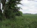
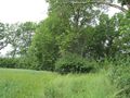
This Geohash is located at a ditch west of Gartenstadt Lohne.
Participants
Plans
GeorgDerReisende
arriving there at 12 o'clock
Expedition
GeorgDerReisende
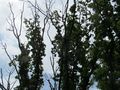
I misunderstood the timetables and the arriving time was 12:42. On the way to the hash I found a golf course hiking trail and I took it. To find the hash was easy. As I am without GPS, I looked for the southeastern edge of the tree.
Fippe
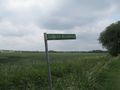
I took the tram to Altwarmbüchen and walked the rest from there. I could not go in a straight line, since the Autobahn 7 was between me and the coordinates.
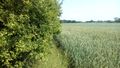
After reaching the bridge, I crossed it and went around a golf course. The public path actually seperated two parts of the golf course from each other, so I was basically walking on the course. This is no Golf Geohash though, the coordinates are a little further.
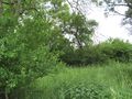
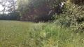
When I arrived at the site, I saw flattened grass all the way to the coordinates. Georg was here before me, like he announced. I could only make it at 16:00, four hours after him. I located the coordinates and recorded proof.
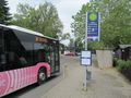
Afterwards, I went to Lohne. Waiting for the bus, I saw an airplane, the airport is nearby. I took a bus back to Altwarmbüchen and took the tram back home.
Tracklog
Photos
GeorgDerReisende
arrived at Lohne
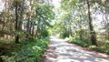
golf course hiking trail
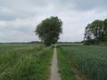
the golf course hiking trail leading to the hash
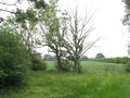
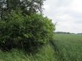
the tree of hash
the hash
the tree, old and dead
looking west
north
east
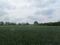
and south
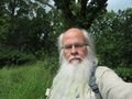
and GeorgDerReisende


Fippe
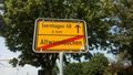
Leaving Altwarmbüchen
On the way
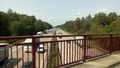
Over the highway
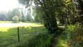
On the path next to the golf course
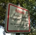
Beware of flying golf balls
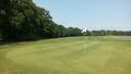
On the golf course
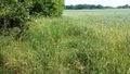
Georg was here
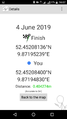
Proof
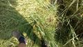
The Geohash
Surroundings
Surroundings
Surroundings
Surroundings
In Lohne
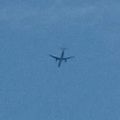
An Airplane


Ribbons
GeorgDerReisende and Fippe earned the Land geohash achievement
|