Difference between revisions of "2019-06-23 43 -79"
imported>Frogman (An expedition message sent via Geohash Droid for Android.) |
m (More specific location) |
||
| (6 intermediate revisions by 2 users not shown) | |||
| Line 1: | Line 1: | ||
| − | |||
| − | |||
| − | |||
| − | |||
| − | |||
| − | |||
| − | |||
| − | |||
| − | |||
| − | |||
{{meetup graticule | {{meetup graticule | ||
| lat=43 | | lat=43 | ||
| Line 15: | Line 5: | ||
}} | }} | ||
| − | |||
__NOTOC__ | __NOTOC__ | ||
== Location == | == Location == | ||
| − | + | On a pathway in a residential community in North York. | |
== Participants == | == Participants == | ||
| − | + | *[[User:Frogman|Frogman]] | |
| − | |||
== Plans == | == Plans == | ||
| − | + | This is the first reasonably-accessible hashpoint in a while, so you can bet I'm spending my Sunday morning going there. | |
== Expedition == | == Expedition == | ||
| − | + | I woke up early (10 am) and took the 135 to Warden Station, Line 2 to Bloor-Yonge, and finally Line 1 to Sheppard-Yonge. The subway was very crowded, with the Pride festivities downtown! From Sheppard-Yonge it was a short walk to the hashpoint, and then a short walk back to travel back home. I took the opportunity to get off at Bloor-Yonge and walk down Church street to enjoy the sunshine and check out the Pride street fair. I took the 506 from Church and Carlton back to Main Street station, and then the 135 back home. | |
| − | |||
| − | |||
| − | |||
== Photos == | == Photos == | ||
| Line 39: | Line 24: | ||
--> | --> | ||
<gallery perrow="5"> | <gallery perrow="5"> | ||
| + | |||
| + | Image:2019-06-23_43_-79_frogman_1561311135284.jpg|North York! | ||
| + | |||
| + | Image:2019-06-23_43_-79_frogman_1561311146939.jpg|Made it! | ||
| + | |||
| + | Image:2019-06-23_43_-79_frogman_1561311164033.jpg|A quiet residential pathway. | ||
| + | |||
| + | Image:2019-06-23_43_-79_frogman_1561311182830.jpg|My grin, a bit goofier than usual. | ||
</gallery> | </gallery> | ||
== Achievements == | == Achievements == | ||
{{#vardefine:ribbonwidth|800px}} | {{#vardefine:ribbonwidth|800px}} | ||
| − | + | {{Public transport geohash | |
| − | + | | latitude = 43 | |
| − | + | | longitude = -79 | |
| − | [[ | + | | date = 2019-06-23 |
| + | | busline = the TTC | ||
| + | | name = [[User:Frogman|Frogman]] | ||
| − | + | }} | |
| − | |||
| − | |||
| − | |||
| − | |||
| − | |||
| − | |||
| − | |||
[[Category:Expeditions]] | [[Category:Expeditions]] | ||
| − | |||
[[Category:Expeditions with photos]] | [[Category:Expeditions with photos]] | ||
| − | |||
| − | |||
| − | |||
| − | |||
| − | |||
| − | |||
| − | |||
[[Category:Coordinates reached]] | [[Category:Coordinates reached]] | ||
| − | + | {{location|CA|ON|TO}} | |
| − | |||
| − | |||
| − | |||
| − | |||
| − | |||
| − | |||
| − | |||
| − | |||
| − | |||
| − | |||
| − | |||
| − | |||
| − | |||
| − | |||
| − | |||
| − | |||
| − | |||
Latest revision as of 00:17, 10 August 2020
| Sun 23 Jun 2019 in 43,-79: 43.7579469, -79.4053024 geohashing.info google osm bing/os kml crox |
Location
On a pathway in a residential community in North York.
Participants
Plans
This is the first reasonably-accessible hashpoint in a while, so you can bet I'm spending my Sunday morning going there.
Expedition
I woke up early (10 am) and took the 135 to Warden Station, Line 2 to Bloor-Yonge, and finally Line 1 to Sheppard-Yonge. The subway was very crowded, with the Pride festivities downtown! From Sheppard-Yonge it was a short walk to the hashpoint, and then a short walk back to travel back home. I took the opportunity to get off at Bloor-Yonge and walk down Church street to enjoy the sunshine and check out the Pride street fair. I took the 506 from Church and Carlton back to Main Street station, and then the 135 back home.
Photos
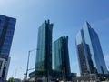
North York!
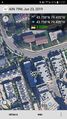
Made it!
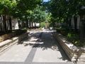
A quiet residential pathway.

My grin, a bit goofier than usual.


Achievements
Frogman earned the Public transport geohash achievement
|