Difference between revisions of "2019-07-04 43 -79"
imported>Frogman ([live picture]Beautiful view of downtown) |
m (More specific location) |
||
| (3 intermediate revisions by 2 users not shown) | |||
| Line 1: | Line 1: | ||
| + | [[Image:{{{image|2019-07-04_43_-79_frogman_1562243619081.jpg}}}|thumb|left]] | ||
| − | |||
| − | |||
| − | |||
| − | |||
| − | |||
| − | |||
| − | |||
| − | |||
| − | |||
{{meetup graticule | {{meetup graticule | ||
| lat=43 | | lat=43 | ||
| Line 15: | Line 7: | ||
}} | }} | ||
| − | |||
__NOTOC__ | __NOTOC__ | ||
== Location == | == Location == | ||
| − | + | Very near the shore in Tommy Thompson Park. | |
== Participants == | == Participants == | ||
| − | + | *[[User:Frogman|Frogman]] | |
| − | |||
== Plans == | == Plans == | ||
| − | + | Thanks to July 4th, when we celebrate when a bunch of rich white men in Boston got angry about taxes, the coordinates were available a day early! This hashpoint looked reachable, so I set my alarm for an early departure and prepared to bike out there. | |
== Expedition == | == Expedition == | ||
| − | + | I left my apartment at about 6:30 am and rode down to Kingston Road. From there I took Fallingbrook down to Queen, and then Silver Birch down to the trail that runs along the lake. I followed that trail out to the intersection of Leslie Street and Lakeshore, which is the location of the Leslie Barns, where all of the fancy new low-floor streetcars (Flexity Outlook model) are kept overnight. | |
| + | |||
| + | Leslie Street runs south into the "Leslie Street Spit", a bit of artificially-created land south of Leslie Street which [https://en.wikipedia.org/wiki/Leslie_Street_Spit Wikipedia] points out isn't actually a spit and could be referred to by the official name "Outer Harbour East Headland", except no one actually calls it that. A good bit of the Leslie Street Spit is covered by Tommy Thompson Park, which is very pretty and has a lot of wildlife, greenery, and a nice multi-use path that was very well-used. I passed a lot of people jogging and biking. The views of downtown were gorgeous! | ||
| + | |||
| + | The hashpoint was past a floating bridge. Unfortunately, the bridge was closed due to the high water levels in Lake Ontario. Indeed, the bridge was deconstructed, so that even if I was feeling like being a scofflaw today I wouldn't have been able to make it. | ||
| − | + | I called the expedition off, even though there was an alternate path, for three reasons. First, I wasn't entirely sure that the other way around was open to the public -- there were signs suggesting that it wasn't, but it was unclear if the signs were referring to the entire eastern portion of the headlands or just one of the several ways to get over there. Second, this alternate road was long and appeared largely unimproved, and so it would have either been unpleasant to bike on, or have taken a very long time to walk on. Third, the aforementioned high water levels meant that the hashpoint, instead of being slightly submerged as was suggested by satellite imagery, would likely have been very underwater and quite a bit more offshore than normal. | |
| − | + | ||
| + | However, I'm glad that I made the attempt! The weather was very nice that early in the day, and the views of downtown were gorgeous. I stood for a few minutes, taking in the sound of birds and the cool morning breeze, and then headed off to the office. | ||
== Photos == | == Photos == | ||
| Line 40: | Line 35: | ||
<gallery perrow="5"> | <gallery perrow="5"> | ||
| − | Image:2019-07-04_43_-79_frogman_1562243550811.jpg|Leslie Barns: "The streetcars sleep | + | Image:2019-07-04_43_-79_frogman_1562243550811.jpg|Leslie Barns: "The streetcars sleep here™" |
Image:2019-07-04_43_-79_frogman_1562243569282.jpg|Tommy Thompson Park! | Image:2019-07-04_43_-79_frogman_1562243569282.jpg|Tommy Thompson Park! | ||
| Line 51: | Line 46: | ||
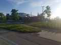
Image:2019-07-04_43_-79_frogman_1562243619081.jpg|Beautiful view of downtown | Image:2019-07-04_43_-79_frogman_1562243619081.jpg|Beautiful view of downtown | ||
| + | |||
| + | Image:2019-07-04_43_-79_frogman_1562243631354.jpg|This is as close as I got! | ||
</gallery> | </gallery> | ||
== Achievements == | == Achievements == | ||
{{#vardefine:ribbonwidth|800px}} | {{#vardefine:ribbonwidth|800px}} | ||
| − | |||
| − | + | {{My kingdom for a boat | |
| − | |||
| − | |||
| − | + | | latitude = 43 | |
| + | | longitude = -79 | ||
| + | | date = 2019-07-04 | ||
| + | | name = [[User:Frogman|Frogman]] | ||
| + | | waterhazard = flooding from Lake Ontario | ||
| + | | image = 2019-07-04_43_-79_frogman_1562243605735.jpg | ||
| − | + | }} | |
| − | |||
| − | |||
| − | |||
| − | |||
| − | |||
[[Category:Expeditions]] | [[Category:Expeditions]] | ||
| − | |||
[[Category:Expeditions with photos]] | [[Category:Expeditions with photos]] | ||
| − | |||
| − | |||
| − | |||
| − | |||
| − | |||
| − | |||
| − | |||
| − | |||
| − | |||
| − | |||
| − | |||
[[Category:Coordinates not reached]] | [[Category:Coordinates not reached]] | ||
| − | |||
| − | |||
[[Category:Not reached - Mother Nature]] | [[Category:Not reached - Mother Nature]] | ||
| − | + | {{location|CA|ON|TO}} | |
| − | |||
| − | |||
| − | |||
| − | |||
| − | |||
| − | |||
| − | |||
| − | |||
| − | |||
| − | |||
Latest revision as of 00:17, 10 August 2020

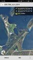
| Thu 4 Jul 2019 in 43,-79: 43.6263121, -79.3376194 geohashing.info google osm bing/os kml crox |
Location
Very near the shore in Tommy Thompson Park.
Participants
Plans
Thanks to July 4th, when we celebrate when a bunch of rich white men in Boston got angry about taxes, the coordinates were available a day early! This hashpoint looked reachable, so I set my alarm for an early departure and prepared to bike out there.
Expedition
I left my apartment at about 6:30 am and rode down to Kingston Road. From there I took Fallingbrook down to Queen, and then Silver Birch down to the trail that runs along the lake. I followed that trail out to the intersection of Leslie Street and Lakeshore, which is the location of the Leslie Barns, where all of the fancy new low-floor streetcars (Flexity Outlook model) are kept overnight.
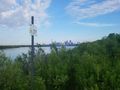
Leslie Street runs south into the "Leslie Street Spit", a bit of artificially-created land south of Leslie Street which Wikipedia points out isn't actually a spit and could be referred to by the official name "Outer Harbour East Headland", except no one actually calls it that. A good bit of the Leslie Street Spit is covered by Tommy Thompson Park, which is very pretty and has a lot of wildlife, greenery, and a nice multi-use path that was very well-used. I passed a lot of people jogging and biking. The views of downtown were gorgeous!
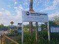
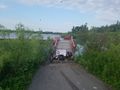
The hashpoint was past a floating bridge. Unfortunately, the bridge was closed due to the high water levels in Lake Ontario. Indeed, the bridge was deconstructed, so that even if I was feeling like being a scofflaw today I wouldn't have been able to make it.
I called the expedition off, even though there was an alternate path, for three reasons. First, I wasn't entirely sure that the other way around was open to the public -- there were signs suggesting that it wasn't, but it was unclear if the signs were referring to the entire eastern portion of the headlands or just one of the several ways to get over there. Second, this alternate road was long and appeared largely unimproved, and so it would have either been unpleasant to bike on, or have taken a very long time to walk on. Third, the aforementioned high water levels meant that the hashpoint, instead of being slightly submerged as was suggested by satellite imagery, would likely have been very underwater and quite a bit more offshore than normal.
However, I'm glad that I made the attempt! The weather was very nice that early in the day, and the views of downtown were gorgeous. I stood for a few minutes, taking in the sound of birds and the cool morning breeze, and then headed off to the office.
Photos
Leslie Barns: "The streetcars sleep here™"
Tommy Thompson Park!
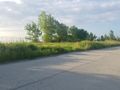
Bike path
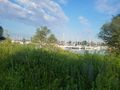
Boats
Bridge closed!
Beautiful view of downtown
This is as close as I got!


Achievements
Frogman earned the My kingdom for a boat consolation prize
|