Difference between revisions of "2019-07-07 47 -122"
imported>Thomcat (Time to check out the site) |
imported>Thomcat (Retro flags added to previous expedition) |
||
| (8 intermediate revisions by the same user not shown) | |||
| Line 1: | Line 1: | ||
| − | |||
| − | |||
| − | |||
| − | |||
| − | |||
| − | |||
| − | |||
| − | |||
| − | |||
| − | |||
{{meetup graticule | {{meetup graticule | ||
| lat=47 | | lat=47 | ||
| lon=-122 | | lon=-122 | ||
| date=2019-07-07 | | date=2019-07-07 | ||
| + | | graticule_name=Seattle | ||
| + | | graticule_link=Seattle, Washington | ||
}} | }} | ||
| Line 19: | Line 11: | ||
== Location == | == Location == | ||
| − | + | Near the junction of the Burke-Gilman Trail and Sammamish River Trail in Bothell. | |
== Participants == | == Participants == | ||
| Line 33: | Line 25: | ||
== Expedition == | == Expedition == | ||
<!-- how it all turned out. your narrative goes here. --> | <!-- how it all turned out. your narrative goes here. --> | ||
| + | === [[User:SubRosa|SubRosa]] === | ||
| + | We found it! Our first geohash : ) Am I supposed to like post a selfie taken at the site or something? | ||
| + | |||
| + | === [[User:Thomcat|Thomcat]] === | ||
| + | Parked just off highway 522 and visited the Red Brick Road park first. This is a remaining section of the first road connecting Lake Forest Park to Bothell, and eventually Seattle to Snoqualmie Pass (before any floating bridges were built). Two lanes, somewhat narrow but then older cars were pretty narrow also. | ||
| + | |||
| + | Just down the hill from here is the Burke Gilman trail. A nice tunnel leads beneath the modern road and then to a split point - Burke Gilman and a bridge to the right, Sammammish River trail (and river) to the left. | ||
| + | |||
| + | At this point, I realized my GPS was quite a ways off - perhaps from the tunnel? - and was pointing me way south of the intersection. I found a clearing near the river and waited until it reset somewhat. So exact locations on the earlier photos may not match the actual GPS coordinates :P | ||
| + | |||
| + | Now reset, I found my way back up the trail (and under the tree cover) and easily reached the spot. I looked around for any sign of a month-old marker, but saw none. | ||
| + | |||
| + | In my judgement, this was an easily reached location and, despite pictures, I think it was reached on the day in question. Marking SubRosa's expedition a success, and I hope to meet them soon. | ||
== Tracklog == | == Tracklog == | ||
| Line 42: | Line 47: | ||
--> | --> | ||
<gallery perrow="5"> | <gallery perrow="5"> | ||
| + | |||
| + | Image:2019-07-07_47_-122_thomcat_1564443020145.jpg|Red Brick Road [http://www.openstreetmap.org/?lat=47.75025580&lon=-122.21268130&zoom=16&layers=B000FTF @47.7503,-122.2127] | ||
| + | |||
| + | Image:2019-07-07_47_-122_thomcat_1564443135485.jpg|Military road marker [http://www.openstreetmap.org/?lat=47.75030240&lon=-122.21372140&zoom=16&layers=B000FTF @47.7503,-122.2137] | ||
| + | |||
| + | Image:2019-07-07_47_-122_thomcat_1564443199120.jpg|Burke Gilman tunnel [http://www.openstreetmap.org/?lat=47.75050930&lon=-122.21430350&zoom=16&layers=B000FTF @47.7505,-122.2143] | ||
| + | |||
| + | Image:2019-07-07_47_-122_thomcat_1564443372916.jpg|Intersection & bridge [http://www.openstreetmap.org/?lat=47.75028930&lon=-122.21168150&zoom=16&layers=B000FTF @47.7503,-122.2117] | ||
| + | |||
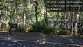
| + | Image:2019-07-07_47_-122_thomcat_1564443670353.jpg|Geohasher [http://www.openstreetmap.org/?lat=47.75059460&lon=-122.21084770&zoom=16&layers=B000FTF @47.7506,-122.2108] | ||
| + | |||
| + | Image:2019-07-07_47_-122_thomcat_1564443756156.jpg|view [http://www.openstreetmap.org/?lat=47.75064390&lon=-122.21085680&zoom=16&layers=B000FTF @47.7506,-122.2109] | ||
</gallery> | </gallery> | ||
| Line 48: | Line 65: | ||
<!-- Add any achievement ribbons you earned below, or remove this section --> | <!-- Add any achievement ribbons you earned below, or remove this section --> | ||
| − | |||
| − | |||
| − | |||
| − | |||
| − | |||
| − | |||
| − | |||
| − | |||
| − | |||
| − | |||
| − | |||
| − | |||
| − | |||
| − | |||
[[Category:Expeditions]] | [[Category:Expeditions]] | ||
| − | |||
[[Category:Expeditions with photos]] | [[Category:Expeditions with photos]] | ||
| − | |||
| − | |||
| − | |||
| − | |||
| − | |||
| − | |||
[[Category:Coordinates reached]] | [[Category:Coordinates reached]] | ||
| + | [[Category:Retro meetup]] | ||
| + | [[Category:Retro coordinates reached]] | ||
| − | + | {{location|US|WA|KN}} | |
| − | |||
| − | |||
| − | |||
| − | |||
| − | |||
| − | |||
| − | |||
| − | |||
| − | |||
| − | |||
| − | |||
| − | |||
| − | |||
| − | |||
| − | |||
Latest revision as of 13:44, 30 July 2019
| Sun 7 Jul 2019 in Seattle: 47.7506291, -122.2108833 geohashing.info google osm bing/os kml crox |
Location
Near the junction of the Burke-Gilman Trail and Sammamish River Trail in Bothell.
Participants
Plans
(Retro) Going to stop by after work and check out the site.
Expedition
SubRosa
We found it! Our first geohash : ) Am I supposed to like post a selfie taken at the site or something?
Thomcat
Parked just off highway 522 and visited the Red Brick Road park first. This is a remaining section of the first road connecting Lake Forest Park to Bothell, and eventually Seattle to Snoqualmie Pass (before any floating bridges were built). Two lanes, somewhat narrow but then older cars were pretty narrow also.
Just down the hill from here is the Burke Gilman trail. A nice tunnel leads beneath the modern road and then to a split point - Burke Gilman and a bridge to the right, Sammammish River trail (and river) to the left.
At this point, I realized my GPS was quite a ways off - perhaps from the tunnel? - and was pointing me way south of the intersection. I found a clearing near the river and waited until it reset somewhat. So exact locations on the earlier photos may not match the actual GPS coordinates :P
Now reset, I found my way back up the trail (and under the tree cover) and easily reached the spot. I looked around for any sign of a month-old marker, but saw none.
In my judgement, this was an easily reached location and, despite pictures, I think it was reached on the day in question. Marking SubRosa's expedition a success, and I hope to meet them soon.
Tracklog
Photos
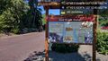
Red Brick Road @47.7503,-122.2127
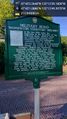
Military road marker @47.7503,-122.2137
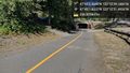
Burke Gilman tunnel @47.7505,-122.2143
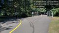
Intersection & bridge @47.7503,-122.2117

Geohasher @47.7506,-122.2108
view @47.7506,-122.2109


