Difference between revisions of "2019-07-14 52 1"
From Geohashing
imported>Sourcerer m (→New expedition) |
imported>Sourcerer m (→Photos) |
||
| Line 27: | Line 27: | ||
Image:2019-07-14_52_1_Sourcerer_1563116510216.jpg | Arrived. [http://www.openstreetmap.org/?lat=52.65737414&lon=1.31782830&zoom=16&layers=B000FTF @52.6574,1.3178] | Image:2019-07-14_52_1_Sourcerer_1563116510216.jpg | Arrived. [http://www.openstreetmap.org/?lat=52.65737414&lon=1.31782830&zoom=16&layers=B000FTF @52.6574,1.3178] | ||
Image:2019-07-14_52_1_Sourcerer_1563116526774.jpg | Street. [http://www.openstreetmap.org/?lat=52.65737414&lon=1.31782830&zoom=16&layers=B000FTF @52.6574,1.3178] | Image:2019-07-14_52_1_Sourcerer_1563116526774.jpg | Street. [http://www.openstreetmap.org/?lat=52.65737414&lon=1.31782830&zoom=16&layers=B000FTF @52.6574,1.3178] | ||
| + | Image:2019-07-14 52 1 Sourcerer.jpg | Google Earth Track | ||
</gallery> | </gallery> | ||
Revision as of 00:18, 15 July 2019
| Sun 14 Jul 2019 in Norwich: 52.6573746, 1.3178147 geohashing.info google osm bing/os kml crox |
Location
A residential street in north Norwich, Norfolk, UK.
Planning
An easy one to reach.
Participants
Expedition
Sourcerer diverted via this hashpoint after a ten mile walk with the Waveney Ramblers group. It was a drive-by hashpoint, ideal for the lazy!
Photos
- Gallery
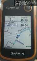
Arrived. @52.6574,1.3178

Street. @52.6574,1.3178
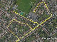
Google Earth Track


Achievements
Expeditions and Plans
| 2019-07-14 | ||
|---|---|---|
| Seattle, Washington | Thomcat, Coyotebush | On Roosevelt Way NE, just south of NE 42nd in Seattle's U-District. |
| St. Gallen, Switzerland | RecentlyChanged, a drag | In the water of Lake Constance, 1.5km away from the shore of Schloss Kirchberg... |
| Birmingham, United Kingdom | Hedgepig | Just off a footpath at Bagworth Heath, a disused colliery landscaped to mak... |
| Norwich, United Kingdom | Sourcerer | A residential street in north Norwich, Norfolk, UK. |
Sourcerer's Expedition Links
2019-05-26_52 1 - 2019-07-14_52 1 - 2019-07-15_52_1 - KML file download of Sourcerer's expeditions for use with Google Earth.