Difference between revisions of "2019-08-05 42 -85"
imported>Mcbaneg (Created page with "<!-- If you did not specify these parameters in the template, please substitute appropriate values for IMAGE, LAT, LON, and DATE (YYYY-MM-DD format) {{{image|dummy.jpg}}}|...") |
imported>FippeBot m (Location) |
||
| Line 50: | Line 50: | ||
[[Category:Expeditions with photos]] | [[Category:Expeditions with photos]] | ||
[[Category:Coordinates reached]] | [[Category:Coordinates reached]] | ||
| + | {{location|US|MI|KN}} | ||
Latest revision as of 07:42, 6 August 2019
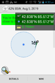
| Mon 5 Aug 2019 in 42,-85: 42.8380084, -85.6116266 geohashing.info google osm bing/os kml crox |
Location
driveway on Deer Cove Drive SE, Caledonia, MI
Participants
Expedition
I was headed to pick up my family at the airport and this was pretty close by. It was in the driveway of a house in a modern, cookie-cutter style suburban-sprawl development. The neighborhood was pleasant and comfortable but uninspired to my taste. No residents of the house were apparent outside, and I basically turned around in their driveway like a confused visitor to the neighborhood, stopping just long enough to grab the proof-shot. Low-hanging fruit, really.
This was the second time I've hit a hashpoint on my way to an airport. This one was lower risk: at worst my family would have to wait for me at baggage claim. The earlier expedition, 2015-11-15_42_-72, actually ran the risk of missing the flight...
Proof
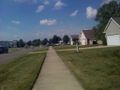
View N along Deer Cove Dr

Grin


