Difference between revisions of "2019-09-20 52 10"
From Geohashing
(new report) |
(expedition report for Schladen-Hornburg) |
||
| Line 1: | Line 1: | ||
| − | + | {{meetup graticule | |
| + | | lat=52 | ||
| + | | lon=10 | ||
| + | | date=2019-09-20 | ||
| + | }} | ||
| − | |||
| − | |||
| − | |||
| − | |||
| − | |||
| − | |||
| − | |||
| − | |||
| − | |||
| − | |||
| − | |||
__NOTOC__ | __NOTOC__ | ||
== Location == | == Location == | ||
| − | + | ||
| + | The hash lay in the alley Zissickenwinkel in Hornburg. | ||
== Participants == | == Participants == | ||
| − | + | ||
| − | + | [[User:GeorgDerReisende|GeorgDerReisende]] | |
== Plans == | == Plans == | ||
| − | + | ||
| + | Traveling by public transport to Hornburg, walking around the village and to the hash. | ||
== Expedition == | == Expedition == | ||
| − | + | ||
| + | As planned. Nothing special. | ||
== Tracklog == | == Tracklog == | ||
| − | + | ||
| + | During the [[Dark Ages]] I logged all expeditions by contributing to [https://commons.wikimedia.org/wiki/User:GeorgDerReisende/geohashing Wikimedia Commons]. View all photos of this expedition [https://commons.wikimedia.org/wiki/Category:Files_by_User:GeorgDerReisende/20190920 here]. | ||
== Photos == | == Photos == | ||
| − | < | + | |
| − | + | <gallery> | |
| − | -- | + | File:2019-09-20 52 10 GeorgDerReisende 1133.jpg | arrived |
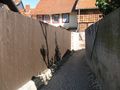
| − | + | File:2019-09-20 52 10 GeorgDerReisende 1218.jpg | entrance to the alley from the New Street | |
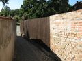
| + | File:2019-09-20 52 10 GeorgDerReisende 1230.jpg | this is the allex | ||
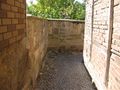
| + | File:2019-09-20 52 10 GeorgDerReisende 1231.jpg | location of the hash | ||
| + | File:2019-09-20 52 10 GeorgDerReisende 1232.jpg | from the other side | ||
| + | File:2019-09-20 52 10 GeorgDerReisende 1233.jpg | the geohasher | ||
| + | File:2019-09-20 52 10 GeorgDerReisende 1235.jpg | general view from the west | ||
</gallery> | </gallery> | ||
| Line 40: | Line 42: | ||
<!-- Add any achievement ribbons you earned below, or remove this section --> | <!-- Add any achievement ribbons you earned below, or remove this section --> | ||
| − | + | {{Dark Ages | latitude = 52 | longitude = 10 | date = 2019-09-20 | name = GeorgDerReisende }} | |
| − | |||
| − | |||
| − | + | [[Category:Expeditions]] | |
| − | + | [[Category:Expeditions with photos]] | |
| − | |||
| − | [[Category: | ||
| − | |||
| − | + | [[Category:Expedition without GPS]] | |
| − | |||
| − | |||
| − | |||
| − | |||
| − | |||
| − | |||
| − | |||
| − | |||
| − | |||
[[Category:Coordinates reached]] | [[Category:Coordinates reached]] | ||
| − | |||
| − | |||
| − | |||
| − | |||
| − | |||
| − | |||
| − | |||
| − | |||
| − | |||
| − | |||
| − | |||
| − | |||
| − | |||
| − | |||
| − | |||
| − | |||
| − | |||
| − | |||
Revision as of 10:52, 5 April 2020
| Fri 20 Sep 2019 in 52,10: 52.0277876, 10.6029215 geohashing.info google osm bing/os kml crox |
Location
The hash lay in the alley Zissickenwinkel in Hornburg.
Participants
Plans
Traveling by public transport to Hornburg, walking around the village and to the hash.
Expedition
As planned. Nothing special.
Tracklog
During the Dark Ages I logged all expeditions by contributing to Wikimedia Commons. View all photos of this expedition here.
Photos
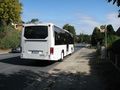
arrived
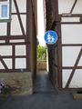
entrance to the alley from the New Street
this is the allex
location of the hash
from the other side
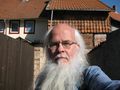
the geohasher
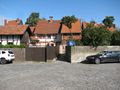
general view from the west


Achievements

GeorgDerReisende earned the Dark Ages achievement
by going on an expedition to the (52, 10) geohash on 2019-09-20.