Difference between revisions of "2020-01-09 33 -13"
From Geohashing
(Created page with "{{meetup graticule | lat=33 | lon=-13 | date=2020-01-09 }} __NOTOC__ == Location == An ocean hashpoint. == Planning == Long distance flight boredom - see if we overfly a h...") |
m (→Photos) |
||
| Line 23: | Line 23: | ||
<gallery caption="Gallery" widths="200px" heights="200px" perrow="3"> | <gallery caption="Gallery" widths="200px" heights="200px" perrow="3"> | ||
Image:2020-01-09_33_-13_Proof_Sourcerer.jpg | Proof | Image:2020-01-09_33_-13_Proof_Sourcerer.jpg | Proof | ||
| + | Image:2020-01-09_33_-13_Google_Sourcerer.jpg | Google Earth | ||
</gallery> | </gallery> | ||
Revision as of 18:06, 18 February 2020
| Thu 9 Jan 2020 in 33,-13: 33.7372300, -13.3772246 geohashing.info google osm bing/os kml crox |
Location
An ocean hashpoint.
Planning
Long distance flight boredom - see if we overfly a hashpoint.
Participants
Expedition
Photos
- Gallery
Proof
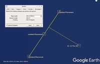
Google Earth


Achievements
Expeditions and Plans
| 2020-01-09 | ||
|---|---|---|
| Atlantic Ocean 33, -13, Atlantic Ocean | Sourcerer | An ocean hashpoint about 340 km east of Funchal, Madeira, Atlantic Ocean. |
Sourcerer's Expedition Links
2019-07-14_52 1 - 2020-01-09_33_-13 - 2020-02-19_52 1 - KML file download of Sourcerer's expeditions for use with Google Earth.