Difference between revisions of "2020-02-06 51 10"
From Geohashing
(new report) |
(expedition report for Stapelburg) |
||
| Line 1: | Line 1: | ||
| − | + | {{meetup graticule | |
| − | |||
| − | |||
| − | |||
| − | |||
| − | |||
| − | |||
| − | |||
| − | |||
| lat={{#explode:{{SUBPAGENAME}}| |1}} | | lat={{#explode:{{SUBPAGENAME}}| |1}} | ||
| lon={{#explode:{{SUBPAGENAME}}| |2}} | | lon={{#explode:{{SUBPAGENAME}}| |2}} | ||
| date={{#explode:{{SUBPAGENAME}}| |0}} | | date={{#explode:{{SUBPAGENAME}}| |0}} | ||
| − | }} | + | }} |
| + | |||
__NOTOC__ | __NOTOC__ | ||
== Location == | == Location == | ||
| − | + | ||
| + | The hash lay on the state road between Ilsenburg and Stapelburg. | ||
== Participants == | == Participants == | ||
| − | + | ||
| − | + | [[User:GeorgDerReisende|GeorgDerReisende]] | |
== Plans == | == Plans == | ||
| − | + | ||
| + | The plan was to travel to Ilsenburg, waiting there for the bus to Bad Harzburg, taking this bus and while sitting in the bus passing the hash. | ||
== Expedition == | == Expedition == | ||
| − | + | ||
| + | Like the plan. Therefor I couldn't take a photo of the exact spot, I only got three photos out of the window. Before the hash, about there and after the hash. | ||
== Tracklog == | == Tracklog == | ||
| − | + | ||
| + | During the [[Dark Ages]] I logged all expeditions by contributing to [https://commons.wikimedia.org/wiki/User:GeorgDerReisende/geohashing Wikimedia Commons]. View all photos of this expedition [https://commons.wikimedia.org/wiki/Category:Files_by_User:GeorgDerReisende/20200206 here]. | ||
== Photos == | == Photos == | ||
| − | < | + | |
| − | + | <gallery> | |
| − | -- | + | File:2020-02-06 51 10 GeorgDerReisende 4209.jpg | before the hash |
| − | + | File:2020-02-06 51 10 GeorgDerReisende 4210.jpg | shortly before | |
| + | File:2020-02-06 51 10 GeorgDerReisende 4211.jpg | shortly after | ||
</gallery> | </gallery> | ||
| − | + | [[Category:Expeditions]] | |
| − | |||
| − | |||
| − | + | [[Category:Expeditions with photos]] | |
| − | |||
| − | [[Category: | ||
| − | + | [[Category:Expedition without GPS]] | |
| − | |||
| − | |||
| − | |||
| − | [[Category:Expedition | ||
| − | |||
| − | |||
| − | |||
| − | |||
| − | |||
| − | |||
| − | |||
| − | |||
| − | |||
| − | |||
| − | |||
| − | |||
[[Category:Coordinates reached]] | [[Category:Coordinates reached]] | ||
| − | |||
| − | |||
| − | |||
| − | |||
| − | |||
| − | |||
| − | |||
| − | |||
| − | |||
| − | |||
| − | |||
| − | |||
| − | |||
| − | |||
| − | |||
| − | |||
| − | |||
| − | |||
Revision as of 19:37, 29 June 2020
| Thu 6 Feb 2020 in 51,10: 51.8876080, 10.6731899 geohashing.info google osm bing/os kml crox |
Location
The hash lay on the state road between Ilsenburg and Stapelburg.
Participants
Plans
The plan was to travel to Ilsenburg, waiting there for the bus to Bad Harzburg, taking this bus and while sitting in the bus passing the hash.
Expedition
Like the plan. Therefor I couldn't take a photo of the exact spot, I only got three photos out of the window. Before the hash, about there and after the hash.
Tracklog
During the Dark Ages I logged all expeditions by contributing to Wikimedia Commons. View all photos of this expedition here.
Photos
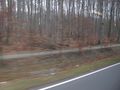
before the hash
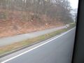
shortly before
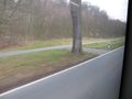
shortly after


