Difference between revisions of "2020-02-16 53 9"
m (clearing up username confusion) |
(→Photos: photos 40) |
||
| Line 12: | Line 12: | ||
==Photos== | ==Photos== | ||
| − | + | <gallery> | |
| − | <gallery | + | File:2020-02-16 53 9 6.png | proof 1 |
| + | File:2020-02-16 53 9 7.png | proof 2 | ||
| + | File:2020-02-16 53 9 1.jpg | the hash | ||
| + | File:2020-02-16 53 9 2.jpg | pano 1 | ||
| + | File:2020-02-16 53 9 3.jpg | pano 2 | ||
| + | File:2020-02-16 53 9 4.jpg | π π π | ||
| + | File:2020-02-16 53 9 5.jpg | other direction, family in background | ||
</gallery> | </gallery> | ||
Latest revision as of 16:32, 16 January 2022
| Sun 16 Feb 2020 in 53,9: 53.6834008, 9.9805895 geohashing.info google osm bing/os kml crox |
Location
next to a path in a residential area in Norderstedt-Garstedt, Schleswig-Holstein, directly between two houses
Participants
Expedition
π π π (log from April 2020)
I took the train to Garstedt and cycled the last 600 m. But when I got to where I wanted to enter the residential area, I only found a giant closed construction site. So I went around the street and tried from the other side, which worked. The hash lay on mossy ground 4 m next to a paved path, 5 and 8 m from respective houses on other sides. I spent several minutes doing my hashdance, which must have confused a mother who was playing football with her toddler only 10 m away. But I felt comfortable as this was public ground. The sun had already set a few minutes prior, so I took some dark pictures and rode back. But as I looked up the train times, I noticed it would take just as long to bike home as to take the train. So I decided to cycle the 14 km, taking a wrong turn but still arriving just before I would have, had I taken the train.
Photos

proof 1

proof 2
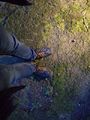
the hash
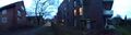
pano 1
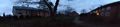
pano 2
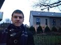
π π π

other direction, family in background


Achievements
Land geohash, Bicycle geohash, Public transport geohash
π π π earned the Last man standing achievement
|