Difference between revisions of "2020-03-20 50 -0"
Macronencer (talk | contribs) (→Tracklog: Add tracklog) |
Macronencer (talk | contribs) (→Photos: Add gallery photos) |
||
| Line 40: | Line 40: | ||
--> | --> | ||
<gallery perrow="5"> | <gallery perrow="5"> | ||
| + | Image:2020-03-20 50 -0 Macronencer 01 Hash on map.png | The hash point on the map | ||
| + | Image:2020-03-20 50 -0 Macronencer 02 Hash from orbit.png | The hash point from orbit | ||
| + | Image:2020-03-20 50 -0 Macronencer 03 Magnums.jpg | My trusty Magnum boots, as worn by British coppers. Too leaky to use at the moment! | ||
| + | Image:2020-03-20 50 -0 Macronencer 04 A27 drive.png | The drive to the hash | ||
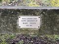
| + | Image:2020-03-20 50 -0 Macronencer 05 Memorial bench.jpg | Another memorial bench. I like finding these! | ||
| + | Image:2020-03-20 50 -0 Macronencer 06 Mike Seeley.jpg | Mike Seeley | ||
| + | Image:2020-03-20 50 -0 Macronencer 07 Setting off.jpg | Off along the forest path! | ||
| + | Image:2020-03-20 50 -0 Macronencer 08 Alternative car park.jpg | This is the other car park I might have used. But then I wouldn't have walked so far and got such good exercise. | ||
| + | Image:2020-03-20 50 -0 Macronencer 09 Bridleway sign.jpg | Yes, it's a bridleway. I can go up there! | ||
| + | Image:2020-03-20 50 -0 Macronencer 10 Down and up.jpg | The bridleway cuts across a valley. Quite steep hills. | ||
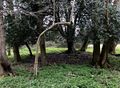
| + | Image:2020-03-20 50 -0 Macronencer 11 Telescopic tree.jpg | Telescope Tree... | ||
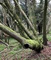
| + | Image:2020-03-20 50 -0 Macronencer 12 Den.jpg | Who lives in here? It's spoooky. | ||
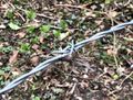
| + | Image:2020-03-20 50 -0 Macronencer 13 Not quite.jpg | Damn. Thwarted by the barbed wire fence. | ||
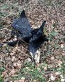
| + | Image:2020-03-20 50 -0 Macronencer 14 Badger or boar.jpg | Talking of barbed wire, this looks like badger hair but is a long way off the ground. Perhaps it's wild boar? | ||
| + | Image:2020-03-20 50 -0 Macronencer 15 Got it.jpg | Finally, I'm inside the accuracy radius! | ||
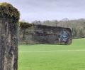
| + | Image:2020-03-20 50 -0 Macronencer 16 The hash point.jpg | The hash point is a bit boring | ||
| + | Image:2020-03-20 50 -0 Macronencer 17 Chuck at the hash.jpg | Chuck at the hash point | ||
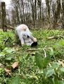
| + | Image:2020-03-20 50 -0 Macronencer 18 Chuck and me.jpg | Chuck and me at the hash point | ||
| + | Image:2020-03-20 50 -0 Macronencer 19 Pano from hash.jpg | A panorama taken from the corner of the field | ||
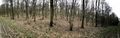
| + | Image:2020-03-20 50 -0 Macronencer 20 Woodland on way back.jpg | It was a very atmospheric wood | ||
| + | Image:2020-03-20 50 -0 Macronencer 21 Woodland pano.jpg | Imagine a gentle breeze, and no traffic sound at all... | ||
| + | Image:2020-03-20 50 -0 Macronencer 22 Burnt stump.jpg | Burnt stump | ||
</gallery> | </gallery> | ||
Revision as of 21:50, 20 March 2020
| Fri 20 Mar 2020 in 50,-0: 50.9116007, -0.6835986 geohashing.info google osm bing/os kml crox |
Location
Oxen Down, East Dean, Chichester
Participants
Plans
Macronencer (talk) is planning to visit this, as it looks to be near a path and hopefully all right to access. It's also one of two possible hashes this day, so going for a multihash.
Car Parks
- 50.9063311,-0.6864138 = Droke Forest forestry commission car park is closer, but looks pretty small and could perhaps be closed in the winter season.
- 50.8991019,-0.6841273 = Selhurstpark Road is larger, more likely to be open, and also a longer distance away so a better walk.
Expedition
Co-ordinates reached. Full report coming soon!
Tracklog
Photos
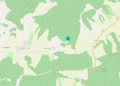
The hash point on the map
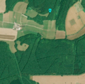
The hash point from orbit
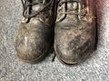
My trusty Magnum boots, as worn by British coppers. Too leaky to use at the moment!

The drive to the hash
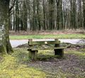
Another memorial bench. I like finding these!
Mike Seeley
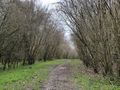
Off along the forest path!
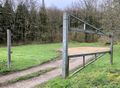
This is the other car park I might have used. But then I wouldn't have walked so far and got such good exercise.
Yes, it's a bridleway. I can go up there!
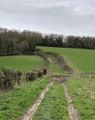
The bridleway cuts across a valley. Quite steep hills.
Telescope Tree...
Who lives in here? It's spoooky.

Damn. Thwarted by the barbed wire fence.
Talking of barbed wire, this looks like badger hair but is a long way off the ground. Perhaps it's wild boar?

Finally, I'm inside the accuracy radius!
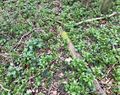
The hash point is a bit boring
Chuck at the hash point

Chuck and me at the hash point
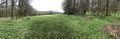
A panorama taken from the corner of the field
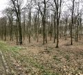
It was a very atmospheric wood
Imagine a gentle breeze, and no traffic sound at all...
Burnt stump


Achievements