Difference between revisions of "2020-03-21 52 9"
(New Plans) |
(Report) |
||
| Line 16: | Line 16: | ||
I am planning to take the bike there. If someone else shows up: Let's keep our distance. Should Lower Saxony be under curfew by then, I won't go of course. | I am planning to take the bike there. If someone else shows up: Let's keep our distance. Should Lower Saxony be under curfew by then, I won't go of course. | ||
| + | ==Expedition== | ||
| + | I took the bike there. There were people outside, but fortunately everyone I saw was keeping their distance. Eventually, I arrived at the forest. | ||
| + | |||
| + | Shortly before I arrived at the part of the forest path where I needed to get into the forest for a few meters, there were some people, so I passed them and went back afterwards. I reached the coordinates and recorded proof. When I left the forest, there were some other people, but they did not ask any questions. | ||
| + | |||
| + | Afterwards, I rode the bike back home. | ||
| + | |||
| + | ==Photos== | ||
| + | <gallery> | ||
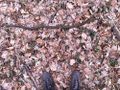
| + | 2020-03-21 52 09 01 Proof.jpg | Proof | ||
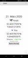
| + | 2020-03-21 52 09 02 Geohash.jpg | The Geohash | ||
| + | 2020-03-21 52 09 03 Surroundings.jpg | Surroundings | ||
| + | 2020-03-21 52 09 04 Surroundings.jpg | Surroundings | ||
| + | 2020-03-21 52 09 05 Surroundings.jpg | Surroundings | ||
| + | 2020-03-21 52 09 06 Surroundings.jpg | Surroundings | ||
| + | 2020-03-21 52 09 07 Path.jpg | The bicycle on the forest path | ||
| + | 2020-03-21 52 09 08 Blauer See.jpg | Near the ''Blue Lake'' | ||
| + | </gallery> | ||
| + | |||
| + | ==Ribbons== | ||
| + | {{#vardefine:ribbonwidth|100%}} | ||
| + | {{land geohash|latitude=52|longitude=9|date=2020-03-21|name=[[User:Fippe|Fippe]]|image=2020-03-21 52 09 02 Geohash.jpg}} | ||
| + | {{bicycle geohash|latitude=52|longitude=9|date=2020-03-21|name=[[User:Fippe|Fippe]]|distance=19km|bothways=true|image=2020-03-21 52 09 07 Path.jpg}} | ||
| + | {{xkcd centurion|count=8|name=[[User:Fippe|Fippe]]}} | ||
| + | |||
| + | __NOTOC__ | ||
| + | [[Category:Expeditions]] | ||
| + | [[Category:Coordinates reached]] | ||
| + | [[Category:Expeditions with photos]] | ||
{{location|DE|NI|H}} | {{location|DE|NI|H}} | ||
| − | [[Category: | + | [[Category:Expeditions by Fippe]] |
Revision as of 16:22, 21 March 2020
| Sat 21 Mar 2020 in Hannover: 52.4057796, 9.8441214 geohashing.info google osm bing/os kml crox |
Location
This Geohash is located in a forest in Hannover-Misburg.
Participants
Plans
I am planning to take the bike there. If someone else shows up: Let's keep our distance. Should Lower Saxony be under curfew by then, I won't go of course.
Expedition
I took the bike there. There were people outside, but fortunately everyone I saw was keeping their distance. Eventually, I arrived at the forest.
Shortly before I arrived at the part of the forest path where I needed to get into the forest for a few meters, there were some people, so I passed them and went back afterwards. I reached the coordinates and recorded proof. When I left the forest, there were some other people, but they did not ask any questions.
Afterwards, I rode the bike back home.
Photos
Proof
The Geohash
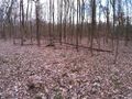
Surroundings
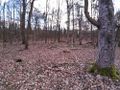
Surroundings
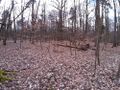
Surroundings
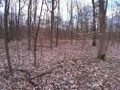
Surroundings
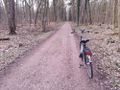
The bicycle on the forest path
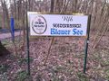
Near the Blue Lake


Ribbons
Fippe earned the Land geohash achievement
|
Fippe earned the Bicycle geohash achievement
|
Fippe earned the xkcd Nullaturion achievement
|