Difference between revisions of "2020-03-25 43 -72"
m (Location) |
m (→Expedition: Fixed typo) |
||
| (4 intermediate revisions by the same user not shown) | |||
| Line 6: | Line 6: | ||
|graticule_link = 43,-72 | |graticule_link = 43,-72 | ||
}} | }} | ||
| − | |||
== Plans == | == Plans == | ||
It's only about 15 miles from me and right by a road, so I plan to bicycle unless family members want to come who'd rather drive. | It's only about 15 miles from me and right by a road, so I plan to bicycle unless family members want to come who'd rather drive. | ||
I expect to be there at around 1:00pm | I expect to be there at around 1:00pm | ||
| + | |||
| + | == Location == | ||
| + | A couple miles north of Newport. | ||
| + | |||
| + | == Participants == | ||
| + | [[User:Odysseus|Odysseus]] | ||
| + | |||
| + | == Expedition == | ||
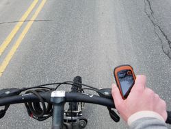
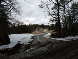
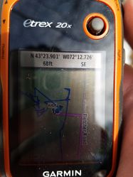
| + | I set off at 12:40pm and biked 15.2 miles to the hash. Most of the journey was on a major road, but near the end I was on a very peaceful road with a covered bridge and lots of nice houses. I was very tired by the time I got there and decided to call a ride home, as it had taken longer to get there than I thought. The hash was only 20ft or so off the road, so the only hard part was the biking. I biked 3 or so miles back to Newport where I suddenly got a flat front tire! Luckily, I met my ride home a few minutes later. | ||
| + | |||
| + | == Photos == | ||
| + | <gallery caption="Photo Gallery" widths="250px" heights="250px" perrow="3"> | ||
| + | Image:20200325_140458.jpg|The setup | ||
| + | Image:20200325 144800.jpg|Wacky yellow house | ||
| + | Image:20200325 140536.jpg|Nice covered bridge | ||
| + | Image:20200325 143953.jpg|Made it | ||
| + | Image:20200325 142451.jpg|Parking spot | ||
| + | Image:20200325 143255.jpg|Proof | ||
| + | Image:20200325 142625.jpg|My biking stats on arrival | ||
| + | Image:20200325_142557.jpg|The geohash itself! | ||
| + | Image:20200325path.jpg|My path on the way there | ||
| + | </gallery> | ||
| + | |||
| + | == Achievements == | ||
| + | {{bicycle geohash | ||
| + | |||
| + | | latitude = 43 | ||
| + | | longitude = -72 | ||
| + | | date = 2020-03-25 | ||
| + | | name = Odysseus | ||
| + | | distance = 18 miles | ||
| + | | bothways = false | ||
| + | | image = 20200325 143953.jpg | ||
| + | }} | ||
| + | |||
| + | [[Category:Expeditions]] | ||
| + | [[Category:Expeditions with photos]] | ||
| + | [[Category:Coordinates reached]] | ||
{{location|US|NH|SU}} | {{location|US|NH|SU}} | ||
Latest revision as of 01:54, 13 May 2020
| Wed 25 Mar 2020 in Claremont: 43.3984961, -72.2122568 geohashing.info google osm bing/os kml crox |
Plans
It's only about 15 miles from me and right by a road, so I plan to bicycle unless family members want to come who'd rather drive.
I expect to be there at around 1:00pm
Location
A couple miles north of Newport.
Participants
Expedition
I set off at 12:40pm and biked 15.2 miles to the hash. Most of the journey was on a major road, but near the end I was on a very peaceful road with a covered bridge and lots of nice houses. I was very tired by the time I got there and decided to call a ride home, as it had taken longer to get there than I thought. The hash was only 20ft or so off the road, so the only hard part was the biking. I biked 3 or so miles back to Newport where I suddenly got a flat front tire! Luckily, I met my ride home a few minutes later.
Photos
- Photo Gallery
The setup
Wacky yellow house
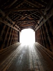
Nice covered bridge

Made it
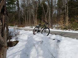
Parking spot
Proof
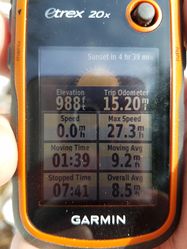
My biking stats on arrival
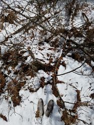
The geohash itself!
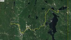
My path on the way there


Achievements
Odysseus earned the Bicycle geohash achievement
|