Difference between revisions of "2020-03-28 48 11"
Clearlucid9 (talk | contribs) ([live picture]My bike parked close to the hash) |
m (Location) |
||
| (7 intermediate revisions by 2 users not shown) | |||
| Line 1: | Line 1: | ||
| − | + | {{meetup graticule | |
| − | |||
| − | |||
| − | |||
| − | |||
| − | |||
| − | |||
| − | |||
| − | |||
| lat=48 | | lat=48 | ||
| lon=11 | | lon=11 | ||
| date=2020-03-28 | | date=2020-03-28 | ||
| − | }} | + | }} |
__NOTOC__ | __NOTOC__ | ||
== Location == | == Location == | ||
| − | + | in the middle of a field just outside of Harthausen, south east of Munich | |
== Participants == | == Participants == | ||
| − | + | [[User:Clearlucid9|Clearlucid9]] ([[User talk:Clearlucid9|talk]]) | |
| − | |||
| − | |||
| − | |||
| − | |||
== Expedition == | == Expedition == | ||
| − | + | With the social distancing restrictions in place we are only allowed to leave the house for food shopping, a walk or other outside sport activity as long as you do that alone. Hence I did not have high hopes to get to a hash these days, but when I saw the hash location last night I calculated that I would be able to get there by bike (13 km one way). To minimise the risk of meeting anyone (also I never have at a hash so far), I left the house early at 7.10 a.m. and got to the cache in under 45 minutes (I know - I am not very fast on the push bike...). The field had been freshly prepared for the new crops, so I was concerned to anger the farmer. But as the crops hadn't started to come out yet, I think I didn't cause any damage. Being out in the open it's been possible to get VERY close to the posted coordinates (new record for me I think). | |
| − | + | I rode back a slightly different way and was back before the family had breakfast. On the way back I saw various bakeries with long | |
| − | + | queues - due to the fact that they limit the number of customers allowed to be inside at any time and the 1,5m distance rule in the queue outside. Crazy times! | |
| − | |||
== Photos == | == Photos == | ||
| − | |||
| − | |||
| − | |||
<gallery perrow="5"> | <gallery perrow="5"> | ||
| Line 48: | Line 32: | ||
== Achievements == | == Achievements == | ||
{{#vardefine:ribbonwidth|800px}} | {{#vardefine:ribbonwidth|800px}} | ||
| − | + | {{Earliest geohasher | |
| − | + | | latitude = 48 | |
| − | + | | longitude = 11 | |
| − | + | | date = 2020-03-28 | |
| + | | name = Clearlucid9 | ||
| − | |||
| − | + | }} | |
| − | |||
| − | |||
| − | |||
| − | + | {{bicycle geohash | |
| + | |||
| + | | latitude = 48 | ||
| + | | longitude = 11 | ||
| + | | date = 2020-03-28 | ||
| + | | name = Clearlucid9 | ||
| + | | distance = 13 km | ||
| + | | bothways = true | ||
| + | |||
| + | }} | ||
| − | |||
[[Category:Expeditions]] | [[Category:Expeditions]] | ||
| − | |||
[[Category:Expeditions with photos]] | [[Category:Expeditions with photos]] | ||
| − | |||
| − | |||
| − | |||
| − | |||
| − | |||
[[Category:Coordinates reached]] | [[Category:Coordinates reached]] | ||
| − | + | {{location|DE|BY|M}} | |
| − | |||
| − | |||
| − | |||
| − | |||
| − | |||
| − | |||
| − | |||
| − | |||
| − | |||
| − | |||
| − | |||
| − | |||
| − | |||
| − | |||
| − | |||
| − | |||
| − | |||
Latest revision as of 22:42, 10 April 2020
| Sat 28 Mar 2020 in 48,11: 48.0579727, 11.7826840 geohashing.info google osm bing/os kml crox |
Location
in the middle of a field just outside of Harthausen, south east of Munich
Participants
Expedition
With the social distancing restrictions in place we are only allowed to leave the house for food shopping, a walk or other outside sport activity as long as you do that alone. Hence I did not have high hopes to get to a hash these days, but when I saw the hash location last night I calculated that I would be able to get there by bike (13 km one way). To minimise the risk of meeting anyone (also I never have at a hash so far), I left the house early at 7.10 a.m. and got to the cache in under 45 minutes (I know - I am not very fast on the push bike...). The field had been freshly prepared for the new crops, so I was concerned to anger the farmer. But as the crops hadn't started to come out yet, I think I didn't cause any damage. Being out in the open it's been possible to get VERY close to the posted coordinates (new record for me I think). I rode back a slightly different way and was back before the family had breakfast. On the way back I saw various bakeries with long queues - due to the fact that they limit the number of customers allowed to be inside at any time and the 1,5m distance rule in the queue outside. Crazy times!
Photos

Logproof
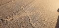
X marks the spot
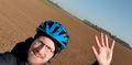
Me @ the hash
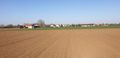
Looking back to the village
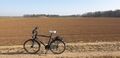
My bike parked close to the hash
Achievements
Clearlucid9 earned the Earliest geohasher achievement
|
Clearlucid9 earned the Bicycle geohash achievement
|