Difference between revisions of "2020-04-12 49 8"
(An expedition message sent via Geohash Droid for Android.) |
m (Location) |
||
| (5 intermediate revisions by one other user not shown) | |||
| Line 1: | Line 1: | ||
| − | + | {{meetup graticule | |
| − | |||
| − | |||
| − | |||
| − | |||
| − | |||
| − | |||
| − | |||
| − | |||
| lat=49 | | lat=49 | ||
| lon=8 | | lon=8 | ||
| Line 15: | Line 7: | ||
== Location == | == Location == | ||
<!-- where you've surveyed the hash to be --> | <!-- where you've surveyed the hash to be --> | ||
| + | Another field. Near Winden this time. | ||
== Participants == | == Participants == | ||
<!-- who attended: If you link to your wiki user name in this section, your expedition will be picked up by the various statistics generated for geohashing. You may use three tildes ~ as a shortcut to automatically insert the user signature of the account you are editing with. | <!-- who attended: If you link to your wiki user name in this section, your expedition will be picked up by the various statistics generated for geohashing. You may use three tildes ~ as a shortcut to automatically insert the user signature of the account you are editing with. | ||
--> | --> | ||
| + | [[User:DODO|DODO]] | ||
== Plans == | == Plans == | ||
<!-- what were the original plans --> | <!-- what were the original plans --> | ||
| − | + | From the four easter-hasghes this year was only one close enough, so that I just could rech it with my bull. And so I had to go today. | |
== Expedition == | == Expedition == | ||
<!-- how it all turned out. your narrative goes here. --> | <!-- how it all turned out. your narrative goes here. --> | ||
| + | I started after breakfast at half past ten. The weather still sunny and very warm. Once again there were many blossoms and perfumes but you can' recognize them on the bike as well as by foot. And you can't take many pictures. | ||
| + | |||
| + | I reached the hashfield some minutes after 12. Some people were working in a greenhouse on the other side of the road. I had to go 20 m into the field. I didn't want to arrest attention, so I just took some pictures, walked back to the bull and continued my ride. So I reached home again at 2 pm after an 80 KM ride. Short time later some rain was falling, so I was happy that I started that early. | ||
| + | |||
| + | This time I managed to do a perfect tron. | ||
== Tracklog == | == Tracklog == | ||
<!-- if your GPS device keeps a log, you may post a link here --> | <!-- if your GPS device keeps a log, you may post a link here --> | ||
| + | [https://www.komoot.de/tour/170063503 84 KM by bull] | ||
== Photos == | == Photos == | ||
| Line 33: | Line 33: | ||
Image:2020-##-## ## ## Alpha.jpg | Witty Comment | Image:2020-##-## ## ## Alpha.jpg | Witty Comment | ||
--> | --> | ||
| − | <gallery perrow=" | + | <gallery perrow="6"> |
| + | Image:2020-04-12_49_8_DODO_1586686805982.jpg|proof | ||
| + | File:IMG_20200412_121827.jpg|north | ||
| + | File:IMG_20200412_121829.jpg|west | ||
| + | File:IMG_20200412_121831.jpg|south | ||
| + | File:IMG_20200412_121834.jpg|east | ||
| + | Image:2020-04-12_49_8_DODO_1586686831066.jpg|Stupid grin | ||
</gallery> | </gallery> | ||
| Line 39: | Line 45: | ||
{{#vardefine:ribbonwidth|800px}} | {{#vardefine:ribbonwidth|800px}} | ||
<!-- Add any achievement ribbons you earned below, or remove this section --> | <!-- Add any achievement ribbons you earned below, or remove this section --> | ||
| + | {{land geohash | ||
| + | | latitude = 49 | ||
| + | | longitude =8 | ||
| + | | date = 2020-04-12 | ||
| + | | name = DODO | ||
| + | }} | ||
| − | + | {{Template:Tron | |
| − | + | | latitude = 49 | |
| − | + | | longitude = 8 | |
| − | + | | date = 2020-04-12 | |
| − | + | | name = DODO | |
| + | | tracklog = https://www.komoot.de/tour/170063503 | ||
| + | | possessive = his | ||
| + | }} | ||
| − | |||
| − | |||
| − | |||
| − | |||
| − | |||
| − | |||
| − | |||
| − | |||
[[Category:Expeditions]] | [[Category:Expeditions]] | ||
| − | |||
| − | |||
| − | |||
| − | |||
| − | |||
| − | |||
| − | |||
[[Category:Coordinates reached]] | [[Category:Coordinates reached]] | ||
| − | + | {{location|DE|RP|GER}} | |
| − | |||
| − | |||
| − | |||
| − | |||
| − | |||
| − | |||
| − | |||
| − | |||
| − | |||
| − | |||
| − | |||
| − | |||
| − | |||
| − | |||
| − | |||
| − | |||
| − | |||
Latest revision as of 17:42, 12 April 2020
| Sun 12 Apr 2020 in 49,8: 49.1107284, 8.1226240 geohashing.info google osm bing/os kml crox |
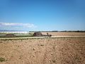
Location
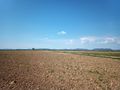
Another field. Near Winden this time.
Participants
Plans
From the four easter-hasghes this year was only one close enough, so that I just could rech it with my bull. And so I had to go today.
Expedition
I started after breakfast at half past ten. The weather still sunny and very warm. Once again there were many blossoms and perfumes but you can' recognize them on the bike as well as by foot. And you can't take many pictures.
I reached the hashfield some minutes after 12. Some people were working in a greenhouse on the other side of the road. I had to go 20 m into the field. I didn't want to arrest attention, so I just took some pictures, walked back to the bull and continued my ride. So I reached home again at 2 pm after an 80 KM ride. Short time later some rain was falling, so I was happy that I started that early.
This time I managed to do a perfect tron.
Tracklog
Photos
proof
north
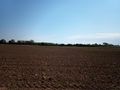
west
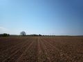
south
east
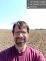
Stupid grin


Achievements
DODO earned the Land geohash achievement
|
DODO earned the Tron achievement
|