Difference between revisions of "2020-04-16 -37 145"
Felix Dance (talk | contribs) ([live picture]Hash location [https://openstreetmap.org/?lat=-37.86395060&lon=145.01440800&zoom=16&layers=B000FTF @-37.8640,145.0144]) |
m (More specific location) |
||
| (6 intermediate revisions by 2 users not shown) | |||
| Line 1: | Line 1: | ||
| − | + | [[Image:{{{IMAGE|2020-04-16_-37_145_Felix Dance_1587026447884.jpg}}}|thumb|left]] | |
| − | + | {{meetup graticule | |
| − | |||
| − | |||
| − | |||
| − | |||
| − | |||
| − | |||
| lat=-37 | | lat=-37 | ||
| lon=145 | | lon=145 | ||
| date=2020-04-16 | | date=2020-04-16 | ||
| − | }} | + | }} |
| − | + | ||
== Location == | == Location == | ||
| − | + | On a grassy nature strip in Caulfield North. | |
== Participants == | == Participants == | ||
| − | + | *[[USer:Felix Dance|Felix Dance]] | |
| − | + | ||
| + | == Expedition == | ||
| + | This was a basic one. I checked the hashes after work at 5pm and realised it was doable. Actually, I was only checking to write-up the previous day's [[2020-04-15 -37 144|hash]] and lucky I did! | ||
| + | |||
| + | So I quickly jumped on my road bike, road down Moonee Ponds Creek, the Docklands, Pick Street and the bayside Esplanade, then up Fitzroy street and east to... well you can just look at the Strava route below. | ||
| − | + | I got to the hash, got the GPS to within 256mm (pretty goood!) and headed home. I wanted to do a Tron achievement but accidentally rode up a one-way street and messed it up. | |
| − | |||
| − | + | The way back was a breeze riding along the Yarra and through the city. I stopped on the way home in North Melbourne for a kebab for dinner. | |
| − | |||
| − | + | I wonder if I'll get a third consecutive day! | |
| − | |||
== Photos == | == Photos == | ||
| − | |||
| − | |||
| − | |||
<gallery perrow="5"> | <gallery perrow="5"> | ||
| − | |||
Image:2020-04-16_-37_145_Felix Dance_1587026421170.jpg|Hash location [https://openstreetmap.org/?lat=-37.86395060&lon=145.01440800&zoom=16&layers=B000FTF @-37.8640,145.0144] | Image:2020-04-16_-37_145_Felix Dance_1587026421170.jpg|Hash location [https://openstreetmap.org/?lat=-37.86395060&lon=145.01440800&zoom=16&layers=B000FTF @-37.8640,145.0144] | ||
| − | |||
| − | + | Image:2020-04-16_-37_145_Felix Dance_1587026433164.jpg|GapS proof | |
| − | |||
| − | |||
| − | + | Image:2020-04-16_-37_145_Felix Dance_1587026447884.jpg|Me at the hash [https://openstreetmap.org/?lat=-37.86395030&lon=145.01440820&zoom=16&layers=B000FTF @-37.8640,145.0144] | |
| − | |||
| − | |||
| − | + | Image:Geohash 2020-04-16 -37 145 04 Strava.PNG|Strava trace | |
| + | </gallery> | ||
| − | + | == Achievements == | |
| − | + | {{bicycle geohash | |
| − | |||
| − | |||
| − | + | | latitude = -37 | |
| + | | longitude = 145 | ||
| + | | date = 2020-04-16 | ||
| + | | name = [[User:Felix Dance|Felix Dance]] | ||
| + | | distance = 30kms | ||
| + | | bothways = true | ||
| + | | image = 2020-04-16_-37_145_Felix Dance_1587026421170.jpg | ||
| + | }} | ||
| − | |||
[[Category:Expeditions]] | [[Category:Expeditions]] | ||
| − | |||
[[Category:Expeditions with photos]] | [[Category:Expeditions with photos]] | ||
| − | |||
| − | |||
| − | |||
| − | |||
| − | |||
[[Category:Coordinates reached]] | [[Category:Coordinates reached]] | ||
| − | + | {{location|AU|VIC|GE}} | |
| − | |||
| − | |||
| − | |||
| − | |||
| − | |||
| − | |||
| − | |||
| − | |||
| − | |||
| − | |||
| − | |||
| − | |||
| − | |||
| − | |||
| − | |||
| − | |||
| − | |||
Latest revision as of 12:59, 1 August 2020

| Thu 16 Apr 2020 in -37,145: -37.8641254, 145.0144459 geohashing.info google osm bing/os kml crox |
Location
On a grassy nature strip in Caulfield North.
Participants
Expedition
This was a basic one. I checked the hashes after work at 5pm and realised it was doable. Actually, I was only checking to write-up the previous day's hash and lucky I did!
So I quickly jumped on my road bike, road down Moonee Ponds Creek, the Docklands, Pick Street and the bayside Esplanade, then up Fitzroy street and east to... well you can just look at the Strava route below.
I got to the hash, got the GPS to within 256mm (pretty goood!) and headed home. I wanted to do a Tron achievement but accidentally rode up a one-way street and messed it up.
The way back was a breeze riding along the Yarra and through the city. I stopped on the way home in North Melbourne for a kebab for dinner.
I wonder if I'll get a third consecutive day!
Photos
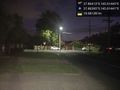
Hash location @-37.8640,145.0144
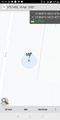
GapS proof
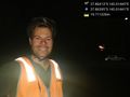
Me at the hash @-37.8640,145.0144
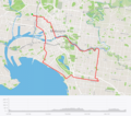
Strava trace


Achievements
Felix Dance earned the Bicycle geohash achievement
|