Difference between revisions of "2020-04-21 51 9"
(new report) |
m (Location correction) |
||
| (3 intermediate revisions by 2 users not shown) | |||
| Line 1: | Line 1: | ||
| − | + | {{meetup graticule | |
| − | |||
| − | |||
| − | |||
| − | |||
| − | |||
| − | |||
| − | |||
| − | |||
| lat=51 | | lat=51 | ||
| lon=9 | | lon=9 | ||
| date=2020-04-21 | | date=2020-04-21 | ||
| − | }} | + | }} |
| + | |||
__NOTOC__ | __NOTOC__ | ||
== Location == | == Location == | ||
| − | + | ||
| + | The hash lay on a meadow at Lippoldsberg. | ||
== Participants == | == Participants == | ||
| − | + | ||
| − | + | [[User:GeorgDerReisende|GeorgDerReisende]] | |
== Plans == | == Plans == | ||
| − | + | ||
| + | Traveling to Lippoldsberg and walking around and to the hash. | ||
== Expedition == | == Expedition == | ||
| − | |||
| − | + | Traveling as usual with tram, regiotram, bus, bus. Then a walk through the village and to the hash. The hash lay on the meadow some meters away from the field way. I gave it a try, because the hash lay on the different maps with different distances from the way. But as I arrived there I found out, that the fence around the meadow was cut down just near the hash. I calculated the distance from the tree 20 steps to the north and 12 steps into the meadow. | |
| − | |||
== Photos == | == Photos == | ||
| − | <!-- | + | |
| − | + | <gallery> | |
| − | -- | + | File:2020-04-21 51 9 GeorgDerReisende 0599.jpg | arrived by bus |
| − | + | File:2020-04-21 51 9 GeorgDerReisende 0743.jpg | the hash area, global view | |
| + | File:2020-04-21 51 9 GeorgDerReisende 0749.jpg | the hash area, zoom | ||
| + | File:2020-04-21 51 9 GeorgDerReisende 0759.jpg | the Neuendorfstraße in Lippoldsberg, the fields on the left and the trees ahead belong to Bodenfelde | ||
| + | File:2020-04-21 51 9 GeorgDerReisende 0760.jpg | a charcoal factory, da rauchen die Schornsteine! | ||
| + | File:2020-04-21 51 9 GeorgDerReisende 0766.jpg | near view to the hash, the meadow is a flood canal | ||
| + | File:2020-04-21 51 9 GeorgDerReisende 0767.jpg | the field way to the hash | ||
| + | File:2020-04-21 51 9 GeorgDerReisende 0768.jpg | no wire at the entrance to the field | ||
| + | File:2020-04-21 51 9 GeorgDerReisende 0769.jpg | calculating from the tree | ||
| + | File:2020-04-21 51 9 GeorgDerReisende 0770.jpg | best choice | ||
| + | File:2020-04-21 51 9 GeorgDerReisende 0771.jpg | view to my daypack | ||
| + | File:2020-04-21 51 9 GeorgDerReisende 0772.jpg | looking to the north | ||
| + | File:2020-04-21 51 9 GeorgDerReisende 0773.jpg | the east | ||
| + | File:2020-04-21 51 9 GeorgDerReisende 0774.jpg | the south | ||
| + | File:2020-04-21 51 9 GeorgDerReisende 0775.jpg | the west | ||
| + | File:2020-04-21 51 9 GeorgDerReisende 0776.jpg | the geohasher | ||
| + | File:2020-04-21 51 9 GeorgDerReisende 0777.jpg | location of hash | ||
</gallery> | </gallery> | ||
| − | |||
| − | |||
| − | |||
| − | + | [[Category:Expeditions]] | |
| − | |||
| − | [[Category: | ||
| − | + | [[Category:Expeditions with photos]] | |
| − | + | [[Category:Expedition without GPS]] | |
| − | |||
| − | [[Category:Expedition | ||
| − | |||
| − | |||
| − | |||
| − | |||
| − | |||
| − | |||
| − | |||
| − | |||
| − | |||
| − | |||
| − | |||
| − | |||
[[Category:Coordinates reached]] | [[Category:Coordinates reached]] | ||
| − | + | {{location|DE|HE|KS}} | |
| − | |||
| − | |||
| − | |||
| − | |||
| − | |||
| − | |||
| − | |||
| − | |||
| − | |||
| − | |||
| − | |||
| − | |||
| − | |||
| − | |||
| − | |||
| − | |||
| − | |||
Latest revision as of 20:41, 16 May 2020
| Tue 21 Apr 2020 in 51,9: 51.6276468, 9.5618938 geohashing.info google osm bing/os kml crox |
Location
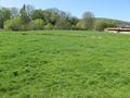
The hash lay on a meadow at Lippoldsberg.
Participants
Plans
Traveling to Lippoldsberg and walking around and to the hash.
Expedition
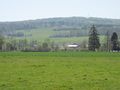
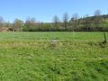
Traveling as usual with tram, regiotram, bus, bus. Then a walk through the village and to the hash. The hash lay on the meadow some meters away from the field way. I gave it a try, because the hash lay on the different maps with different distances from the way. But as I arrived there I found out, that the fence around the meadow was cut down just near the hash. I calculated the distance from the tree 20 steps to the north and 12 steps into the meadow.
Photos
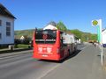
arrived by bus
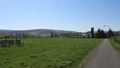
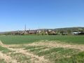
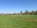
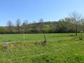
the hash area, global view
the hash area, zoom
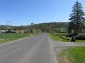
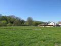
the Neuendorfstraße in Lippoldsberg, the fields on the left and the trees ahead belong to Bodenfelde
a charcoal factory, da rauchen die Schornsteine!
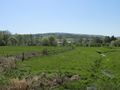
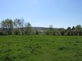
near view to the hash, the meadow is a flood canal
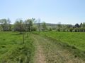
the field way to the hash
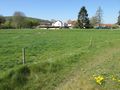
no wire at the entrance to the field
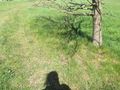
calculating from the tree
best choice
view to my daypack
looking to the north
the east
the south
the west
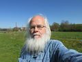
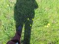
the geohasher
location of hash


