Difference between revisions of "2020-04-24 51 7"
(Tag: Undo) |
|||
| (6 intermediate revisions by 2 users not shown) | |||
| Line 1: | Line 1: | ||
| − | |||
| − | + | {{meetup graticule | |
| − | |||
| − | |||
| − | |||
| − | |||
| − | |||
| − | |||
| lat=51 | | lat=51 | ||
| lon=7 | | lon=7 | ||
| Line 25: | Line 18: | ||
Being happy to have a hash within a reasonable cycling distance I hopped onto my bike at about 1pm and rode off to my first hash. I had stumbled accross geohashing a couple of days ago and was eagerly waiting for one I could reach within an afternoon of cycling on my not very sporty bike. The weather was great: Very sunny and just the right temperature for not getting unpleasently sweaty within minutes. | Being happy to have a hash within a reasonable cycling distance I hopped onto my bike at about 1pm and rode off to my first hash. I had stumbled accross geohashing a couple of days ago and was eagerly waiting for one I could reach within an afternoon of cycling on my not very sporty bike. The weather was great: Very sunny and just the right temperature for not getting unpleasently sweaty within minutes. | ||
| − | Starting in Münster going to the hash and back took me roughly 4h. On my way to the hash I stumbled accross some sort of castle which I didn't plan on, but it's hard to avoid them in this region. It turned out to be "Schloss Senden" and was in a bit of a sorry state. The last part of the way took me along the Dortmund-Ems | + | Starting in Münster going to the hash and back took me roughly 4h. On my way to the hash I stumbled accross some sort of castle which I didn't plan on, but it's hard to avoid them in this region. It turned out to be "Schloss Senden" and was in a bit of a sorry state. It probably deserved it. The last part of the way took me along the Dortmund-Ems canal where I found some boats at a marina and briefly thought about putting on my pirate hat and boarding one for a more convenient way back, but didn't want to catch the Corona-Virus from fighting the current owners. From there it just took a few minutes to get to the hash. |
| − | + | <gallery perrow="6"> | |
| + | Image:2020-04-24_51_7_1_bike-bench.jpg|My bike and a bench. | ||
| + | File:2020-04-24_51_7_1_stream.jpg|A nice stream a travelled along for a bit. | ||
| + | Image:2020-04-24_51_7_2_castle_back.jpg|Schloss Senden. Back looks fine... | ||
| + | Image:2020-04-24_51_7_2_castle_front.jpg|... front... | ||
| + | Image:2020-04-24_51_7_2_castle_bad.jpg|... not so much. | ||
| + | Image:2020-04-24_51_7_3_channel.jpg|Dortmund-Ems canal. | ||
| + | Image:2020-04-24_51_7_3_marina.jpg|A marina. | ||
| + | </gallery> | ||
The hash was on a field. When I arrived two old people were watching the field while taking a break in a small open hut. Not wanting to explain why I was walking onto the field watching my GPS device I waited for them to move on which luckily didn't take too long. | The hash was on a field. When I arrived two old people were watching the field while taking a break in a small open hut. Not wanting to explain why I was walking onto the field watching my GPS device I waited for them to move on which luckily didn't take too long. | ||
| − | Then was able to follow the dividing line between two different fields and the hash turned out to be on some tractor tracks meaning I didn't have to trample down any freshly sowed crops. | + | Then I was able to follow the dividing line between two different fields and the hash turned out to be on some tractor tracks meaning I didn't have to trample down any freshly sowed crops. |
| − | + | <gallery perrow="3"> | |
| + | File:2020-04-24_51_7_4_old_people.jpg|The hut from which they were watching. | ||
| + | File:2020-04-24_51_7_4_cache_far.jpg|The hash turned out to be close to the power pole. | ||
| + | File:2020-04-24_51_7_4_gps.jpg|Reached it. | ||
| + | </gallery> | ||
| − | On my ride back I came accross some suspiciously old buildings | + | |
| − | Just before I reached Münster I sadly had to spot some anti-immigrant propaganda on billboards put up by the locals. I'm conciously not putting up a picture here. Some of them clearly having been destroyed or damaged before I considered | + | On my ride back I again came accross some suspiciously old buildings surrounded by water. Though my castle sense was tingling immediately I approached carefully, but quickly found out they were just as afraid of me as they had apparently destroyed the bridge. There was another bridge, but that one had a large closed gate so I moved on. |
| + | Just before I reached Münster I sadly had to spot some anti-immigrant propaganda on billboards put up by the locals. I'm conciously not putting up a picture here. Some of them clearly having been destroyed or damaged before I considered it being taken care of. | ||
I reached home at roughly 5:15pm. | I reached home at roughly 5:15pm. | ||
| − | + | <gallery perrow="3"> | |
| + | File:2020-04-24_51_7_5_haus_kakesbeck.jpg|Haus Kakesbeck | ||
| + | File:2020-04-24_51_7_5_bridge.jpg|Emergency measures were taken by the inhabitants. | ||
| + | </gallery> | ||
== Achievements == | == Achievements == | ||
{{#vardefine:ribbonwidth|800px}} | {{#vardefine:ribbonwidth|800px}} | ||
| − | |||
| − | |||
| − | |||
| − | |||
| − | + | {{bicycle geohash | |
| + | | latitude = 51 | ||
| + | | longitude = 7 | ||
| + | | date = 2020-04-24 | ||
| + | | name = BroFi | ||
| + | | distance = ~60km | ||
| + | | bothways = true | ||
| + | }} | ||
| + | |||
| + | {{Two to the N achievement | ||
| + | | count = 0 | ||
| + | | latitude = 51 | ||
| + | | longitude = 7 | ||
| + | | date = 2020-04-24 | ||
| + | | name = BroFi | ||
| + | }} | ||
| + | |||
[[Category:Expeditions]] | [[Category:Expeditions]] | ||
| − | |||
[[Category:Expeditions with photos]] | [[Category:Expeditions with photos]] | ||
| − | |||
| − | |||
[[Category:Coordinates reached]] | [[Category:Coordinates reached]] | ||
| + | {{location|DE|NW|COE}} | ||
Latest revision as of 18:27, 30 April 2020
| Fri 24 Apr 2020 in 51,7: 51.7868905, 7.4288914 geohashing.info google osm bing/os kml crox |
Location
In a field north of Lüdinghausen, Northrhine-Westphalia, Germany.
Participants
Expedition
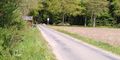
Being happy to have a hash within a reasonable cycling distance I hopped onto my bike at about 1pm and rode off to my first hash. I had stumbled accross geohashing a couple of days ago and was eagerly waiting for one I could reach within an afternoon of cycling on my not very sporty bike. The weather was great: Very sunny and just the right temperature for not getting unpleasently sweaty within minutes.
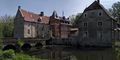
Starting in Münster going to the hash and back took me roughly 4h. On my way to the hash I stumbled accross some sort of castle which I didn't plan on, but it's hard to avoid them in this region. It turned out to be "Schloss Senden" and was in a bit of a sorry state. It probably deserved it. The last part of the way took me along the Dortmund-Ems canal where I found some boats at a marina and briefly thought about putting on my pirate hat and boarding one for a more convenient way back, but didn't want to catch the Corona-Virus from fighting the current owners. From there it just took a few minutes to get to the hash.
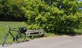
My bike and a bench.
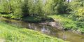
A nice stream a travelled along for a bit.
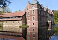
Schloss Senden. Back looks fine...
... front...
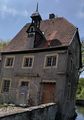
... not so much.
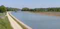
Dortmund-Ems canal.
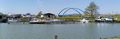
A marina.


The hash was on a field. When I arrived two old people were watching the field while taking a break in a small open hut. Not wanting to explain why I was walking onto the field watching my GPS device I waited for them to move on which luckily didn't take too long. Then I was able to follow the dividing line between two different fields and the hash turned out to be on some tractor tracks meaning I didn't have to trample down any freshly sowed crops.
The hut from which they were watching.
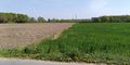
The hash turned out to be close to the power pole.
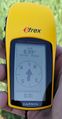
Reached it.


On my ride back I again came accross some suspiciously old buildings surrounded by water. Though my castle sense was tingling immediately I approached carefully, but quickly found out they were just as afraid of me as they had apparently destroyed the bridge. There was another bridge, but that one had a large closed gate so I moved on.
Just before I reached Münster I sadly had to spot some anti-immigrant propaganda on billboards put up by the locals. I'm conciously not putting up a picture here. Some of them clearly having been destroyed or damaged before I considered it being taken care of.
I reached home at roughly 5:15pm.
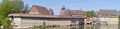
Haus Kakesbeck
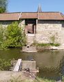
Emergency measures were taken by the inhabitants.

Achievements
BroFi earned the Bicycle geohash achievement
|
