Difference between revisions of "2020-04-30 38 -78"
From Geohashing
([live picture]Made it pic) |
m (Location) |
||
| (5 intermediate revisions by 2 users not shown) | |||
| Line 1: | Line 1: | ||
| − | + | {{meetup graticule | |
| − | |||
| − | |||
| − | |||
| − | |||
| − | |||
| − | |||
| − | |||
| − | |||
| lat=38 | | lat=38 | ||
| lon=-78 | | lon=-78 | ||
| date=2020-04-30 | | date=2020-04-30 | ||
| − | }} | + | }} |
__NOTOC__ | __NOTOC__ | ||
== Location == | == Location == | ||
| − | + | This Geohash is located in a forest near Washington. | |
== Participants == | == Participants == | ||
| − | + | *[[User:OfficeLinebacker|OfficeLinebacker]] | |
| − | |||
| − | |||
| − | |||
| − | |||
== Expedition == | == Expedition == | ||
| − | |||
| − | |||
| − | |||
*I did this one today. However, the app was down while I was there, so I won't be able to provide the info box proof -- [[User:OfficeLinebacker|OfficeLinebacker]] ([[User talk:OfficeLinebacker|talk]]) 23:21, 30 April 2020 (EDT) | *I did this one today. However, the app was down while I was there, so I won't be able to provide the info box proof -- [[User:OfficeLinebacker|OfficeLinebacker]] ([[User talk:OfficeLinebacker|talk]]) 23:21, 30 April 2020 (EDT) | ||
| − | |||
| − | |||
== Photos == | == Photos == | ||
| − | |||
| − | |||
| − | |||
<gallery perrow="5"> | <gallery perrow="5"> | ||
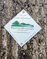
Image:2020-04-30_38_-78_OfficeLinebacker_1588303298668.jpg|Made it pic | Image:2020-04-30_38_-78_OfficeLinebacker_1588303298668.jpg|Made it pic | ||
| + | |||
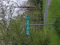
| + | Image:2020-04-30_38_-78_OfficeLinebacker_1588303323059.jpg|This was the land on the other side of the gravel road from the spot. | ||
| + | |||
| + | Image:2020-04-30_38_-78_OfficeLinebacker_1588303378087.jpg|Would it looked out | ||
| + | |||
| + | Image:2020-04-30_38_-78_OfficeLinebacker_1588303397638.jpg|Beautiful view | ||
| + | |||
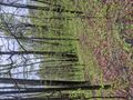
| + | Image:2020-04-30_38_-78_OfficeLinebacker_1588303453367.jpg|The location was presumably the location of a former ski resort, as evidenced by the name and by research I did, however I found no evidence of any area that wasn't completely overgrown. The last season and operation was 1974, so trees grow pretty fast | ||
</gallery> | </gallery> | ||
| Line 44: | Line 32: | ||
<!-- Add any achievement ribbons you earned below, or remove this section --> | <!-- Add any achievement ribbons you earned below, or remove this section --> | ||
| − | |||
| − | |||
| − | |||
| − | |||
| − | |||
| − | |||
| − | |||
| − | |||
| − | |||
| − | |||
| − | |||
| − | |||
| − | |||
| − | |||
[[Category:Expeditions]] | [[Category:Expeditions]] | ||
| − | |||
[[Category:Expeditions with photos]] | [[Category:Expeditions with photos]] | ||
| − | |||
| − | |||
| − | |||
| − | |||
| − | |||
[[Category:Coordinates reached]] | [[Category:Coordinates reached]] | ||
| − | + | {{location|US|VA|RP}} | |
| − | |||
| − | |||
| − | |||
| − | |||
| − | |||
| − | |||
| − | |||
| − | |||
| − | |||
| − | |||
| − | |||
| − | |||
| − | |||
| − | |||
| − | |||
| − | |||
| − | |||
Latest revision as of 19:42, 1 May 2020
| Thu 30 Apr 2020 in 38,-78: 38.7365681, -78.2179574 geohashing.info google osm bing/os kml crox |
Location
This Geohash is located in a forest near Washington.
Participants
Expedition
- I did this one today. However, the app was down while I was there, so I won't be able to provide the info box proof -- OfficeLinebacker (talk) 23:21, 30 April 2020 (EDT)
Photos

Made it pic
This was the land on the other side of the gravel road from the spot.
Would it looked out
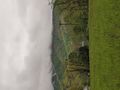
Beautiful view
The location was presumably the location of a former ski resort, as evidenced by the name and by research I did, however I found no evidence of any area that wasn't completely overgrown. The last season and operation was 1974, so trees grow pretty fast


