Difference between revisions of "2020-05-02 62 29"
(Created page with "{{subst:Expedition |lat = 62 |lon = 29 |date = 2020-05-02 }}") |
|||
| (4 intermediate revisions by 2 users not shown) | |||
| Line 1: | Line 1: | ||
| − | + | {{meetup graticule | |
| − | |||
| − | |||
| − | |||
| − | |||
| − | |||
| − | |||
| − | |||
| − | |||
| lat=62 | | lat=62 | ||
| lon=29 | | lon=29 | ||
| date=2020-05-02 | | date=2020-05-02 | ||
| − | }} | + | }} |
__NOTOC__ | __NOTOC__ | ||
== Location == | == Location == | ||
| − | + | In the tiny suburb of Ranta-Mutala in Joensuu, in a residential area but on public land. Also about 600 metres from my home. | |
== Participants == | == Participants == | ||
| − | + | *[[User:Kripakko|Kripakko]] | |
| − | + | *Kripakko's friend | |
== Plans == | == Plans == | ||
| − | + | I planned a short cycling trip with my friend, and I managed to inject this geohash into the plan. It looked on the map like the point would be reachable, and the site was very easy to visit. | |
== Expedition == | == Expedition == | ||
| − | + | Off we went and arrived here easily. Apparently this place is a complex of a few semi-detached houses with small yards. There were a few people hanging about outside, so we chose a route where we would run into as few as possible. A man was working with a bicycle on the nearest backyard, but he pretty much ignored us. | |
| + | |||
| + | I looked at my GPS receiver and realised that the hashpoint was in a bush that was impossible to enter. I did not want to go too near the backyard or the window of the house and attract attention, so I went to the most quiet area by the end wall of the house. I stood behind a fence and got a distance of about four metres. So not quite there yet! | ||
| + | |||
| + | I could have gone between the fence and the bush to get closer, but there was an easier and funnier way: I grabbed a snow pusher and put the GPS receiver in it. Then I reached it out over the bush for a while hoping that I could get significantly closer. I looked at the tracklog on the map and decided that I probably did. Meanwhile my friend took a few pictures for documentation. I put the snow pusher back to its place, and we quickly grabbed our bikes and went on cycling. We ended up cycling 21.1 kilometres in total. | ||
| + | |||
| + | I imported the tracklog in my computer afterwards and calculated the distances to the hashpoint at each time. The shortest recorded distance was 1.8 metres which I deemed to be close enough considering that GPS uncertainty was three metres (no proof, but this is typical for eTrexes at these latitudes when reception is good). | ||
== Tracklog == | == Tracklog == | ||
| − | + | ||
| + | These are the recorded positions of the GPS receiver. Distances below three metres (GPS uncertainty) are marked in red. Footnotes mark the times of the attached pictures. | ||
| + | |||
| + | {| class="wikitable" style="font-size:smaller" | ||
| + | ! style="text-align:left;" | Time | ||
| + | ! style="text-align:left;" | Latitude | ||
| + | ! style="text-align:left;" | Longitude | ||
| + | ! style="text-align:left;" | Distance (m) | ||
| + | |- | ||
| + | |14:28:19||62.613211||29.808654||7.3 | ||
| + | |- | ||
| + | |14:28:24||62.613213||29.808651||7.3 | ||
| + | |- | ||
| + | |14:28:28||62.613208||29.808641||6.6 | ||
| + | |- | ||
| + | |14:28:34||62.613204||29.808645||6.4 | ||
| + | |- | ||
| + | |14:28:38||62.613207||29.808657||7.1 | ||
| + | |- | ||
| + | |14:28:42||62.613209||29.808665||7.6 | ||
| + | |- | ||
| + | |14:28:46||62.613212||29.808678||8.3 | ||
| + | |- | ||
| + | |14:28:50||62.613211||29.808686||8.6 | ||
| + | |- | ||
| + | |14:28:55||62.613211||29.808688||8.6 | ||
| + | |- | ||
| + | |14:29:00||62.613206||29.808624||5.8 | ||
| + | |- | ||
| + | |14:29:05||62.613201||29.808616||5.1 | ||
| + | |- | ||
| + | |14:29:10||62.613200||29.808598||4.5 | ||
| + | |- | ||
| + | |14:29:15||62.613201||29.808595||4.5 | ||
| + | |- | ||
| + | |14:29:20{{ref label|1}}||62.613201||29.808595||4.4 | ||
| + | |- | ||
| + | |14:29:25||62.613208||29.808654||7.1 | ||
| + | |- | ||
| + | |14:29:30||62.613205||29.808634||6.1 | ||
| + | |- | ||
| + | |14:29:35||62.613199||29.808579||3.9 | ||
| + | |- | ||
| + | |14:29:40||62.613193||29.808581||3.3 | ||
| + | |- | ||
| + | |14:29:45||62.613197||29.808566||3.5 | ||
| + | |- | ||
| + | |14:29:50||62.613199||29.808565||3.7 | ||
| + | |- | ||
| + | |14:29:55{{ref label|2}}||62.613192||29.808562||style="color:red"|2.9 | ||
| + | |- | ||
| + | |14:30:00||62.613182||29.808562||style="color:red"|1.8 | ||
| + | |- | ||
| + | |14:30:05||62.613184||29.808575||style="color:red"|2.3 | ||
| + | |- | ||
| + | |14:30:10||62.613188||29.808574||style="color:red"|2.7 | ||
| + | |- | ||
| + | |14:30:15||62.613183||29.808569||style="color:red"|2.1 | ||
| + | |- | ||
| + | |14:30:20{{ref label|3}}||62.613180||29.808568||style="color:red"|1.8 | ||
| + | |- | ||
| + | |14:30:25||62.613194||29.808567||3.2 | ||
| + | |- | ||
| + | |14:30:30||62.613195||29.808567||3.3 | ||
| + | |- | ||
| + | |14:30:35||62.613190||29.808594||3.4 | ||
| + | |- | ||
| + | |14:30:40||62.613186||29.808596||3.2 | ||
| + | |- | ||
| + | |14:30:45||62.613182||29.808623||4.1 | ||
| + | |- | ||
| + | |14:30:50||62.613211||29.808659||7.5 | ||
| + | |- | ||
| + | |14:30:55||62.613204||29.808647||6.5 | ||
| + | |- | ||
| + | |14:31:00||62.613198||29.808639||5.7 | ||
| + | |- | ||
| + | |14:31:05||62.613191||29.808631||5.0 | ||
| + | |- | ||
| + | |14:31:10||62.613182||29.808643||5.0 | ||
| + | |- | ||
| + | |14:31:15||62.613181||29.808628||4.3 | ||
| + | |- | ||
| + | |14:31:20||62.613179||29.808631||4.4 | ||
| + | |- | ||
| + | |14:31:25||62.613178||29.808641||4.8 | ||
| + | |- | ||
| + | |14:31:30||62.613179||29.808648||5.2 | ||
| + | |- | ||
| + | |14:31:35||62.613177||29.808642||4.9 | ||
| + | |} | ||
| + | |||
| + | {{note label|1|First picture.}} | ||
| + | {{note label|2|Second picture.}} | ||
| + | {{note label|3|Third picture.}} | ||
== Photos == | == Photos == | ||
| − | < | + | <gallery perrow="3"> |
| − | + | 2020-05-02_62_29_01.jpg | Standing as close as I could without drawing attention... four metres to go. | |
| − | -- | + | 2020-05-02_62_29_02.jpg | GPS receiver on the snow pusher. |
| − | + | 2020-05-02_62_29_03.jpg | GPS receiver being reached out closer to the actual hashpoint. | |
</gallery> | </gallery> | ||
== Achievements == | == Achievements == | ||
{{#vardefine:ribbonwidth|800px}} | {{#vardefine:ribbonwidth|800px}} | ||
| − | + | {{Proxy Geohash | latitude = 62| longitude = 29| date = 2020-05-02 | device = snow pusher | name = Kripakko}} | |
| + | {{bicycle geohash | latitude = 62 | longitude = 29 | date = 2020-05-02 | name = Kripakko | distance = 21.1 km | bothways = true }} | ||
| + | {{drag-along | latitude = 62 | longitude = 29 | date = 2020-05-02 | partner = his friend | name = Kripakko }} | ||
| + | {{couch potato geohash | latitude = 62 | longitude = 29 | date = 2020-05-02 | name = Kripakko | honor = true }} | ||
| − | |||
| − | |||
| − | |||
| − | |||
| − | |||
| − | |||
| − | |||
| − | |||
| − | |||
| − | |||
| − | |||
| − | |||
| − | |||
| − | |||
[[Category:Expeditions]] | [[Category:Expeditions]] | ||
| − | |||
[[Category:Expeditions with photos]] | [[Category:Expeditions with photos]] | ||
| − | |||
| − | |||
| − | |||
| − | |||
| − | |||
[[Category:Coordinates reached]] | [[Category:Coordinates reached]] | ||
| − | + | {{location|FI|13}} | |
| − | |||
| − | |||
| − | |||
| − | |||
| − | |||
| − | |||
| − | |||
| − | |||
| − | |||
| − | |||
| − | |||
| − | |||
| − | |||
| − | |||
| − | |||
| − | |||
| − | |||
Latest revision as of 15:28, 8 May 2020
| Sat 2 May 2020 in 62,29: 62.6131665, 29.8085498 geohashing.info google osm bing/os kml crox |
Location
In the tiny suburb of Ranta-Mutala in Joensuu, in a residential area but on public land. Also about 600 metres from my home.
Participants
- Kripakko
- Kripakko's friend
Plans
I planned a short cycling trip with my friend, and I managed to inject this geohash into the plan. It looked on the map like the point would be reachable, and the site was very easy to visit.
Expedition
Off we went and arrived here easily. Apparently this place is a complex of a few semi-detached houses with small yards. There were a few people hanging about outside, so we chose a route where we would run into as few as possible. A man was working with a bicycle on the nearest backyard, but he pretty much ignored us.
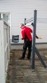
I looked at my GPS receiver and realised that the hashpoint was in a bush that was impossible to enter. I did not want to go too near the backyard or the window of the house and attract attention, so I went to the most quiet area by the end wall of the house. I stood behind a fence and got a distance of about four metres. So not quite there yet!
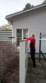
I could have gone between the fence and the bush to get closer, but there was an easier and funnier way: I grabbed a snow pusher and put the GPS receiver in it. Then I reached it out over the bush for a while hoping that I could get significantly closer. I looked at the tracklog on the map and decided that I probably did. Meanwhile my friend took a few pictures for documentation. I put the snow pusher back to its place, and we quickly grabbed our bikes and went on cycling. We ended up cycling 21.1 kilometres in total.
I imported the tracklog in my computer afterwards and calculated the distances to the hashpoint at each time. The shortest recorded distance was 1.8 metres which I deemed to be close enough considering that GPS uncertainty was three metres (no proof, but this is typical for eTrexes at these latitudes when reception is good).
Tracklog
These are the recorded positions of the GPS receiver. Distances below three metres (GPS uncertainty) are marked in red. Footnotes mark the times of the attached pictures.
| Time | Latitude | Longitude | Distance (m) |
|---|---|---|---|
| 14:28:19 | 62.613211 | 29.808654 | 7.3 |
| 14:28:24 | 62.613213 | 29.808651 | 7.3 |
| 14:28:28 | 62.613208 | 29.808641 | 6.6 |
| 14:28:34 | 62.613204 | 29.808645 | 6.4 |
| 14:28:38 | 62.613207 | 29.808657 | 7.1 |
| 14:28:42 | 62.613209 | 29.808665 | 7.6 |
| 14:28:46 | 62.613212 | 29.808678 | 8.3 |
| 14:28:50 | 62.613211 | 29.808686 | 8.6 |
| 14:28:55 | 62.613211 | 29.808688 | 8.6 |
| 14:29:00 | 62.613206 | 29.808624 | 5.8 |
| 14:29:05 | 62.613201 | 29.808616 | 5.1 |
| 14:29:10 | 62.613200 | 29.808598 | 4.5 |
| 14:29:15 | 62.613201 | 29.808595 | 4.5 |
| 14:29:20[1] | 62.613201 | 29.808595 | 4.4 |
| 14:29:25 | 62.613208 | 29.808654 | 7.1 |
| 14:29:30 | 62.613205 | 29.808634 | 6.1 |
| 14:29:35 | 62.613199 | 29.808579 | 3.9 |
| 14:29:40 | 62.613193 | 29.808581 | 3.3 |
| 14:29:45 | 62.613197 | 29.808566 | 3.5 |
| 14:29:50 | 62.613199 | 29.808565 | 3.7 |
| 14:29:55[2] | 62.613192 | 29.808562 | 2.9 |
| 14:30:00 | 62.613182 | 29.808562 | 1.8 |
| 14:30:05 | 62.613184 | 29.808575 | 2.3 |
| 14:30:10 | 62.613188 | 29.808574 | 2.7 |
| 14:30:15 | 62.613183 | 29.808569 | 2.1 |
| 14:30:20[3] | 62.613180 | 29.808568 | 1.8 |
| 14:30:25 | 62.613194 | 29.808567 | 3.2 |
| 14:30:30 | 62.613195 | 29.808567 | 3.3 |
| 14:30:35 | 62.613190 | 29.808594 | 3.4 |
| 14:30:40 | 62.613186 | 29.808596 | 3.2 |
| 14:30:45 | 62.613182 | 29.808623 | 4.1 |
| 14:30:50 | 62.613211 | 29.808659 | 7.5 |
| 14:30:55 | 62.613204 | 29.808647 | 6.5 |
| 14:31:00 | 62.613198 | 29.808639 | 5.7 |
| 14:31:05 | 62.613191 | 29.808631 | 5.0 |
| 14:31:10 | 62.613182 | 29.808643 | 5.0 |
| 14:31:15 | 62.613181 | 29.808628 | 4.3 |
| 14:31:20 | 62.613179 | 29.808631 | 4.4 |
| 14:31:25 | 62.613178 | 29.808641 | 4.8 |
| 14:31:30 | 62.613179 | 29.808648 | 5.2 |
| 14:31:35 | 62.613177 | 29.808642 | 4.9 |
Photos

Standing as close as I could without drawing attention... four metres to go.
GPS receiver on the snow pusher.
GPS receiver being reached out closer to the actual hashpoint.


Achievements
Kripakko earned the Geohash by proxy achievement
|
Kripakko earned the Bicycle geohash achievement
|
Kripakko earned the Drag-along achievement
|
