Difference between revisions of "2020-05-10 -37 144"
Felix Dance (talk | contribs) (An expedition message sent via Geohash Droid for Android.) |
m (More specific location) |
||
| (12 intermediate revisions by 3 users not shown) | |||
| Line 1: | Line 1: | ||
| − | + | [[Image:{{{image|Geohash 2020-05-10 -37 144 Ruth and Felix.jpg}}}|thumb|left]] | |
| − | + | {{meetup graticule | |
| − | |||
| − | |||
| − | |||
| − | |||
| − | |||
| − | |||
| lat=-37 | | lat=-37 | ||
| lon=144 | | lon=144 | ||
| date=2020-05-10 | | date=2020-05-10 | ||
| − | }} | + | }} |
__NOTOC__ | __NOTOC__ | ||
| + | |||
== Location == | == Location == | ||
| − | + | On a sloped road verge in Keilor. | |
== Participants == | == Participants == | ||
| − | + | *[[User:Felix Dance|Felix Dance]] | |
| − | + | *Ruth | |
| − | == | + | == Expedition == |
| − | + | Ruth and I had been hoping to go on a bit of a ride this weekend and in my mind the Maribyrnong trail up to Brimbank Park was a good candidate. So it was fortuitous that today's geohash was close to this very route, just beyond the termination of the trail. | |
| − | + | We set off after lunch, just as the sunny morning gave way to a windy, overcast afternoon. We frustratingly negotiated the bustling foot-traffic of the Maribyrnong trail - everyone being out and about because the gyms are closed and there's nowhere practical to go. | |
| − | + | ||
| + | After climbing a few hills and winding our way along the circuitous river we reached the end of the sealed road and proceeded on gravel. My Surly Troll, with its 2.5 inches of knobbly tyres, was fine with the terrain but Ruth's Liv Thrive road basher was a little less certain on this surface. | ||
| + | |||
| + | The river provided distraction, however, displaying reedy rapids, slumping river red gums and towering truss bridges. Soon we arrived at Brimbank Park and we worked our way across a weir into the suburbs of Keilor. | ||
| + | |||
| + | A few awkward road crossings just as it started raining deposited us at the road nearest the hash. We dumped our bikes in the grass and clambered up the steep hillside of the road verge to reach a dilapidated track upon the side of which the hash was situated. We took photos, congratulated ourselves on mission success and returned to our bikes. | ||
| + | |||
| + | We celebrated this hash-triumph with a stop-off at the Keilor shops to buy medium chips and gravy (pictured below). This gave us the energy to navigate our way home through the Keilor cemetery, over an almost comically long, splindly freeway pedestrian bridge, past an urban-renewed quarry and down the Steele Creek bike path - a part Melbourne's cycling infrastructure I had yet to explore - battling clouds of insects invisibly hovering at face-height. | ||
| + | |||
| + | At the point of retracing our Maribyrnong River steps we veered off to take the roads home, mainly along the Craigieburn rail line. Coincidentally, Ruth saw some friends outside a house in Moonee Ponds as we rode by. | ||
| − | + | The final stretch home through Ascot Vale was a display of autumness - saturated coloured leaves backdropped by a gloomy sky. It rained shortly after we got back inside where we were reunited with our cats. | |
| − | |||
== Photos == | == Photos == | ||
| − | |||
| − | |||
| − | |||
<gallery perrow="5"> | <gallery perrow="5"> | ||
| + | Image:2020-05-10_-37_144_Felix Dance_1589104721799.jpg|Geohash success! | ||
| + | File:Geohash 2020-05-10 -37 144 Bikes.jpg|Parked bikes | ||
| + | File:Geohash 2020-05-10 -37 144 Ruth and Felix.jpg|Ruth and Felix at the hash | ||
| + | File:Geohash 2020-05-10 -37 144 Track.jpg|Track to the hash | ||
| + | File:Geohash 2020-05-10 -37 144 Verge.jpg|Road verge veg | ||
| + | File:Geohash 2020-05-10 -37 144 Chips.jpg|Post-hash chips and gravy | ||
| + | File:Geohash 2020-05-10 -37 144 Route.jpg|Strava route | ||
</gallery> | </gallery> | ||
== Achievements == | == Achievements == | ||
| − | {{ | + | {{bicycle geohash |
| − | |||
| − | |||
| − | |||
| − | |||
| − | |||
| − | |||
| − | |||
| − | |||
| − | |||
| − | |||
| − | |||
| − | |||
| − | + | | latitude = -37 | |
| + | | longitude = 144 | ||
| + | | date = 2020-05-10 | ||
| + | | name = Felix and Ruth | ||
| + | | distance = 44.4 kms | ||
| + | | bothways = true | ||
| + | | image = Geohash 2020-05-10 -37 144 Ruth and Felix.jpg | ||
| + | }} | ||
| − | |||
[[Category:Expeditions]] | [[Category:Expeditions]] | ||
| − | |||
[[Category:Expeditions with photos]] | [[Category:Expeditions with photos]] | ||
| − | |||
| − | |||
| − | |||
| − | |||
| − | |||
[[Category:Coordinates reached]] | [[Category:Coordinates reached]] | ||
| − | + | {{location|AU|VIC|BR}} | |
| − | |||
| − | |||
| − | |||
| − | |||
| − | |||
| − | |||
| − | |||
| − | |||
| − | |||
| − | |||
| − | |||
| − | |||
| − | |||
| − | |||
| − | |||
| − | |||
| − | |||
Latest revision as of 12:59, 1 August 2020

| Sun 10 May 2020 in -37,144: -37.7133386, 144.8297909 geohashing.info google osm bing/os kml crox |
Location
On a sloped road verge in Keilor.
Participants
- Felix Dance
- Ruth
Expedition
Ruth and I had been hoping to go on a bit of a ride this weekend and in my mind the Maribyrnong trail up to Brimbank Park was a good candidate. So it was fortuitous that today's geohash was close to this very route, just beyond the termination of the trail.
We set off after lunch, just as the sunny morning gave way to a windy, overcast afternoon. We frustratingly negotiated the bustling foot-traffic of the Maribyrnong trail - everyone being out and about because the gyms are closed and there's nowhere practical to go.
After climbing a few hills and winding our way along the circuitous river we reached the end of the sealed road and proceeded on gravel. My Surly Troll, with its 2.5 inches of knobbly tyres, was fine with the terrain but Ruth's Liv Thrive road basher was a little less certain on this surface.
The river provided distraction, however, displaying reedy rapids, slumping river red gums and towering truss bridges. Soon we arrived at Brimbank Park and we worked our way across a weir into the suburbs of Keilor.
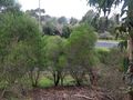
A few awkward road crossings just as it started raining deposited us at the road nearest the hash. We dumped our bikes in the grass and clambered up the steep hillside of the road verge to reach a dilapidated track upon the side of which the hash was situated. We took photos, congratulated ourselves on mission success and returned to our bikes.
We celebrated this hash-triumph with a stop-off at the Keilor shops to buy medium chips and gravy (pictured below). This gave us the energy to navigate our way home through the Keilor cemetery, over an almost comically long, splindly freeway pedestrian bridge, past an urban-renewed quarry and down the Steele Creek bike path - a part Melbourne's cycling infrastructure I had yet to explore - battling clouds of insects invisibly hovering at face-height.
At the point of retracing our Maribyrnong River steps we veered off to take the roads home, mainly along the Craigieburn rail line. Coincidentally, Ruth saw some friends outside a house in Moonee Ponds as we rode by.
The final stretch home through Ascot Vale was a display of autumness - saturated coloured leaves backdropped by a gloomy sky. It rained shortly after we got back inside where we were reunited with our cats.
Photos
Geohash success!
Parked bikes
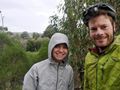
Ruth and Felix at the hash
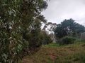
Track to the hash
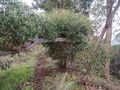
Road verge veg

Post-hash chips and gravy
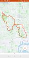
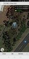
Strava route


Achievements
Felix and Ruth earned the Bicycle geohash achievement
|