Difference between revisions of "2020-05-16 47 -122"
Coyotebush (talk | contribs) ([live] Heading out.) |
(success here - will Coyotebush spot the mark?) |
||
| Line 21: | Line 21: | ||
== Expedition == | == Expedition == | ||
| − | + | Did other things - hey, it's Saturday - and also got rained on a bit. Looked up at 10 to 4 and said "Hey, time for Geohashing!" | |
| + | This is a short drive from my house, mostly downhill: | ||
*Running a few minutes late, but it's all downhill from here! -- [[User:Thomcat|Thomcat]] ([[User talk:Thomcat|talk]]) [https://openstreetmap.org/?lat=47.69063930&lon=-122.38947620&zoom=16&layers=B000FTF @47.6906,-122.3895] 16:03, 16 May 2020 (PDT) | *Running a few minutes late, but it's all downhill from here! -- [[User:Thomcat|Thomcat]] ([[User talk:Thomcat|talk]]) [https://openstreetmap.org/?lat=47.69063930&lon=-122.38947620&zoom=16&layers=B000FTF @47.6906,-122.3895] 16:03, 16 May 2020 (PDT) | ||
| + | |||
| + | I only saw one entrance into the parking lot that wasn't coned off - but plenty of street parking right next to the spot. I parked on the street, grabbed pink chalk (a darker color might have been better), and paced the spot. Not sure if the giant metal doors threw off the GPS, but it did settle at less than a meter at one point - and the location matches the aerial google maps view. | ||
| + | |||
| + | Chalked, selfy, and took a few other pictures of the area - then off to stand in line to get into Trader Joe's. Saturday success! | ||
*Heading out. -- [[User:Coyotebush|Coyotebush]] ([[User talk:Coyotebush|talk]]) 17:45, 16 May 2020 (PDT) | *Heading out. -- [[User:Coyotebush|Coyotebush]] ([[User talk:Coyotebush|talk]]) 17:45, 16 May 2020 (PDT) | ||
| Line 49: | Line 54: | ||
== Achievements == | == Achievements == | ||
{{#vardefine:ribbonwidth|800px}} | {{#vardefine:ribbonwidth|800px}} | ||
| − | |||
| − | |||
| − | |||
| − | |||
| − | |||
| − | |||
| − | |||
| − | |||
| − | |||
| − | |||
| − | |||
| − | |||
| − | |||
| − | |||
[[Category:Expeditions]] | [[Category:Expeditions]] | ||
[[Category:Expeditions with photos]] | [[Category:Expeditions with photos]] | ||
[[Category:Coordinates reached]] | [[Category:Coordinates reached]] | ||
| − | |||
| − | |||
| − | |||
| − | |||
| − | |||
| − | |||
| − | |||
| − | |||
| − | |||
| − | |||
| − | |||
{{location|US|WA|KI}} | {{location|US|WA|KI}} | ||
Revision as of 01:40, 17 May 2020
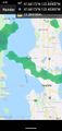
| Sat 16 May 2020 in Seattle: 47.6817281, -122.4040167 geohashing.info google osm bing/os kml crox |
Location
Public parking area at Shilshole Bay Marina.
Participants
Plans
High chance of rain, but plan to be there at 4:00.
- I might wait until later - looks like there may be a break in the rain between roughly 5 and 7. Will look for your chalk mark :) Coyotebush (talk) 21:05, 16 May 2020 (UTC)
Expedition
Did other things - hey, it's Saturday - and also got rained on a bit. Looked up at 10 to 4 and said "Hey, time for Geohashing!"
This is a short drive from my house, mostly downhill:
- Running a few minutes late, but it's all downhill from here! -- Thomcat (talk) @47.6906,-122.3895 16:03, 16 May 2020 (PDT)
I only saw one entrance into the parking lot that wasn't coned off - but plenty of street parking right next to the spot. I parked on the street, grabbed pink chalk (a darker color might have been better), and paced the spot. Not sure if the giant metal doors threw off the GPS, but it did settle at less than a meter at one point - and the location matches the aerial google maps view.
Chalked, selfy, and took a few other pictures of the area - then off to stand in line to get into Trader Joe's. Saturday success!
- Heading out. -- Coyotebush (talk) 17:45, 16 May 2020 (PDT)
Tracklog
Photos

geohasher @47.6817,-122.4040
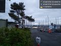
Shilshole marins @47.6817,-122.4042
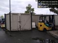
storage structures @47.6817,-122.4040
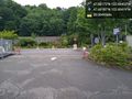
Controlled access @47.6819,-122.4042
Just managed to escape the rain @47.6817,-122.4039


