Difference between revisions of "2020-06-06 50 8"
From Geohashing
(new report) |
m (Location) |
||
| (One intermediate revision by one other user not shown) | |||
| Line 1: | Line 1: | ||
| − | + | {{meetup graticule | |
| − | |||
| − | |||
| − | |||
| − | |||
| − | |||
| − | |||
| − | |||
| − | |||
| lat={{#explode:{{SUBPAGENAME}}| |1}} | | lat={{#explode:{{SUBPAGENAME}}| |1}} | ||
| lon={{#explode:{{SUBPAGENAME}}| |2}} | | lon={{#explode:{{SUBPAGENAME}}| |2}} | ||
| date={{#explode:{{SUBPAGENAME}}| |0}} | | date={{#explode:{{SUBPAGENAME}}| |0}} | ||
| − | }} | + | }} |
| + | |||
__NOTOC__ | __NOTOC__ | ||
== Location == | == Location == | ||
| − | + | ||
| + | The hash lay in a sideway lane of Kieferweg in Neu-Isenburg. | ||
== Participants == | == Participants == | ||
| − | + | ||
| − | + | [[User:GeorgDerReisende|GeorgDerReisende]] | |
== Plans == | == Plans == | ||
| − | + | ||
| + | A journey to Neu-Isenburg and a walk through the city. Wanted to be there at hash o'clock. | ||
== Expedition == | == Expedition == | ||
| − | |||
| − | + | I arrived in Neu-Isenburg in time. Walked through the city. And suddenly - hunger! I bought a handfull of pommes. Ate them. Walked on. And suddenly it was hash o'clock, and I was 350 away. And as I arrived there, I was six minutes late! | |
| − | |||
== Photos == | == Photos == | ||
| − | < | + | |
| − | + | <gallery> | |
| − | -- | + | File:2020-06-06 50 8 GeorgDerReisende 5856.jpg | arrived, in time |
| − | + | File:2020-06-06 50 8 GeorgDerReisende 5993.jpg | hash o'clock, but 350 meters away | |
| + | File:2020-06-06 50 8 GeorgDerReisende 5998.jpg | the sideway lane | ||
| + | File:2020-06-06 50 8 GeorgDerReisende 5999.jpg | the hash is 3.8 meters at right of the hedge | ||
| + | File:2020-06-06 50 8 GeorgDerReisende 6000.jpg | me there, but six minutes late | ||
</gallery> | </gallery> | ||
| Line 40: | Line 36: | ||
<!-- Add any achievement ribbons you earned below, or remove this section --> | <!-- Add any achievement ribbons you earned below, or remove this section --> | ||
| − | + | None, ooh. | |
| − | |||
| − | |||
| − | + | [[Category:Expeditions]] | |
| − | + | [[Category:Expeditions with photos]] | |
| − | |||
| − | [[Category: | ||
| − | |||
| − | + | [[Category:Expedition without GPS]] | |
| − | |||
| − | |||
| − | |||
| − | |||
| − | |||
| − | |||
| − | |||
| − | |||
| − | |||
[[Category:Coordinates reached]] | [[Category:Coordinates reached]] | ||
| − | + | {{location|DE|HE|OF}} | |
| − | |||
| − | |||
| − | |||
| − | |||
| − | |||
| − | |||
| − | |||
| − | |||
| − | |||
| − | |||
| − | |||
| − | |||
| − | |||
| − | |||
| − | |||
| − | |||
| − | |||
Latest revision as of 10:42, 8 June 2020
| Sat 6 Jun 2020 in 50,8: 50.0419576, 8.6998630 geohashing.info google osm bing/os kml crox |
Location
The hash lay in a sideway lane of Kieferweg in Neu-Isenburg.
Participants
Plans
A journey to Neu-Isenburg and a walk through the city. Wanted to be there at hash o'clock.
Expedition
I arrived in Neu-Isenburg in time. Walked through the city. And suddenly - hunger! I bought a handfull of pommes. Ate them. Walked on. And suddenly it was hash o'clock, and I was 350 away. And as I arrived there, I was six minutes late!
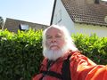
Photos
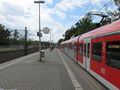
arrived, in time
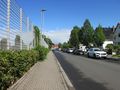
hash o'clock, but 350 meters away
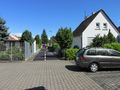
the sideway lane
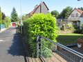
the hash is 3.8 meters at right of the hedge
me there, but six minutes late


Achievements
None, ooh.