Difference between revisions of "2020-06-17 61 29"
m (Location) |
|||
| Line 32: | Line 32: | ||
[[Category:Expeditions with photos]] | [[Category:Expeditions with photos]] | ||
[[Category:Coordinates reached]] | [[Category:Coordinates reached]] | ||
| + | {{location|FI|13}} | ||
Latest revision as of 19:42, 17 June 2020
| Wed 17 Jun 2020 in 61,29: 61.8078467, 29.7284761 geohashing.info google osm bing/os kml crox |
Location
In a young pine forest just 60 metres off highway 6.
The point on a topographic map: [1]
Participants
Expedition
This hashpoint was exceptionally lucky since it was located very close to a road along which I would travel today. I visited South Karelia with my family, and on the way back I got the driver to stop the car so I could go and quickly find the hashpoint. The forest was young and dense but passable without too much pathfinding effort. I just took a few photos to document the visit and returned to the car, where I arrived five minutes after I had left.
Photos
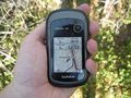
Hashpoint reached!
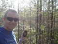
Selfie at the hashpoint.
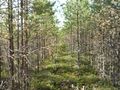
The hashpoint was located at the end of this opening.
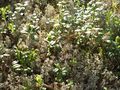
Blossoming lingonberry (Vaccinium vitis-idaea) with grey reindeer lichen (Cladonia rangiferina).
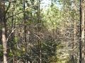
How the way to the hashpoint looked like. Somewhat difficult to walk through.


Achievements
Kripakko earned the Land geohash achievement
|