Difference between revisions of "2020-06-20 -37 144"
([live picture]Friend convinced us to do this one since we live close by. My first ever geohash!) |
m (More specific location) |
||
| (13 intermediate revisions by 5 users not shown) | |||
| Line 1: | Line 1: | ||
| − | + | [[Image:{{{image|2020-06-20_-37_144_Cattaby_1592645235020.jpg}}}|thumb|left]] | |
| − | + | {{meetup graticule | |
| − | |||
| − | |||
| − | |||
| − | |||
| − | |||
| − | |||
| lat=-37 | | lat=-37 | ||
| lon=144 | | lon=144 | ||
| date=2020-06-20 | | date=2020-06-20 | ||
| − | }} | + | }} |
__NOTOC__ | __NOTOC__ | ||
== Location == | == Location == | ||
| − | + | Steep hill in Pascoe Vale | |
== Participants == | == Participants == | ||
| − | + | Expedition 1: | |
| − | + | *[[User:Cattaby|Cat]] | |
| + | *Mitch | ||
| − | + | Expedition 2: | |
| − | + | *[[User:Lachie|Lachie]] | |
| + | *[[User:Stevage|Stevage]] | ||
| − | + | Expedition 3: | |
| − | + | *[[User:Felix Dance|Felix Dance]] | |
| − | == | + | == Expeditions == |
| − | + | === Cat === | |
| + | Friend convinced us to do this one since we live close by. Didn't even have to put proper outdoor clothes on. Overall a win. | ||
| − | |||
| − | |||
| − | |||
| − | |||
<gallery perrow="5"> | <gallery perrow="5"> | ||
| + | Image:2020-06-20_-37_144_Cattaby_1592645235020.jpg|Selfie of first ever geohash | ||
| + | </gallery> | ||
| + | |||
| + | === Stevage === | ||
| + | [[User:Stevage|Steve]] and Lachie rode over around 10pm. We knew Felix was on his way, so we messaged him to say we'd already gone home, but hung around drinking beer. As you do. | ||
| + | |||
| + | === Felix Dance === | ||
| + | I didn't notice this geohash until late in the day, while I was over at a friends' place in Richmond brewing beer. I immediately alerted Cat and Mitch since it was so convenient to their place. As I see above they got there. | ||
| + | |||
| + | I also messaged Lachie and he and Stevage made a separate attempt. | ||
| + | |||
| + | After I'd returned from Richmond I changed bikes and headed out towards the hash at about 10:30pm. Sadly, Lachie messaged me to say he and Stevage had already returned from the hash so I'd have to do it on my own. Ah well. | ||
| + | |||
| + | But no! When I arrived I was surprised to see Steve and Lachie still at the hash, sitting under a tree on the side of the road drinking beer. They'd lied to me! | ||
| + | |||
| + | We hung out for a little while, I drank some port with the others, took photos at the hash and we all rode home together via the Moonee Ponds Creek bike path, through the fog. | ||
| + | |||
| + | [https://goo.gl/maps/pn5m7eBQkYC78hxVA Here] is the route I took. | ||
| − | + | <gallery> | |
| + | File:Geohash 2020-06-20 -37 144 01 Hash buddies.jpg|Geohash buddies! | ||
| + | File:Geohash 2020-06-20 -37 144 02 GPS.jpg|GPS Proof | ||
| + | File:Geohash 2020-06-20 -37 144 04 Hill.jpg|Downhill | ||
| + | File:Geohash 2020-06-20 -37 144 03 Fog.jpg|Fog on the return | ||
</gallery> | </gallery> | ||
== Achievements == | == Achievements == | ||
{{#vardefine:ribbonwidth|800px}} | {{#vardefine:ribbonwidth|800px}} | ||
| − | |||
| − | + | {{bicycle geohash | |
| − | |||
| − | |||
| − | + | | latitude = -37 | |
| + | | longitude = 144 | ||
| + | | date = 2020-06-20 | ||
| + | | name = Felix Dance, Stevage and Lachie | ||
| + | | distance = 22 kms | ||
| + | | bothways = true | ||
| + | | image = Geohash 2020-06-20 -37 144 03 Fog.jpg | ||
| + | }} | ||
| − | + | {{Walk geohash | |
| − | |||
| − | |||
| − | |||
| − | + | | latitude = -37 | |
| + | | longitude = 144 | ||
| + | | date = 2020-06-20 | ||
| + | | name = Cat and Mitch | ||
| + | | distance = 1.3 kms | ||
| + | | image = 2020-06-20_-37_144_Cattaby_1592645235020.jpg | ||
| + | }} | ||
| − | + | {{drag-along | |
| − | |||
| − | |||
| − | |||
| − | |||
| − | |||
| − | |||
| − | |||
| − | |||
| − | |||
| + | | latitude = -37 | ||
| + | | longitude = 144 | ||
| + | | date = 2020-06-20 | ||
| + | | partner = Cattaby | ||
| + | | name = Mitch, via Felix Dance | ||
| + | | image = | ||
| + | }} | ||
| − | + | {{consecutive geohash | |
| − | |||
| − | |||
| − | |||
| − | |||
| − | |||
| − | |||
| − | |||
| − | + | | count = 3 | |
| − | + | | latitude = -37 | |
| − | + | | longitude = 144 | |
| − | + | | date = 2020-06-20 | |
| − | [[ | + | | name = [[User:Felix Dance|Felix Dance]] |
| + | }} | ||
| − | + | [[Category:Expeditions]] | |
| + | [[Category:Expeditions with photos]] | ||
| + | [[Category:Coordinates reached]] | ||
| + | {{location|AU|VIC|MD}} | ||
Latest revision as of 13:00, 1 August 2020

| Sat 20 Jun 2020 in -37,144: -37.7319364, 144.9322605 geohashing.info google osm bing/os kml crox |
Location
Steep hill in Pascoe Vale
Participants
Expedition 1:
- Cat
- Mitch
Expedition 2:
Expedition 3:
Expeditions
Cat
Friend convinced us to do this one since we live close by. Didn't even have to put proper outdoor clothes on. Overall a win.

Selfie of first ever geohash
Stevage
Steve and Lachie rode over around 10pm. We knew Felix was on his way, so we messaged him to say we'd already gone home, but hung around drinking beer. As you do.
Felix Dance
I didn't notice this geohash until late in the day, while I was over at a friends' place in Richmond brewing beer. I immediately alerted Cat and Mitch since it was so convenient to their place. As I see above they got there.
I also messaged Lachie and he and Stevage made a separate attempt.
After I'd returned from Richmond I changed bikes and headed out towards the hash at about 10:30pm. Sadly, Lachie messaged me to say he and Stevage had already returned from the hash so I'd have to do it on my own. Ah well.
But no! When I arrived I was surprised to see Steve and Lachie still at the hash, sitting under a tree on the side of the road drinking beer. They'd lied to me!
We hung out for a little while, I drank some port with the others, took photos at the hash and we all rode home together via the Moonee Ponds Creek bike path, through the fog.
Here is the route I took.
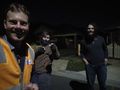
Geohash buddies!

GPS Proof
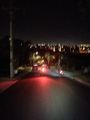
Downhill
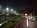
Fog on the return


Achievements
Felix Dance, Stevage and Lachie earned the Bicycle geohash achievement
|
Cat and Mitch earned the Walk geohash Achievement
|
Mitch, via Felix Dance earned the Drag-along achievement
|
Felix Dance earned the Consecutive geohash achievement
|