Difference between revisions of "2020-07-04 48 -117"
From Geohashing
([live picture]ggeohasher [https://openstreetmap.org/?lat=48.01841160&lon=-117.50715560&zoom=16&layers=B000FTF @48.0184,-117.5072]) |
|||
| Line 1: | Line 1: | ||
| − | + | {{meetup graticule | |
| − | |||
| − | |||
| − | |||
| − | |||
| − | |||
| − | |||
| − | |||
| − | |||
| lat=48 | | lat=48 | ||
| lon=-117 | | lon=-117 | ||
| date=2020-07-04 | | date=2020-07-04 | ||
| − | }} | + | | graticule_name=Colville |
| + | | graticule_link=Colville,_Washington | ||
| + | }} | ||
__NOTOC__ | __NOTOC__ | ||
== Location == | == Location == | ||
| − | + | A farmer's field just north of Deer Park | |
== Participants == | == Participants == | ||
| − | + | * [[User:Thomcat|Thomcat]] | |
| − | |||
== Plans == | == Plans == | ||
| − | + | Visit early in the morning then head west to Grand Coulee for a [[2020-07-04 48 -119|multihash]]. | |
== Expedition == | == Expedition == | ||
| − | + | Getting out of COVID Spokane, I spent the night hearing the booms of July 3rd firecrackers. The road leading to the proper field was easy to find and drive, and I found myself at the right spot at 4:30 am. | |
| + | |||
| + | The actual point was in the middle of the field, over 100m away. Per good ambassadorship, I refused to trample the farmer's nice young crops and settled for a photo on the edge of the field. | ||
== Tracklog == | == Tracklog == | ||
| Line 44: | Line 39: | ||
== Achievements == | == Achievements == | ||
{{#vardefine:ribbonwidth|800px}} | {{#vardefine:ribbonwidth|800px}} | ||
| − | + | {{Multihash | |
| − | + | | latitude1 = 48 | |
| − | + | | longitude1 = -117 | |
| − | + | | latitude2 = 48 | |
| − | + | | longitude2 = -119 | |
| − | + | | date = 2020-07-04 | |
| − | + | | name = Thomcat | |
| + | | image = 2020-07-04 48 -119 thomcat 1593871574868.jpg | ||
| + | }} | ||
| − | |||
| − | |||
| − | |||
| − | |||
| − | |||
| − | |||
| − | |||
| − | |||
[[Category:Expeditions]] | [[Category:Expeditions]] | ||
| − | |||
[[Category:Expeditions with photos]] | [[Category:Expeditions with photos]] | ||
| − | |||
| − | |||
| − | |||
| − | |||
| − | |||
[[Category:Coordinates reached]] | [[Category:Coordinates reached]] | ||
| − | |||
| − | |||
| − | |||
| − | |||
| − | |||
| − | |||
| − | |||
| − | |||
| − | |||
| − | |||
| − | |||
| − | |||
| − | |||
| − | |||
| − | |||
| − | |||
| − | |||
| − | |||
Revision as of 15:37, 10 July 2020
| Sat 4 Jul 2020 in Colville: 48.0200255, -117.5078956 geohashing.info google osm bing/os kml crox |
Location
A farmer's field just north of Deer Park
Participants
Plans
Visit early in the morning then head west to Grand Coulee for a multihash.
Expedition
Getting out of COVID Spokane, I spent the night hearing the booms of July 3rd firecrackers. The road leading to the proper field was easy to find and drive, and I found myself at the right spot at 4:30 am.
The actual point was in the middle of the field, over 100m away. Per good ambassadorship, I refused to trample the farmer's nice young crops and settled for a photo on the edge of the field.
Tracklog
Photos
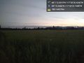
Road south of geohash @48.0184,-117.5072
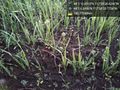
Cultivated @48.0184,-117.5072
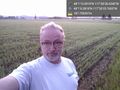
ggeohasher @48.0184,-117.5072


Achievements
Thomcat earned the Multihash Achievement
|