Difference between revisions of "2020-07-10 47 -122"
([live picture]west end of trail) |
|||
| Line 19: | Line 19: | ||
== Expedition == | == Expedition == | ||
Hmmm... that thing where you visit, take lots of pictures, and geohashdroid uploads none of them? Yeah, that happened. | Hmmm... that thing where you visit, take lots of pictures, and geohashdroid uploads none of them? Yeah, that happened. | ||
| + | |||
| + | My phone was a little low on battery; after I restarted and plugged it in I was able to upload. Not scientific, I know - but a little frustrating at the time to not notice I hadn't been uploading. | ||
| + | |||
| + | Anyhow, this location is a few miles north of my house, and we used to walk the dog through the Llandover Woods area. Just north of that is an access road to the exclusive gated community "The Highlands" - Seattle mansions that don't even show up on google street view. The geohash was somewhere in the spit of land between the parking lot and that road. | ||
| + | |||
| + | I parked at the corner of the lot (well, gravel area really) and was within 20m. Walking around, I found the spot and photographed. Also made an "X" in the dirt for other travelers, if any. Since I can't count on the photo overlay (<2m), I will either go back today or go back and reference the geo coordinates in the EXIF photo data. Success regardless. | ||
| + | |||
| + | I've hiked top to bottom in Llandover woods, and I know there is a road down there, but until today I hadn't driven down there. That was fun, some one lane road bits and a few signs that I photographed also. | ||
| + | |||
| + | I returned home at 7:30, the geohash plus commute took only half an hour. | ||
== Tracklog == | == Tracklog == | ||
| Line 30: | Line 40: | ||
Image:2020-07-10_47_-122_thomcat_1594399204370.jpg|Parked | Image:2020-07-10_47_-122_thomcat_1594399204370.jpg|Parked | ||
| − | |||
| − | |||
Image:2020-07-10_47_-122_thomcat_1594401615097.jpg|Sign | Image:2020-07-10_47_-122_thomcat_1594401615097.jpg|Sign | ||
| Line 51: | Line 59: | ||
{{#vardefine:ribbonwidth|800px}} | {{#vardefine:ribbonwidth|800px}} | ||
<!-- Add any achievement ribbons you earned below, or remove this section --> | <!-- Add any achievement ribbons you earned below, or remove this section --> | ||
| − | |||
| − | |||
| − | |||
| − | |||
| − | |||
| − | |||
| − | |||
| − | |||
| − | |||
| − | |||
| − | |||
| − | |||
| − | |||
[[Category:Expeditions]] | [[Category:Expeditions]] | ||
[[Category:Expeditions with photos]] | [[Category:Expeditions with photos]] | ||
[[Category:Coordinates reached]] | [[Category:Coordinates reached]] | ||
| − | |||
| − | |||
| − | |||
| − | |||
| − | |||
| − | |||
| − | |||
| − | |||
| − | |||
| − | |||
| − | |||
{{location|US|WA|KI}} | {{location|US|WA|KI}} | ||
Revision as of 14:06, 11 July 2020
| Fri 10 Jul 2020 in Seattle: 47.7342348, -122.3613030 geohashing.info google osm bing/os kml crox |
Location
Quite close to NW 145th and 3rd NW; parking for Llandover woods trail?
Participants
Plans
Morning visit - like right now
Expedition
Hmmm... that thing where you visit, take lots of pictures, and geohashdroid uploads none of them? Yeah, that happened.
My phone was a little low on battery; after I restarted and plugged it in I was able to upload. Not scientific, I know - but a little frustrating at the time to not notice I hadn't been uploading.
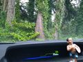
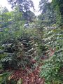
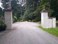
Anyhow, this location is a few miles north of my house, and we used to walk the dog through the Llandover Woods area. Just north of that is an access road to the exclusive gated community "The Highlands" - Seattle mansions that don't even show up on google street view. The geohash was somewhere in the spit of land between the parking lot and that road.
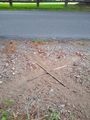
I parked at the corner of the lot (well, gravel area really) and was within 20m. Walking around, I found the spot and photographed. Also made an "X" in the dirt for other travelers, if any. Since I can't count on the photo overlay (<2m), I will either go back today or go back and reference the geo coordinates in the EXIF photo data. Success regardless.
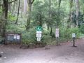
I've hiked top to bottom in Llandover woods, and I know there is a road down there, but until today I hadn't driven down there. That was fun, some one lane road bits and a few signs that I photographed also.
I returned home at 7:30, the geohash plus commute took only half an hour.
Tracklog
Photos
Parked
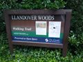
Sign
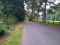
To the Highlands

geohasher
hashpoint
X marks
parking area
west end of trail


