Difference between revisions of "2020-07-19 49 -122"
From Geohashing
m (Location) |
m (More specific location) |
||
| Line 28: | Line 28: | ||
[[Category:Expeditions with photos]] | [[Category:Expeditions with photos]] | ||
[[Category:Coordinates reached]] | [[Category:Coordinates reached]] | ||
| − | {{location|CA|BC}} | + | {{location|CA|BC|MV}} |
Latest revision as of 00:20, 10 August 2020
| Sun 19 Jul 2020 in 49,-122: 49.3477734, -122.9455358 geohashing.info google osm bing/os kml crox |
Location
Mount Seymour, near a trail
Participants
Expedition
Drove up Mount Seymour Road. Parking for the closest trailhead was closed, so I drove to the next one.
Did the hike, left the trail and headed down the mountain. GPS didn't work well there, so spent a lot of time dancing.
Photos
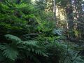
Maybe here
