Difference between revisions of "2020-07-27 50 4"
From Geohashing
(→Plans) |
m (Location) |
||
| (5 intermediate revisions by 2 users not shown) | |||
| Line 16: | Line 16: | ||
<!-- where you've surveyed the hash to be --> | <!-- where you've surveyed the hash to be --> | ||
| − | Oud Heverlee | + | Oud-Heverlee forest |
== Participants == | == Participants == | ||
| Line 49: | Line 49: | ||
<!-- Add any achievement ribbons you earned below, or remove this section --> | <!-- Add any achievement ribbons you earned below, or remove this section --> | ||
| − | + | {{land geohash | latitude = 50 | longitude = 4 | date = 2020-07-27 | name = sh}} | |
| − | + | <!-- Not the earliest geohasher achievement, sorry. This achievement only applies if several independent geohashers arrive --> | |
| − | |||
| − | |||
| − | |||
| − | |||
| − | |||
| − | |||
| − | |||
| − | |||
| − | |||
| − | |||
| − | |||
[[Category:Expeditions]] | [[Category:Expeditions]] | ||
| − | |||
[[Category:Expeditions with photos]] | [[Category:Expeditions with photos]] | ||
| − | |||
| − | |||
| − | |||
| − | |||
| − | |||
[[Category:Coordinates reached]] | [[Category:Coordinates reached]] | ||
| − | + | {{location|BE|VBR}} | |
| − | |||
| − | |||
| − | |||
| − | |||
| − | |||
| − | |||
| − | |||
| − | |||
| − | |||
| − | |||
| − | |||
| − | |||
| − | |||
| − | |||
| − | |||
| − | |||
| − | |||
Latest revision as of 17:42, 1 August 2020
| Mon 27 Jul 2020 in 50,4: 50.8341175, 4.6717752 geohashing.info google osm bing/os kml crox |
Location
Oud-Heverlee forest
Participants
Sh (talk) 11:26, 27 July 2020 (UTC)
Plans
None.
Expedition
The usual boring monday early morning breakfast. Passively swiped through the apps on my phone. Clicked the recently installed geohashing app. Found today's geohash was almost exactly on my way to work. Zommed, it was in a public forest. It rained. I did not care. This week's gonna be a good week!
Tracklog
Photos
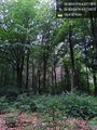
First Post ! (sic) @50.8343,4.6718

Achievements
sh earned the Land geohash achievement
|