Difference between revisions of "2020-07-29 48 7"
(→Achievements: Update bicycle distance) |
|||
| (6 intermediate revisions by the same user not shown) | |||
| Line 4: | Line 4: | ||
| date=2020-07-29 | | date=2020-07-29 | ||
}} | }} | ||
| − | |||
== Location == | == Location == | ||
| − | In a corn field, between Benfeld and Kertzfeld. | + | In a corn field, between [[wikipedia:Benfeld|Benfeld]] and Kertzfeld. |
== Participants == | == Participants == | ||
| − | [[User:Baarde|Baarde]] | + | * [[User:Baarde|Baarde]] |
== Plans == | == Plans == | ||
| Line 18: | Line 17: | ||
As I had ridden mainly on gravel paths on the way out, my hands were starting to ache a little and I decided to take a more comfortable route on my way back. I stopped in Epfig to buy some fruits, followed the EuroVelo 5 between Dambach-la-Ville and Bergheim, went home and made some lemonade. | As I had ridden mainly on gravel paths on the way out, my hands were starting to ache a little and I decided to take a more comfortable route on my way back. I stopped in Epfig to buy some fruits, followed the EuroVelo 5 between Dambach-la-Ville and Bergheim, went home and made some lemonade. | ||
| − | |||
| − | |||
== Photos == | == Photos == | ||
| − | <gallery | + | <gallery> |
Image:2020-07-29_48_7_01.jpg | Following the railway | Image:2020-07-29_48_7_01.jpg | Following the railway | ||
Image:2020-07-29_48_7_03.jpg | Trains! | Image:2020-07-29_48_7_03.jpg | Trains! | ||
| Line 32: | Line 29: | ||
== Achievements == | == Achievements == | ||
| − | {{#vardefine:ribbonwidth| | + | {{#vardefine:ribbonwidth|100%}} |
{{land geohash | {{land geohash | ||
| latitude = 48 | | latitude = 48 | ||
| Line 44: | Line 41: | ||
| date = 2020-07-29 | | date = 2020-07-29 | ||
| name = [[User:Baarde|Baarde]] | | name = [[User:Baarde|Baarde]] | ||
| − | | distance = | + | | distance = 76 km |
| bothways = true | | bothways = true | ||
}} | }} | ||
| Line 54: | Line 51: | ||
| count = 1 | | count = 1 | ||
| reached = true | | reached = true | ||
| + | }} | ||
| + | {{Last man standing | ||
| + | | latitude = 48 | ||
| + | | longitude = 7 | ||
| + | | date = 2020-07-29 | ||
| + | | name = [[User:Baarde|Baarde]] | ||
}} | }} | ||
| + | __NOTOC__ | ||
[[Category:Expeditions]] | [[Category:Expeditions]] | ||
[[Category:Expeditions with photos]] | [[Category:Expeditions with photos]] | ||
[[Category:Coordinates reached]] | [[Category:Coordinates reached]] | ||
{{location|FR|67}} | {{location|FR|67}} | ||
Latest revision as of 11:16, 16 August 2021
| Wed 29 Jul 2020 in 48,7: 48.3815107, 7.5815551 geohashing.info google osm bing/os kml crox |
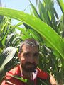
Location
In a corn field, between Benfeld and Kertzfeld.
Participants
Plans
The plan was to take my bike, ride from Sélestat to Benfeld along the railway and hope I wouldn't end up in a corn field.
Expedition
I left home before noon and rode to Sélestat. From there I followed the railway up to Benfeld. As I expected, the location was in a corn field but that wasn't enough to stop me. I left my bike and hiked about 20 meters between the stalks (careful not to damage anything) before reaching the coordinate.
As I had ridden mainly on gravel paths on the way out, my hands were starting to ache a little and I decided to take a more comfortable route on my way back. I stopped in Epfig to buy some fruits, followed the EuroVelo 5 between Dambach-la-Ville and Bergheim, went home and made some lemonade.
Photos
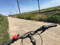
Following the railway
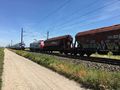
Trains!
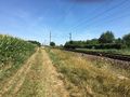
Should have taken the train…
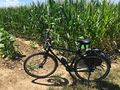
It's a corn field
Stup grin
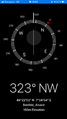
Coordinates reached


Achievements
Baarde earned the Land geohash achievement
|
Baarde earned the Bicycle geohash achievement
|

Baarde earned the Last man standing achievement
|