Difference between revisions of "2020-08-15 49 8"
([live picture]Proof) |
m (Location correction) |
||
| (One intermediate revision by one other user not shown) | |||
| Line 1: | Line 1: | ||
| − | + | {{meetup graticule | |
| − | |||
| − | |||
| − | |||
| − | |||
| − | |||
| − | |||
| − | |||
| − | |||
| lat=49 | | lat=49 | ||
| lon=8 | | lon=8 | ||
| date=2020-08-15 | | date=2020-08-15 | ||
| − | }} | + | }} |
| + | |||
__NOTOC__ | __NOTOC__ | ||
| + | |||
== Location == | == Location == | ||
<!-- where you've surveyed the hash to be --> | <!-- where you've surveyed the hash to be --> | ||
| + | In a mowed down meadow or field. | ||
== Participants == | == Participants == | ||
<!-- who attended: If you link to your wiki user name in this section, your expedition will be picked up by the various statistics generated for geohashing. You may use three tildes ~ as a shortcut to automatically insert the user signature of the account you are editing with. | <!-- who attended: If you link to your wiki user name in this section, your expedition will be picked up by the various statistics generated for geohashing. You may use three tildes ~ as a shortcut to automatically insert the user signature of the account you are editing with. | ||
--> | --> | ||
| + | * [[User:Lyrla|Lyrla]] | ||
== Plans == | == Plans == | ||
<!-- what were the original plans --> | <!-- what were the original plans --> | ||
| + | Go there ~24km by bike and have a good time. | ||
| + | |||
| + | This hash was really close (~200m) to a route I have taken hundreds of times in the last 20 years so it was well known terrain. Nonetheless I had no plans what to do and what to experience on that trip. | ||
| + | |||
| + | |||
== Expedition == | == Expedition == | ||
<!-- how it all turned out. your narrative goes here. --> | <!-- how it all turned out. your narrative goes here. --> | ||
| + | It started really bad with an unwanted interaction with german authorities that wanted me to not ride my bike (even though it was walking pace) in a no-bike-zone and instead use the street where cars pass bikes really close with 50 km/h and faster and don't pay attention to bikers. But it is what it is and this is not the right platform to discuss german authorities and traffic regulations and how reasonable they are. | ||
| − | + | A few kilometers closer to the hash I stopped at a nice small beach and I'm a simple man: I see water, I put my feet in. | |
| − | + | A little later I went for the hash. It was pretty easy to find and I had a nice sunset there. | |
| + | After a rather chilled ride to the hash I chose an athletic approach for the way back and had some fun putting everything I had into my legs. | ||
== Photos == | == Photos == | ||
| Line 51: | Line 54: | ||
{{#vardefine:ribbonwidth|800px}} | {{#vardefine:ribbonwidth|800px}} | ||
<!-- Add any achievement ribbons you earned below, or remove this section --> | <!-- Add any achievement ribbons you earned below, or remove this section --> | ||
| + | {{#vardefine:ribbonwidth|800px}} | ||
| + | {{Land geohash | ||
| + | | latitude = 49 | ||
| + | | longitude = 8 | ||
| + | | date = 2020-08-15 | ||
| + | | name = [[User:Lyrla|Lyrla]] | ||
| + | }} | ||
| + | {{bicycle geohash | ||
| + | | latitude = 49 | ||
| + | | longitude = 8 | ||
| + | | date = 2020-08-15 | ||
| + | | name = [[User:Lyrla|Lyrla]] | ||
| + | | distance = 24km | ||
| + | | bothways = true | ||
| + | }} | ||
| − | |||
| − | |||
| − | |||
| − | |||
| − | |||
| − | |||
| − | |||
| − | |||
| − | |||
| − | |||
| − | |||
| − | |||
| − | |||
| − | |||
[[Category:Expeditions]] | [[Category:Expeditions]] | ||
| − | |||
[[Category:Expeditions with photos]] | [[Category:Expeditions with photos]] | ||
| − | |||
| − | |||
| − | |||
| − | |||
| − | |||
[[Category:Coordinates reached]] | [[Category:Coordinates reached]] | ||
| − | + | {{location|DE|HE|GG}} | |
| − | |||
| − | |||
| − | |||
| − | |||
| − | |||
| − | |||
| − | |||
| − | |||
| − | |||
| − | |||
| − | |||
| − | |||
| − | |||
| − | |||
| − | |||
| − | |||
| − | |||
Latest revision as of 07:13, 1 September 2020
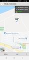
| Sat 15 Aug 2020 in 49,8: 49.9980472, 8.3585748 geohashing.info google osm bing/os kml crox |
Location
In a mowed down meadow or field.
Participants
Plans
Go there ~24km by bike and have a good time.
This hash was really close (~200m) to a route I have taken hundreds of times in the last 20 years so it was well known terrain. Nonetheless I had no plans what to do and what to experience on that trip.
Expedition
It started really bad with an unwanted interaction with german authorities that wanted me to not ride my bike (even though it was walking pace) in a no-bike-zone and instead use the street where cars pass bikes really close with 50 km/h and faster and don't pay attention to bikers. But it is what it is and this is not the right platform to discuss german authorities and traffic regulations and how reasonable they are.
A few kilometers closer to the hash I stopped at a nice small beach and I'm a simple man: I see water, I put my feet in. A little later I went for the hash. It was pretty easy to find and I had a nice sunset there. After a rather chilled ride to the hash I chose an athletic approach for the way back and had some fun putting everything I had into my legs.
Photos

Panorama at the hash @49.9980,8.3586
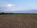
At the hash
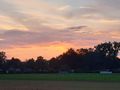
Sunset at the hash
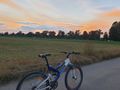
Bike close to the hash
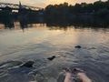
Had to take a break here because feet and water work like magnets
Proof


Achievements
Lyrla earned the Land geohash achievement
|
Lyrla earned the Bicycle geohash achievement
|