Difference between revisions of "2020-08-17 48 7"
(→Achievements: Update bicycle distance) |
|||
| (6 intermediate revisions by the same user not shown) | |||
| Line 5: | Line 5: | ||
}} | }} | ||
== Location == | == Location == | ||
| − | In a vineyard above Sigolsheim. | + | In a vineyard above [[wikipedia:Sigolsheim|Sigolsheim]]. |
== Participants == | == Participants == | ||
| − | [[User:Baarde|Baarde]] | + | * [[User:Baarde|Baarde]] |
== Expedition == | == Expedition == | ||
| + | I cycled to Ribeauvillé and took a small road, parallel to the Eurovelo 5, which goes over the hills, trough the vineyards and down to Kientzheim. | ||
| + | |||
| + | The coordinates were in a vineyard above the nearby town of Sigolsheim. From there, I had a nice view on the town and the Kaysersberg valley. | ||
| + | |||
| + | After reaching the geohash, I climbed to the military cemetery located on the top of the hill, just a few hundreds meters from there. It hosts the graves of French soldiers who died in the Battle of the Colmar Pocket during Winter 1944-45. | ||
| + | |||
| + | Then I went to Kaysersberg to have drink with a piece of blueberry pie and buy a postcard. | ||
== Photos == | == Photos == | ||
| − | <gallery | + | <gallery> |
Image:2020-08-17 48 7 01.jpg | On the road from Riquewihr | Image:2020-08-17 48 7 01.jpg | On the road from Riquewihr | ||
Image:2020-08-17 48 7 02.jpg | Passing in Kientzheim | Image:2020-08-17 48 7 02.jpg | Passing in Kientzheim | ||
| Line 21: | Line 28: | ||
Image:2020-08-17 48 7 06.jpg | Stupid grin | Image:2020-08-17 48 7 06.jpg | Stupid grin | ||
Image:2020-08-17 48 7 07.jpg | Sigolsheim | Image:2020-08-17 48 7 07.jpg | Sigolsheim | ||
| + | Image:2020-08-17 48 7 10.jpg | Sigolsheim National Cemetery | ||
| + | Image:2020-08-17 48 7 09.jpg | Memorial to fallen U.S. troops | ||
| + | Image:2020-08-17 48 7 11.jpg | Cycling to Kaysersberg | ||
Image:2020-08-17 48 7 08.jpg | That would look nice on a postcard | Image:2020-08-17 48 7 08.jpg | That would look nice on a postcard | ||
</gallery> | </gallery> | ||
== Achievements == | == Achievements == | ||
| − | {{#vardefine:ribbonwidth| | + | {{#vardefine:ribbonwidth|100%}} |
{{land geohash | {{land geohash | ||
| latitude = 48 | | latitude = 48 | ||
| Line 37: | Line 47: | ||
| date = 2020-08-17 | | date = 2020-08-17 | ||
| name = [[User:Baarde|Baarde]] | | name = [[User:Baarde|Baarde]] | ||
| − | | distance = | + | | distance = 51 km |
| bothways = true | | bothways = true | ||
}} | }} | ||
Latest revision as of 11:19, 16 August 2021
| Mon 17 Aug 2020 in 48,7: 48.1359797, 7.3102063 geohashing.info google osm bing/os kml crox |
Location
In a vineyard above Sigolsheim.
Participants
Expedition
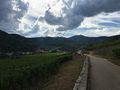
I cycled to Ribeauvillé and took a small road, parallel to the Eurovelo 5, which goes over the hills, trough the vineyards and down to Kientzheim.
The coordinates were in a vineyard above the nearby town of Sigolsheim. From there, I had a nice view on the town and the Kaysersberg valley.
After reaching the geohash, I climbed to the military cemetery located on the top of the hill, just a few hundreds meters from there. It hosts the graves of French soldiers who died in the Battle of the Colmar Pocket during Winter 1944-45.
Then I went to Kaysersberg to have drink with a piece of blueberry pie and buy a postcard.
Photos
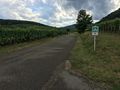
On the road from Riquewihr
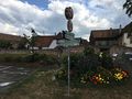
Passing in Kientzheim
A few meters above the geohash
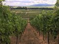
Strolling in the vineyard
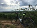
Coordinates reached
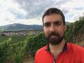
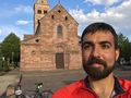
Stupid grin
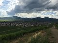
Sigolsheim
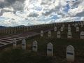
Sigolsheim National Cemetery
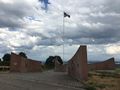
Memorial to fallen U.S. troops
Cycling to Kaysersberg
That would look nice on a postcard


Achievements
Baarde earned the Land geohash achievement
|
Baarde earned the Bicycle geohash achievement
|
