Difference between revisions of "2020-08-18 52 9"
(→Expedition) |
m (Category) |
||
| (13 intermediate revisions by 3 users not shown) | |||
| Line 1: | Line 1: | ||
| − | + | <!-- English für AperfectBot | |
| − | + | ==Location== | |
| − | [[ | + | This Geohash is located in a forest in Hildesheim |
| − | + | ==Participants== | |
| − | + | *[[User:JoDaEmPa|JoDaEmPa]] | |
| − | + | --> | |
| − | + | {{meetup graticule | |
| − | + | | lat=52 | |
| − | -->{{meetup graticule | + | | lon=9 |
| − | | lat= | + | | date=2020-08-18 |
| − | | lon= | + | }} |
| − | | date= | ||
| − | }} | ||
| − | |||
== Ort == | == Ort == | ||
Hildsheim | Hildsheim | ||
| − | == | + | == Probleme == |
Hier siehst du eine unfertige Seite ! | Hier siehst du eine unfertige Seite ! | ||
Einen GEOHASH zu Loggen ist Käse ! | Einen GEOHASH zu Loggen ist Käse ! | ||
| + | |||
| + | ==Teilnehmer== | ||
| + | *[[User:JoDaEmPa|JoDaEmPa]] | ||
| + | |||
| + | == Die Plannung == | ||
| + | Mein Plan ist endstanden durch den heutigen Kurs des dow-jones ! | ||
| + | Eröffnung/Vortag 27.778,07PKT | ||
| + | Ein Opencache sollte meinen Fund markieren ! | ||
| + | |||
| + | https://www.godmode-trader.de/indizes/dow-jones-industrial-average-index-price-usd-kurs,133965 | ||
| + | |||
Um den OpenCache zu finden must du auf da Datum 2020-08-18 und die Koordinate von N52° E9° klicken ! | Um den OpenCache zu finden must du auf da Datum 2020-08-18 und die Koordinate von N52° E9° klicken ! | ||
| − | |||
| − | |||
| − | |||
| − | |||
| − | + | https://opencaching.de/OC16471 | |
| − | |||
== Das Abenteuer == | == Das Abenteuer == | ||
| Line 34: | Line 37: | ||
Mit einer Telescope Stange bewaffnet pflügte ich mich durch den leichten Dschungel! | Mit einer Telescope Stange bewaffnet pflügte ich mich durch den leichten Dschungel! | ||
3 Meter vor dem Zaun vom Privat gelände sagte mein Handy dann "0 Meter" | 3 Meter vor dem Zaun vom Privat gelände sagte mein Handy dann "0 Meter" | ||
| − | Ich hatte | + | Ich hatte eigentlich schon gehofft, daß ich für ein Foto doch die Teleskopestange bräüchte. |
| + | Ich hätte dann das Handy, auf das Privat-Gelände schweben lassen ! | ||
Aber so war es auch lustig ! | Aber so war es auch lustig ! | ||
Den Opencache habe ich dann 11 meter richtung Süden versteckt ! | Den Opencache habe ich dann 11 meter richtung Süden versteckt ! | ||
Hat Spass gemacht ! | Hat Spass gemacht ! | ||
| − | |||
| − | |||
| − | |||
| − | |||
| − | |||
== Photos == | == Photos == | ||
| − | |||
| − | |||
| − | |||
<gallery perrow="5"> | <gallery perrow="5"> | ||
Screenshot 2020-08-18-15-56-08.png| Screenshot von Oben | Screenshot 2020-08-18-15-56-08.png| Screenshot von Oben | ||
| Line 57: | Line 53: | ||
Daumen-18-08-20.jpg| Geschaft ! Den Hash zu finden ist einfach, die Seite zu basteln ist ... | Daumen-18-08-20.jpg| Geschaft ! Den Hash zu finden ist einfach, die Seite zu basteln ist ... | ||
20200818 161301.jpg| 11Meter richtung Süden beim Opencache | 20200818 161301.jpg| 11Meter richtung Süden beim Opencache | ||
| + | </gallery> | ||
| − | + | == Achievements Erfolge == | |
| + | Vielleicht gibt es ja einen erfolg, dafür einen Opencache zu legen an der stelle wo der Hash war ! | ||
| + | Aber wie ich das jetzt finde, weiss ich nicht bei GeoHasching nicht ? | ||
| − | |||
{{#vardefine:ribbonwidth|800px}} | {{#vardefine:ribbonwidth|800px}} | ||
<!-- Add any achievement ribbons you earned below, or remove this section --> | <!-- Add any achievement ribbons you earned below, or remove this section --> | ||
| − | + | __NOTOC__ | |
| − | |||
| − | |||
| − | |||
| − | |||
| − | |||
| − | |||
| − | |||
| − | |||
| − | |||
| − | |||
| − | |||
| − | |||
| − | |||
[[Category:Expeditions]] | [[Category:Expeditions]] | ||
| − | |||
[[Category:Expeditions with photos]] | [[Category:Expeditions with photos]] | ||
| − | |||
| − | |||
| − | |||
| − | |||
| − | |||
[[Category:Coordinates reached]] | [[Category:Coordinates reached]] | ||
| − | + | [[Category:Pages in German]] | |
| − | + | {{location|DE|NI|HI}} | |
| − | |||
| − | |||
| − | |||
| − | |||
| − | |||
| − | |||
| − | |||
| − | |||
| − | |||
| − | |||
| − | [[Category: | ||
| − | |||
| − | |||
| − | |||
| − | |||
| − | |||
Latest revision as of 12:20, 10 January 2022
| Tue 18 Aug 2020 in 52,9: 52.1429817, 9.9310467 geohashing.info google osm bing/os kml crox |
Ort
Hildsheim
Probleme
Hier siehst du eine unfertige Seite ! Einen GEOHASH zu Loggen ist Käse !
Teilnehmer
Die Plannung
Mein Plan ist endstanden durch den heutigen Kurs des dow-jones ! Eröffnung/Vortag 27.778,07PKT Ein Opencache sollte meinen Fund markieren !
https://www.godmode-trader.de/indizes/dow-jones-industrial-average-index-price-usd-kurs,133965
Um den OpenCache zu finden must du auf da Datum 2020-08-18 und die Koordinate von N52° E9° klicken !
https://opencaching.de/OC16471
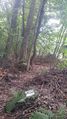
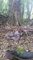
Das Abenteuer
Ich bin mit Fahrrad zu Fuß von der Berghölzchen seite hoch, in der Kurve runter in den Wald !
;-))))))
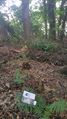
Ich wuste nicht ob sich der Hash auf Privat gelände befindet ! Mit einer Telescope Stange bewaffnet pflügte ich mich durch den leichten Dschungel! 3 Meter vor dem Zaun vom Privat gelände sagte mein Handy dann "0 Meter" Ich hatte eigentlich schon gehofft, daß ich für ein Foto doch die Teleskopestange bräüchte. Ich hätte dann das Handy, auf das Privat-Gelände schweben lassen ! Aber so war es auch lustig ! Den Opencache habe ich dann 11 meter richtung Süden versteckt ! Hat Spass gemacht !
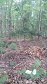
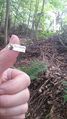
Photos
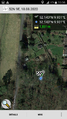
Screenshot von Oben
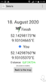
Screenshot mit Koo's
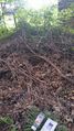
Richtung Nord, Privater eingang vom Wald!
Richtung Osten
Richtung West
Richtung Süd
Geschaft ! Den Hash zu finden ist einfach, die Seite zu basteln ist ...
11Meter richtung Süden beim Opencache


Achievements Erfolge
Vielleicht gibt es ja einen erfolg, dafür einen Opencache zu legen an der stelle wo der Hash war ! Aber wie ich das jetzt finde, weiss ich nicht bei GeoHasching nicht ?