Difference between revisions of "2020-08-25 47 -122"
([live picture]Brewery [https://openstreetmap.org/?lat=47.54968240&lon=-122.06648860&zoom=16&layers=B000FTF @47.5497,-122.0665]) |
|||
| Line 1: | Line 1: | ||
| − | + | {{meetup graticule | |
| − | |||
| − | |||
| − | |||
| − | |||
| − | |||
| − | |||
| − | |||
| − | |||
| lat=47 | | lat=47 | ||
| lon=-122 | | lon=-122 | ||
| date=2020-08-25 | | date=2020-08-25 | ||
| − | }} | + | | graticule_name=Seattle |
| + | | graticule_link=Seattle, Washington | ||
| + | }} | ||
__NOTOC__ | __NOTOC__ | ||
== Location == | == Location == | ||
| − | + | Near a freeway onramp in Issaquah. | |
== Participants == | == Participants == | ||
| − | + | * [[User:Thomcat|Thomcat]] | |
| − | |||
== Plans == | == Plans == | ||
| − | + | Stop by after work | |
== Expedition == | == Expedition == | ||
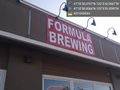
| − | + | Not terribly far out of the way, and an excuse to fill the gas tank AND visit a brewery I've not been to. | |
| + | |||
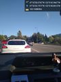
| + | Freeway getting more crowded, but still not too bad. I found the exit and was within 100m, then turned off for gas. | ||
| + | |||
| + | Returning, I parked behind the geohash, but a fence blocked access. I *may* have been better off jumping the fence, though. | ||
| + | |||
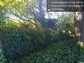
| + | Walking around the parking lot, I spotted a doughnut store and bought rations for the expedition. Then I rounded the corner to see... no sidewalk. Oh, and blackberry vines crawling over the Jersey barrier, reaching out for unsuspecting cars and bare-legged geohashers. | ||
| + | |||
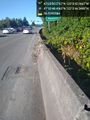
| + | I made my way up the road, avoiding cars and feeling small. Finding a spot where the bushes were less, I jumped the barrier and continued with a little more protection. Once nearest the point, the vines were thin enough that I could reach in and pick a few berries - but I opted not to dive through them to reach the actual spot. 9m was the closest I got. | ||
| + | |||
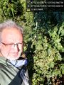
| + | Fortunately mother nature provided no such barrier to a delicious Vienna Lager, just right to salve my pride. Not *quite* in sight of the geohash point, but still worth the visit! | ||
== Tracklog == | == Tracklog == | ||
| Line 50: | Line 53: | ||
<!-- Add any achievement ribbons you earned below, or remove this section --> | <!-- Add any achievement ribbons you earned below, or remove this section --> | ||
| − | |||
| − | |||
| − | |||
| − | |||
| − | |||
| − | |||
| − | |||
| − | |||
| − | |||
| − | |||
| − | |||
| − | |||
| − | |||
| − | |||
[[Category:Expeditions]] | [[Category:Expeditions]] | ||
| − | |||
[[Category:Expeditions with photos]] | [[Category:Expeditions with photos]] | ||
| − | |||
| − | |||
| − | |||
| − | |||
| − | |||
| − | |||
| − | |||
| − | |||
| − | |||
[[Category:Coordinates not reached]] | [[Category:Coordinates not reached]] | ||
| − | |||
| − | |||
[[Category:Not reached - Mother Nature]] | [[Category:Not reached - Mother Nature]] | ||
| − | |||
| − | |||
| − | |||
| − | |||
| − | |||
| − | |||
| − | |||
| − | |||
| − | |||
| − | |||
| − | |||
Revision as of 14:12, 26 August 2020
| Tue 25 Aug 2020 in Seattle: 47.5472435, -122.0619352 geohashing.info google osm bing/os kml crox |
Location
Near a freeway onramp in Issaquah.
Participants
Plans
Stop by after work
Expedition
Not terribly far out of the way, and an excuse to fill the gas tank AND visit a brewery I've not been to.
Freeway getting more crowded, but still not too bad. I found the exit and was within 100m, then turned off for gas.
Returning, I parked behind the geohash, but a fence blocked access. I *may* have been better off jumping the fence, though.
Walking around the parking lot, I spotted a doughnut store and bought rations for the expedition. Then I rounded the corner to see... no sidewalk. Oh, and blackberry vines crawling over the Jersey barrier, reaching out for unsuspecting cars and bare-legged geohashers.
I made my way up the road, avoiding cars and feeling small. Finding a spot where the bushes were less, I jumped the barrier and continued with a little more protection. Once nearest the point, the vines were thin enough that I could reach in and pick a few berries - but I opted not to dive through them to reach the actual spot. 9m was the closest I got.
Fortunately mother nature provided no such barrier to a delicious Vienna Lager, just right to salve my pride. Not *quite* in sight of the geohash point, but still worth the visit!
Tracklog
Photos
Nearly there @47.5480,-122.0627
No access @47.5470,-122.0620
No sidewalk @47.5468,-122.0623
Blackberries @47.5472,-122.0620
Brewery @47.5497,-122.0665


