Difference between revisions of "2020-09-08 47 8"
(→Plans) |
(→Achievements) |
||
| (10 intermediate revisions by 2 users not shown) | |||
| Line 1: | Line 1: | ||
<!-- If you did not specify these parameters in the template, please substitute appropriate values for IMAGE, LAT, LON, and DATE (YYYY-MM-DD format) | <!-- If you did not specify these parameters in the template, please substitute appropriate values for IMAGE, LAT, LON, and DATE (YYYY-MM-DD format) | ||
| − | |||
| − | |||
| − | |||
| − | |||
| − | |||
And DON'T FORGET to add your expedition and the best photo you took to the gallery on the Main Page! We'd love to read your report, but that means we first have to discover it! :) | And DON'T FORGET to add your expedition and the best photo you took to the gallery on the Main Page! We'd love to read your report, but that means we first have to discover it! :) | ||
| Line 27: | Line 22: | ||
== Expedition == | == Expedition == | ||
<!-- how it all turned out. your narrative goes here. --> | <!-- how it all turned out. your narrative goes here. --> | ||
| + | Finally my first GeoHash! I was watching the points for years but it was always to far for my lazy car-less ass. But today a spot was close by. Just a bit over a hour of train and bus ride plus half a hour walking (one way of course). Then it was in a beautiful valley on a fresh cut grass field. To easy so I added some GeoCaches in tunnels and on slippery hillsides. | ||
| + | |||
| + | While waiting for a good lock on the spot, some bikers passed by. They think I was searching for mice's or some thing as I didn't dear to explain... | ||
| + | |||
| + | It was a nice evening trip. | ||
| + | |||
| + | I logged it also as [https://opencaching.earth/OCF495 Safari-Cache]. | ||
== Tracklog == | == Tracklog == | ||
| − | + | I sadly only started the track when I reached Baar. | |
| + | [[:File:2020-09-08 47 8.gpx]] | ||
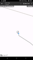
| + | [[File:2020-09-08 47 8 Trackshot.png|400px]] | ||
== Photos == | == Photos == | ||
| Line 36: | Line 40: | ||
--> | --> | ||
<gallery perrow="5"> | <gallery perrow="5"> | ||
| − | + | Image:2020-09-08_47_8_Tungmar_1599594345714.jpg| Close enough | |
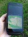
| − | Image:2020-09-08_47_8_Tungmar_1599594345714.jpg| | + | Image:2020-09-08 47 8 cgeo.png| Closest noted measure |
| − | + | Image:2020-09-08 47 8 phone photo phone.jpeg| Old phone taking a photo of the new phone at the hash | |
| − | + | Image:2020-09-08 47 8 view north.jpeg| View to north | |
| − | + | Image:2020-09-08 47 8 view 300something.jpeg| 300something degree view | |
| − | |||
</gallery> | </gallery> | ||
== Achievements == | == Achievements == | ||
{{#vardefine:ribbonwidth|800px}} | {{#vardefine:ribbonwidth|800px}} | ||
| − | + | {{Land geohash | latitude=47 | longitude=8 | date=2020-09-08 | name=[[User:Tungmar|Tungmar]]}} | |
| − | + | {{Public transport geohash | latitude=47 | longitude=8 | date=2020-09-08 | name=[[User:Tungmar|Tungmar]]}} | |
| − | + | {{Two to the N achievement | count=0 | date=2020-09-08 | latitude=47 | longitude=8 | name=[[User:Tungmar|Tungmar]] | reached=true}} | |
| − | |||
| − | [[ | ||
| − | |||
| − | |||
| − | |||
| − | |||
| − | |||
| − | |||
| − | |||
| − | |||
| − | |||
| − | |||
[[Category:Expeditions]] | [[Category:Expeditions]] | ||
| − | |||
[[Category:Expeditions with photos]] | [[Category:Expeditions with photos]] | ||
| − | |||
| − | |||
| − | |||
| − | |||
| − | |||
[[Category:Coordinates reached]] | [[Category:Coordinates reached]] | ||
| − | + | {{location|CH|ZH}} | |
| − | |||
| − | |||
| − | |||
| − | |||
| − | |||
| − | |||
| − | |||
| − | |||
| − | |||
| − | |||
| − | |||
| − | |||
| − | |||
| − | |||
| − | |||
| − | |||
| − | |||
Latest revision as of 09:04, 28 November 2020
| Tue 8 Sep 2020 in 47,8: 47.2231625, 8.5673579 geohashing.info google osm bing/os kml crox |
Location
A grass field near Sihlbrugg.
Participants
Plans
Go to Sihlbrugg by public transport and walk up the hill.
Expedition
Finally my first GeoHash! I was watching the points for years but it was always to far for my lazy car-less ass. But today a spot was close by. Just a bit over a hour of train and bus ride plus half a hour walking (one way of course). Then it was in a beautiful valley on a fresh cut grass field. To easy so I added some GeoCaches in tunnels and on slippery hillsides.
While waiting for a good lock on the spot, some bikers passed by. They think I was searching for mice's or some thing as I didn't dear to explain...
It was a nice evening trip.
I logged it also as Safari-Cache.
Tracklog
I sadly only started the track when I reached Baar.
File:2020-09-08 47 8.gpx

Photos

Close enough
Closest noted measure
Old phone taking a photo of the new phone at the hash
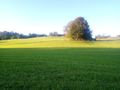
View to north
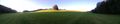
300something degree view


Achievements
Tungmar earned the Land geohash achievement
|
Tungmar earned the Public transport geohash achievement
|
