Difference between revisions of "2020-09-08 47 8"
(→Achievements) |
|||
| (9 intermediate revisions by 2 users not shown) | |||
| Line 27: | Line 27: | ||
It was a nice evening trip. | It was a nice evening trip. | ||
| + | |||
| + | I logged it also as [https://opencaching.earth/OCF495 Safari-Cache]. | ||
== Tracklog == | == Tracklog == | ||
| − | + | I sadly only started the track when I reached Baar. | |
| + | [[:File:2020-09-08 47 8.gpx]] | ||
| + | [[File:2020-09-08 47 8 Trackshot.png|400px]] | ||
== Photos == | == Photos == | ||
| Line 36: | Line 40: | ||
--> | --> | ||
<gallery perrow="5"> | <gallery perrow="5"> | ||
| − | + | Image:2020-09-08_47_8_Tungmar_1599594345714.jpg| Close enough | |
| − | Image:2020-09-08_47_8_Tungmar_1599594345714.jpg| | + | Image:2020-09-08 47 8 cgeo.png| Closest noted measure |
| + | Image:2020-09-08 47 8 phone photo phone.jpeg| Old phone taking a photo of the new phone at the hash | ||
| + | Image:2020-09-08 47 8 view north.jpeg| View to north | ||
| + | Image:2020-09-08 47 8 view 300something.jpeg| 300something degree view | ||
</gallery> | </gallery> | ||
== Achievements == | == Achievements == | ||
{{#vardefine:ribbonwidth|800px}} | {{#vardefine:ribbonwidth|800px}} | ||
| − | + | {{Land geohash | latitude=47 | longitude=8 | date=2020-09-08 | name=[[User:Tungmar|Tungmar]]}} | |
| − | + | {{Public transport geohash | latitude=47 | longitude=8 | date=2020-09-08 | name=[[User:Tungmar|Tungmar]]}} | |
| − | + | {{Two to the N achievement | count=0 | date=2020-09-08 | latitude=47 | longitude=8 | name=[[User:Tungmar|Tungmar]] | reached=true}} | |
| − | |||
| − | [[ | ||
| − | |||
| − | |||
| − | |||
| − | |||
| − | |||
| − | [[ | ||
| − | -- | ||
| − | |||
| − | |||
| − | |||
[[Category:Expeditions]] | [[Category:Expeditions]] | ||
| − | |||
[[Category:Expeditions with photos]] | [[Category:Expeditions with photos]] | ||
| − | |||
| − | |||
| − | |||
| − | |||
| − | |||
[[Category:Coordinates reached]] | [[Category:Coordinates reached]] | ||
| − | + | {{location|CH|ZH}} | |
| − | |||
| − | |||
| − | |||
| − | |||
| − | |||
| − | |||
| − | |||
| − | |||
| − | |||
| − | |||
| − | |||
| − | |||
| − | |||
| − | |||
| − | |||
| − | |||
| − | |||
Latest revision as of 09:04, 28 November 2020
| Tue 8 Sep 2020 in 47,8: 47.2231625, 8.5673579 geohashing.info google osm bing/os kml crox |
Location
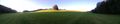
A grass field near Sihlbrugg.
Participants
Plans
Go to Sihlbrugg by public transport and walk up the hill.
Expedition
Finally my first GeoHash! I was watching the points for years but it was always to far for my lazy car-less ass. But today a spot was close by. Just a bit over a hour of train and bus ride plus half a hour walking (one way of course). Then it was in a beautiful valley on a fresh cut grass field. To easy so I added some GeoCaches in tunnels and on slippery hillsides.
While waiting for a good lock on the spot, some bikers passed by. They think I was searching for mice's or some thing as I didn't dear to explain...
It was a nice evening trip.
I logged it also as Safari-Cache.
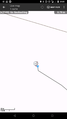
Tracklog
I sadly only started the track when I reached Baar.
File:2020-09-08 47 8.gpx

Photos
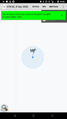
Close enough
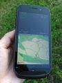
Closest noted measure
Old phone taking a photo of the new phone at the hash
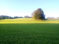
View to north
300something degree view


Achievements
Tungmar earned the Land geohash achievement
|
Tungmar earned the Public transport geohash achievement
|
